Darkness and Light

Evening on the Susquehanna

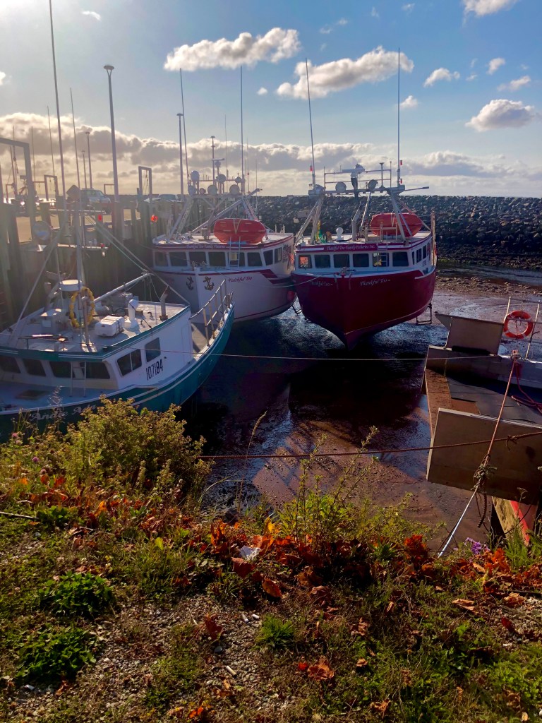
Our camp on the Susquehanna was pretty much right in the path of a decent sized storm. It probably wasn’t going to hit us until about 8 in the morning, but by 5:30, the winds were gusting to 25, and ceiling was sinking lower and lower. It was going to be a dark day of travel and it needed to start soon.

The Susquehanna River is one of the oldest rivers in the United States.  It is 444 miles long (the longest in the eastern US), has two branches, drains over 27,000 square miles of land, and empties into the Chesapeake Bay, accounting the bulk of the fresh water into that ecosystem.  And, as I learned today, it’s damn scary.

My traveling partner on this trip through hiked the Appalachian trail in the early 90s. One of his key memories from that trip was a visit to the Doyle Hotel in Duncannon, PA.  So, naturally, when we were in the area, we felt the need to revisit the old hotel, which is apparently legendary among AT hikers. The primary reason my partner ended up at the Doyle, was a gruesome double murder in a shelter just above Duncannon on the trail the year before he passed through.  Not wanting to stay in the shelter, he and his crew hustled down to the Doyle for the night.  The Doyle has seen better days and is barely hanging on today.  The place was closed to any traffic before 11 am, and only open for hikers via a convoluted, double secret entrance to the balcony during the day after 11.  So we took a picture for the memory book and wandered around the very downtrodden town of Duncannon.

An unexpected history

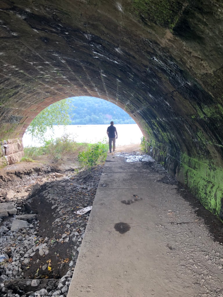
Most of the streets of Duncannon that lead down to the Susquehanna end by draining under stone arches of the railroad line that follows the river.  I thought they were picturesque and wanted to go down to the river and under one of the arches.  It’s very sketchy in a methamphetamine/oxycodone sort of poor Appalachian way, but it does look cool.  We walked under the dank, moody archway while a garbage train was parked above on the tracks, steaming and stinking.  Just under the archway, the river looked like a painting in the approaching storm, and we were so focused on it we didn’t really notice the guy leaning against the backside of the arch as we passed through.  He was having a coffee and smoking a cigarette and he was in the mood to chat.  My partner wandered along the river while I engaged the local.

This is a nice spot, I said, do you come here to get things sorted out in peace? Yeah, here and the one up the river he said.  A lot of people come here.  They don’t take care of it as you can see.  They come to make a fire and drink and hang out.  It’s not really legal, but everyone does it.  They found a guy hanging in that tree right there last week.  He was foaming at the mouth and I don’t think he hung himself.  A month ago a girl committed suicide on the other side here. I knew her, we know everyone in town, like I know you aren’t from here.  She didn’t kill herself, I don’t think.  And a few years ago they arrested a serial killer at the next arches — they call them six arch.  He was a bad guy. 

At this point, I was uneasy. Well, I said, the river looks beautiful from here.  Yeah, he said, you can walk a cross it.  It’s only 3 feet deep.  I mean there are some holes, but most people don’t know where they are.  I do. 

So, to recap, I’m at the edge of a river surrounded by apparently recent murder scenes, with some drifter who knows where the holes in the river are.  We had been following and admiring the Susquehanna since Binghampton, NY, and it was taking on an entirely new perspective for me now.  I thanked the guy for the information about the river, apologized for interrupting his coffee, gathered up my partner and got the truck as soon as I could.  It’s funny now, but there was a darkness both in Duncannon and at the edge of the river that was both pitiful and terrifying. Pitiful because Duncannon clearly was a town of some success and importance in the past, but it is a sad display of decaying Appalachia today; and terrifying because I was at one single spot on the longest river in the eastern US and all this bad stuff happened here — imagine what all has happened along its length.  It will take a minute, but I will remember this spot for the beauty of the river, just below the juncture of its two branches, carving along the granite bluffs, shallow and soft, and completely innocent of the evils along its banks. I have to, for the alternative is a sad cup of coffee and a cigarette with no, or at least very little, hope.

The gathering storm on the Susquehanna

We wound south of the river and rolled through the rolling farm fields just west of the Allegheny range of the Appalachians, down to Gettysburg.  On the fields and ridges here, in the bloodiest of all Civil War battles, over 50,000 men died, and the Confederacy effectively lost the war.  Lee believed winning a big battle in the territory of the north would precipitate a negotiated peace, and after his defeat here, it ultimately did — just not the one he expected, and one that came at much greater cost in lives. I was surprised at how many people were in the Gettysburg National Park. The parking spilled over into the overflow lots. And while the profiteering lies right along the education, (Battlefield Fries!) I think it is important to mark this place and to understand what happened here beyond the tactics and body count.

From southern Pennsylvania, things got a great deal simpler — simply keep the blue ridge mountains on my left shoulder, and head for home.  I will have plenty of time to think about this Eastern Reach.  To put the full extent of Appalachia, from one end to the other, into the collection of places I’ve visited.  There are stories in them all, history in them all, beauty in them all. And there is “us” in them all, in one way or another.  Our sins and successes, washed in the rivers, dug into the mines, and paved through the mountain passes. These places changed us and we continue to change them, sometimes with the hand of a great artist or teacher, and sometimes with the very worst of ourselves. But there is a resilience to the oldest mountains on the continent, a wisdom amidst the smoke and surf and freestone falls, that can only come with age. 

I believe they share it with everyone who visits. If you can just reach far enough. 

A Proper Mixture

North Pond, Brandt Lake NY

You could say that the Adirondacks section of the Appalachian Mountain range, out of every one of its sections from southernmost to Cape Breton, is the finest, and I wouldn’t have a great deal of evidence to argue with you.  I would, however, have a large quantity of evidence to support you.

If you look at the state of New York and you start at the northeast corner at Lake Champlain, and draw a line roughly southwest to Binghamton, you can see our route today.  It wound in and through that big empty square section of the state and it was an example of what happens when everything is just right.  The road is generally a very good one, the fog burned off at a decent hour but stayed long enough to make things interesting, the weather in general was a pleasant mix of sun and enough cloud cover to make for nice light and shadow, and the scenery, the scenery is genuinely jaw dropping.

Everywhere else we have been along the Appalachian Range has had elements that sort of defined the area — think smokey mountains, blue ridge vistas, rushing rivers, granite formations, even the rocky coastline at the northern end. The Adirondacks are the first place where almost all the elements come together.  The mountains are heavy and imposing, bejeweled with bold freestone rivers, they rise and fall with periodic notches through which you pass and are granted gorgeous views, and they hold – as if in cupped hands, dozens of deep, shining lakes dotted with tiny villages of neat stone and wooden houses. It’s a little hard for me to believe that with all the ground I’ve covered in the lower 48, this is my first time through the Adirondacks.  It won’t be the last.

Mushroom, Graphite Mountain, NY

Of course this idea of a proper mixture is entirely a function of my own ego. Some place that has it all, or gets it just right.  Because any place has it right, that’s why it is a place.  It may not be to my liking, or your liking, but it is itself, and it is so for reasons we may never know.  So judging it right or wrong comes from us, not from the place.  Learning to understand and appreciate that is a constant effort for me, and with each reach, each step in the overall journey, I get better at it.  But sometimes, like today, the natural structure, the combination of everything, just overwhelms the senses, rings all the bells, and throws you recklessly into such a giddy, gasping, love of it all that your own biases overtake you and the superlatives fly.  Guilty as charged.

Fall in the Adirondacks

We flopped over the Pennsylvania border for the night, and found a camp spot along the Susquehanna River.  The winds are blowing and a storm is on its way to join us though the farm country south of here, so we will break camp early to try and stay dry on the way out.  From here on out, the places get more familiar, but I will try to do a better job of meeting them as they are, where they are, and remembering that somewhere there is something special about them, if I can just get out of the way long enough to find it.

Northern Appalachia

Pittsfield Maine

The return to the distinctly American northern Appalachians made clear very quickly that fall has arrived.  Our route today was essentially southwesterly one from Calais, Maine across northern New Hampshire and into Vermont. The speedometer is back to mph, the gas is in gallons, and there is that weird familiarity — even in a place you’ve never been — that comes with knowing you are in your home country. And there is color.

White Mountain National Forest, Gilead Maine

At one point along the route, we skirted the presidential mountains — there are several in the White Mountain range, the most notable of which is Washington where I think I remember that the highest wind gust ever was recorded. Traveling on the north side of the Presidentials, headed west into Vermont, you top a rise at one point and have a view over the Connecticut River valley.  Broad and green with farm fields, the flat inky smear of the river doodled from one side to the other by the hand of a loving creator and thousands of years of geologic activity, and on either side the familiar Appalachians rising into the gray sky like giant whales’ backs splattered with the fall finger paint of a million children.  It is one of those moments.

I really wanted to be able to draw some parallels, some point to point similarities between the northern Appalachian area where we are now, and the really northern Appalachian area of Cape Breton, but I can’t.  The difference is more than cultural, and its more than visual, and its more than geographic.  These mountains feel different.  They feel attended to — which is maybe not a good thing — used and cared for.  Each township, not unlike each little harbor, makes a home in a spot for a reason, and settles in amongst stream and river, hill and mountain. And the signs denoting settlement make a statement too, since most start with a year in the 1700s.

If you are interested in the drive, which is at this time of year among the great ones — we followed state Hwy 2 out of Calais to Bangor and state Hwy 9 from there to Vermont.  I don’t know where we will go tomorrow or what route we will take, but we will find our way across New York and into Pennsylvania, I suspect. We are indeed headed home, but in many ways we are learning that it is all home, for all of us.

Porcupines and Compasses

Morning light Lower Lahavre, Nova Scotia

We should probably talk a bit about porcupines.  Having traveled a fair amount across North America, I’ve certainly seen porcupines before, though more often just the evidence of them in damaged trees. Apparently, they are fond of Nova Scotia.

New World Porcupines are rodents, the largest save the beaver, in North America.  They are herbivores and tend to be nocturnal, though not exclusively so. Early on in our travels in Nova Scotia, they accounted for the largest amount of road kill — other than a skunk or two, every single animal dead on the road we saw was a porcupine. In terms of numbers, we saw maybe two dozen over the first week.  At some point today, it got a bit silly.  We passed probably 10 in the first few hours of the morning — then, along a narrow track we had taken out the coastline, we saw a live one puttering along the edge of the road doing what I don’t know.  We stopped and he or she thumped into the bar ditch and, other than the rustle of foliage, was invisible to us.  After a bit of harassment, we managed to catch sight of the critter as it climbed up the hill and away, safely.  200 hundred yards further and we found the not so lucky peer.  Freshly confronted with some sort of moving vehicle, the porcupine was dead.  It was an opportunity to study, up close, what I can best describe as a small beaver, without the fat tail, clad with loose, singular spines, and sporting feet exactly like a bear.  This is an odd animal.  It is not successful in motorized environments, but it clearly favors the rolling, wooded hills of southern Nova Scotia.  It is not something I imagined I would see and examine on this trip.

An unlucky porcupine roadside in Nova Scotia

Spiny rodents notwithstanding, southern and eastern Nova Scotia continued the theme of raw coastal beauty and wide ranging wooded interior that, at present, is showing the full spectrum of fall colors.  The trees remain generally stunted, managing 20-30 feet before the winds snap the leader and the tree twists and diverts energy elsewhere.  The rivers are clear and fast flowing, but something in the soil or rock makes them look rust colored.  Unlike the rivers in the northern US, where tannins color the actual water to make them rusty at some times of the year, here the water is uncolored and its the bed of the river causing the illusion.  We see little evidence of fish, though the rivers are named things like Salmon and Trout, and there clearly are good times to find fresh water fish here — we simply don’t.

Late afternoon Bay of Fundy, Nova Scotia

Climbing back up to the north west, we arrive at Digby, where we catch the ferry across the Bay of Fundy to New Brunswick.  The bay is flat calm and the two hour transit is marked by bright sunshine, Minke whales, porpoise, and the odd shore bird. As I stood on the stern of the boat and watched Nova Scotia fade into the horizon, I realized one of the reasons I could never sort out where I was directionally while traveling there, is that the entire landmass is canted — like it runs from 8 o’clock to 2 o’clock on the watch face.  So left, right, up, down don’t correspond to the West East North South on the compass.  The ocean here, for instance, isn’t always east or west, sometimes its north, sometimes south. I brought my sense of direction from my place to this place.  And it didn’t work.  There are porcupines in the roadways here.  It is a different place, that I need to meet as it is and learn from. 

On the ferry, I met a woman from Marietta, Georgia, who had been touring around Nova Scotia for two weeks.  She didn’t like it.  There was, in her view, nothing to do here.  There weren’t enough gas stations.  The restaurants closed too early. You couldn’t see in the mornings when the fog was low.  I told her, “you’re looking for home in Nova Scotia, I don’t think you were ever going to find that.”  But of course, I was guilty as well — I wanted the landscape to make sense on my compass, but my compass is built in an entirely different place.

And that is why traveling like this helps me.  Eventually, amidst all the other observations, I come to one that, with the help of dead porcupine and bitter traveller and frustrated navigator, actually makes me better.  I made a reach, and the journey isn’t over, but this segment of it has been as fulfilling as any.  Tomorrow, we cross back into the US and wander a bit through New England before a final push for home.  I will be different when I get there, and better for having been here.

The falls in St John New Brunswick are caused by the tide — they go both ways depending on the ebb and flow of the sea


Coastline

North, I think, from Peggy’s Cove

Any day that starts with cooking sausage and eggs and brewing coffee along the shore of the ocean is a good day.  This one just kept getting better. From Port Dufferin down the coast to Halifax (carefully avoiding Sober Island) is a series of angular bays and fingers that completely fry your sense of direction as the North Atlantic looms on one side of the road AND the other, and the fjord-like clefts in the shoreline angle south and west or south and east depending on where you are along their wrinkled backs.

As a coastline, Nova Scotia hits all the buttons.  I won’t say you can’t get this in some sections of Northern Maine, or along the north Pacific coast, but you can’t get it in this consistency and abundance.  It just keeps going and going.  Around Halifax it changes a bit, the rocks get rounder and whiter and the landscape gets plumper and less sharp.  This is also, alas, where the people are. St Magarets, Mahone, and Lunenburg Bays are apparently on all the lists, which of course they should be, just not today. While Lunenburg is a UNESCO World Heritage site, I thought Mahone Bay was a more interesting town.  None of the settlement could match the terrain, of course, so it’s a drive for soaking in and appreciating more than learning.

One of the uncountable little harbors along the coast

We camped on Lunenburg Bay, directly south across the bay from the town of Lunenburg.  For the first time since we got here, the bugs were out.  After a day of 78 degrees its like they all hatched at once.  Big enough to harness a plow to and thick enough to blur the lights of Lunenburg, the damn things had us windmilling through the entire cocktail hour.  Fortunately, as the evening cooled, so did they.

Lunenburg across the bay from camp

Tomorrow we exit Nova Scotia stage left, or right, or however those directions work — we are taking the ferry from Digby to St. John New Brunswick across the Bay of Fundy.  I’m not looking forward to leaving Nova Scotia, I am looking forward to a ride on the largest tide in the world, and I’m anxious to get some time away from this place to help me get it in a better frame.  The journey, each little step of it, continues.

The Land

Fortress Louisbourg

This morning we went east from Sydney to Fortress Louisbourg. In the early 1700s, the French found an ice free harbor and set about fortifying a port that would preserve their access to the rich fishing waters of the Grand Banks, and help them stay in the game navigationally on the east coast of North America.  Great Britain had sort of sewn things up from the middle of the east coast north to New Foundland.  France got to hold on to Louisbourg as a result of the Treaty of Utrecht in 1713 — which, if you are into that sort of thing — is among the wildest pieces of European history out there, and very consequential.  Despite its larger ramifications, the treaty preserved a little piece of Cape Breton as a French port.  The French went about immediately making a stronghold. Walls and moats and all sorts of garrisons were thrown up between 1720 and 1740, and Louisbourg became one of the most extensive and expensive European forts ever put up in North America.

All the cod they could catch and salt and barrel and ship out helped the French make and maintain the impressive fort.  All the people doing the catching and salting and barreling and shipping, remained, however, under the watchful eye of the crown.  No one in Louisbourg could make anything for sale — if you built a table, you could barter it for corn or something, but you couldn’t sell it for money.  Everything belonged to the King.  This meant that the crown needed an extensive inventory of everything in the colony so the king would know what the king owned.  Every house, every piece of furniture, every dish, every cup and every spoon.  What was important for the king back then, became essential for the historians today, as those very descriptive inventories allowed for a near perfect recreation of what the colony was like.

Recreation was necessary because for all the money spent on it, Louisbourg had some issues militarily speaking.  Basically all of its capabilities were aimed at the sea — protect the port, defend the harbor.  So, within 20 years of wall construction, the English walked up on the land and besieged the fort and moved in. In 1748, they gave it back to the French so they could keep something they wanted India, and somebody could do something very specific with territory in Netherland. The treaty of Aix-La-Chapelle, if you are curious, which the people who bled a little to take over Louisbourg were not.  They were pissed.  Forced to give back the fort, they left in a huff and took the cross from the church with them.  This was a bridge too far for the French, who swore a hatred right then and there for all things British which persists still today. Somehow the cross ended up at Harvard University, which is probably a great story in itself, but the good university folks generously agreed to “loan” it to Canada when the fort was being recreated.

Having lost the fort to what they thought was a dumb treaty, the British went south down the coast and built their own.  It took a bunch of money, and archeology, and lists of French furniture, and 200 years time for us to know much about the French fort of Louisbourg — the English fort is a little more enduring and familiar, Halifax.

But where did the largest European fort in North America go, you may be wondering.  Well, the English walked up the road and took it again, just like before, only this time it was during the French and Indian (Seven Years) War, and contributed to British victories throughout the area.  In a lesson still apparently not fully learned by great military minds, the French garrison guarding the harbor was abandoned when the attack came, so the soldiers could help defend the town from the attacking ground forces.  So the British sent a group around the fort to the garrison, moved the guns and sat there for 6 weeks using French weapons and shot to pummel the great Louisbourg.  Re-won and very useful to them, the British made sure this particular part of Cape Breton would not become an issue anymore when, in the early 1760s, the British destroyed, very systematically and completely, the fortifications at Louisbourg.  The cheeky bastards even took much of the finely cut stonework, shipped it south, and used it in their fort at Halifax.

Control of the seas, and navigational knowledge were critical elements in the development of North America, but the development of North America was important because of the land. More of it, with more resources, than anybody had ever seen.  Except, of course, for the First Nations people, or Native American Indians, depending on your vernacular, who were already here and living on the land.  Problem is, they picked the French as allies. 

Regardless of nationality or claim or treaty, it isn’t hard to see why anyone would fight for this land.  As we wandered aimlessly down the south east of Cape Breton, it never got less compelling — as a thing created, a thing to look at, or a thing to provide you with sustenance.  Re-crossing the causeway to leave Cape Breton and return to Nova Scotia proper, I think I understood the continued recognition of the French, the Mi’ kmaq, the Scots — all of them gave and are still giving something to this little top knot of an island here wedged between the North Atlantic and the Bay of St. Lawrence.  Tomorrow we will explore the hat itself and see what the rest of Nova Scotia has to offer.

That process started when the travel genie bailed us out of a particularly Canadian problem. Unbeknownst to us, October 11 is Thanksgiving in Canada.  In addition to the other stuff, its also the end of the “season” for outdoor activities that don’t involve sno mobiles and skis and tiny little fishing poles inside heated huts.  Camping becomes very very hard to come by.  You can camp anywhere on the crown’s land, but it is damn hard to figure out where the crown ownership starts and the timber company or local resident’s land ends.  With fading daylight we had not yet succeeded in figuring it out anywhere we looked. And then, in a tiny spot called Port Dufferin, between Quoddy Harbor and Beaver Harbor, a little 9 room row of an establishment called The Marmalade Motel swung into view.  Staring out at the Atlantic, a slanting southwest sun dropping low, and seals and dolphins playing in the sea, we stopped and were hosted by a delightful couple who’ve transformed this place into a gem.  Every room is meticulously renovated and beautifully furnished.  But more importantly, every room faces this view.  They let us go down to the shore and cook our dinner — steak and potatoes and green beans — over our little camp grill, and it really felt like a reward for a day well spent.  If you are ever in the neighborhood, do not miss the Marmalade.

The Marmalade Hotel view

Healing A Scar

Aspey Bay Beach

Early morning in Aspey Bay was as good as the oysters.  A little camp coffee, a quick clean up and we were off.  Rather than hurtling south, we took a minute to swing out to the coast to see a beach overlooking the bay. Here on the Atlantic, at the back of a long bay, the beach was powder smooth, dark brown sand.  The road to the beach was a rutted, rocky affair that stopped about 200 yards short of the beach in a deeply wooded area.  We walked down and watched the sun gain little altitude over the bay, and it all felt like the proper way to start a day.

Unexpected Heaven

On the way back out we noticed a tiny little sign on the side of the road in that said “You find Heaven in the Most Unexpected Places.”  It was next to a soft, narrow white path of crushed gypsum.  We stepped into a towering grove of white birch to find a tiny graveyard, neatly kept but ungroomed, of about 6 or 7 gravestones.  Two were a couple who each lived to over 90 years, and the rest were children.  In this quiet, tiny place where birch trees probably 75 years old shaded the dead, I was struck at how there wasn’t a single tree, or sapling, or even bush growing amidst the headstones.  Birch trees will grow in groves, and reproduce in any inch of available space, but here they respected the dead.  Almost magically.  Almost like a little piece of heaven in an unexpected place.

Further south, we finished the Cabot Trail and turned inland to the Bras d’Or region of southern central Cape Breton.  The area was named a Unesco Biosphere Reserve in 2011, and the ‘lake” is actually an estuary with open access to the ocean as well as copious inflows of fresh water from the highland streams.  It covers over 424 square miles.  Everything seems rounder here, less violent than the topography of the coastlines of Cape Breton.  And that is fitting, as the Bras d’Or is a scar cleaved when all this area formed, but it is healed over — filed and sealed with a blue black epoxy of water that reaches almost 1000 feet deep, spangles light in a million different refractions, and greets the wind with countless synchronized winks of frosted white eyelashes.  Coupled with the lush shoreline, of which there is some 600 plus miles, excluding islands, Bras d’Or lake soothes the landscape and reminds participants that recovery sometimes makes us better.

Bras D’Or from atop Cape Breton Island

We wandered coves and bays of the loch-like estuary, and visited Cape Breton Island in its middle, where we tried a number of rutted logging roads across its central highland to bisect it.  In each case, we ran out of road before we succeeded, but the effort was pleasant and the views excellent.  We worked our way back north and east along Bras d’Or to arrive back on the southeastern coast of Cape Breton for the night.  Tomorrow we will continue south to somewhere near the causeway where we first began our exploration.  After that we will go south to the rest of Nova Scotia fully prepared to appreciate this coastal gem. Scarred some, just a little, by frustrations and challenges to get to and through this far, but healed over by having been here, and better than when we arrived.  

What do I know?

Morning Light Cape Breton

Morning broke over a small lake in Eastern Cape Breton with a light so soft it almost didn’t seem like dawn.  The fall colors were muted but perfectly clear, each stem and leaf fully in depth of field with no glare or sharpness. We ate eggs and drank coffee and eventually broke camp to simply continue north, with no idea what we would do.

Ten or fifteen kilometers up the Cabot Trail — Canadians measure things in kilometers, which is like a mile only less so — there was a sign that said something about a falls, so I turned.  Seeing a falls of some sort seemed a nice way to start a day.  Plus, it was a dirt road, and I like those.  An hour and half later, we had not seen any falls or even a creek or river capable of creating a falls.  The road had gone from dirt and gravel, to dirt, to a two track with a sign that said no maintenance proceed at your own risk.  We had cut trees and locked axles and forded flooded sections, and crept foot by foot in some sections, but my God, we had seen some spectacular country.  The falls, if there even were any, couldn’t compare to a morning spent looking and creeping and being slightly fearful at times of a completely unknown place.  And marveling at it all.

Cape Breton is a fascinating mix for me.  Having seen most of the lower 48 united states in a fair amount of detail, it is difficult for me to find a comparison.  In one moment it feels very much like Appalachia — dense and and damp and verdant; in another high west rocky, wire grass and evergreen; and then Sierra sharp granite and bare half domes; finally northwest Pacific coast crashing and smashing against the cliffs.  As a part of Nova Scotia – or “New Scotland” – I can certainly see some of the resemblance, but geologically, Cape Breton and the rest of Nova Scotia came from completely different places — Cape Breton is a remnant of the landmass that we now know as South America and the rest of Nova Scotia is a remnant of a landmass we now know as Africa.  Throw in the shared relationship of the Northernmost end of the Appalachian Mountains, a few million years of shifting and faulting and eroding, and you can find a piece of almost everything from everywhere up here if you root around enough. Maybe that explains the mix I feel when I try to find a comparative landscape.  In the far northeast, along the coast in the Cape Breton Highlands National Park, I said it looked like someone dropped part of Yosemite on the edge of Olympic National Park and filled in the gaps with the Smoky Mountains.  Then the road reached the top of the mountain, which isn’t really a top as much as a massive flat spot, and it looked like the stunted evergreen taiga — nothing over 20 or so feet high, and a sparseness of density that made you want a sandwich.

Margaree Harbor Cape Breton
Northern Headlands Cape Breton

I was trying to make sense of it all at a place called Meat Cove on the northernmost tip of Cape Breton.  It’s a long way out a dirt road and consists of two massive cliffs of sheer rock about 300 feet or so high, broken just open enough for a speedy freshwater stream to force its way through to the Gulf of St Lawrence over a beach of fist sized stones.  The sea crashes as seas do, and the cliffs yield ground grudgingly with a slab here and there falling away to make exciting formations in the surf, but the most striking thing to me about Meat Cove was the sound.  If you think about a beach with crashing waves, you have a sound in your mind, even when the sea is especially violent.  A sound that is sort of a mix of the boom from the waves and the hiss of the water moving up and receding from the sand.  Here at Meat Cove, there is no sand — the beach is a collection of all sorts of stones, again, around the size your hand; so the sound is the booming of the surf and the clattering of stones thrown first up on the beach and then dragged against each other back off the beach, over and over.  I’ve not heard anything like it before, and can only say that it sounded like screaming, but in an oddly calming way.  And it was very clear that if we could stay long enough, the screaming would stop and the hissing would start as the stones became ever smaller and quieter grains of sand.  I carried a rock around with me as I walked around the beach and studied the cliff walls and listened to the screaming and watched the sea lions stare at me no doubt wondering what I was wasting so much time trying to figure out.  Then I set the stone on the beach with all the others and headed away to the other side of Cape Breton.  

Meat Cove Cape Breton (bonus for spotting the sea lion)

We are across the top now, sleeping in Aspy Bay on a great piece of land overlooking the oyster beds.  The guy who owns the land, owns the oyster beds.  You can get place to camp and, if you go early enough, a plate of fresh oysters shucked by the guy who made them.  And he actually makes them.  He takes oysters from the bay and brings them to his hatchery where he tricks them into thinking it is summer so they spawn.  Then he collects the seed, feeds it algae that he grows, nurtures it until it is a baby oyster the size of your little fingernail, then puts 1000 of those babies in a 4 foot by 4 foot cage and puts them back in the bay for 5 years.  Then he pulls up the cages, brings the oysters to his place here and shucks them for you.  You can only get these oysters here. He told us all sorts of other fascinating things about oysters, like a single oyster filters 45 gallons of sea water in one day.  45 gallons.  In one day.  An oyster can be frozen solid for however long you want, and if you put it back in the bay, it will thaw out and be just fine. His oysters were remarkably delicious and unlike any others I’ve eaten.  And he was knowledgeable and delightful. 

Aspey Bay Oysters

I’m a jumble of experiences that are inspiring and befuddling and which sort of build up a pressure of frustrations as I try to fit everything together, until I don’t do that.  And I just listen to the screaming stones and eat the fresh oysters and enjoy this very special place.  I don’t know how to make sense of every little thing, I just know that taken together, it all makes sense.

Crossing Over

Cape Enrage Lighthouse, Bay of Fundy

When I thought about the trip I am on ahead of time, I thought of it as a “reach” both in terms of how far I could reach east and north via land, and, more importantly, as “an individual part of a progression or journey” which is among the Merriam Webster definitions of a reach.  While both are applicable, I’ve come to realize with each trip, that I am indeed on some sort of progression, some night by night, place by place, method of arriving at something.  Of what, I am not certain, but the additive process of disconnecting and absorbing life in different and varied places in a very basic, raw way, is definitely a journey that heals and influences me.  Stripped down to a place to sleep and a basic shelter, amidst wonders both simple and astounding, I feel different.  And, I think, if I can carry some little bit of each reach forward, I will be different.  And better.  Of course that is up to me, but everyone should, I think, find a reach or series of reaches of their own design that help them.

Driving across the causeway onto Cape Breton and feeling the wind off the Bay of St. Lawrence press against the truck as whitecaps smashed against the rock wall of the jetty, it seemed like this reach was going to be worth it.  Was going to stick with me.  Gone were the last minute hustling and bustling of tests and traffic and re-routing.  Gone were the worries of what might or might not happen and what I did or did not need.  Cape Breton stretched north and eastward completely unknown to me and completely unconcerned with anything I might carry with me.  

Lobster Boats at Low Tide, Bay of Fundy

Getting to Cape Breton was sort of a prologue for all that.  A mise en place of remarkable geology and landscape to help make the final dish easier to absorb and appreciate.  We started along the western shore of the Bay of Fundy, hard along the red rock cliffs that dipped periodically into tight little harbors where lobster boats sat upright on the mud, their keels dug in and props protected, awaiting the incoming tide.  It is as odd a thing to see a boat tied to a dock with no water under it as I can think of.  Nothing about the visual is normal.  But of course here, in this context, with these people, it is completely normal.  

The part of Fundy with the single biggest tidal change among all the spots in the bay with the overall biggest tidal change, is Hopewell Rocks.  You can go there and take a nice hike down to the edge of the rocks where the Province has been kind enough to build 111 steps between the rocks to the floor of the ocean in the Bay of Fundy.  From half tide to low tide and back to half tide, you can go down and walk around amidst the kelp and rock and red sand knowing that in a few hours it will all be under water again.  The incoming tide moves forward a linear foot every four minutes.  By hide tide, the popular “Lovers Rock” a rock with a hole some 20-25 feet in diameter in the middle of it, will look just like a normal rock — the water will cover the hole.  So over the course of 12 hours, a place that you think you recognize will be so utterly different you could look right past it.  Its not at all like high and low tide at a beach where the very same beach just grows wider or narrower.  It is a different world all together, where 40-50 foot boats loaded with lobster pots go from useless to productive, and landmarks in the shoreline go from photogenic to invisible.  It is, to put it mildly, humbling.

Lovers Rock at Hopewell Rocks, Bay of Fundy

And today all of it, the trip up along Fundy and the crossing over to Cape Breton, marked a sort of crossing over for me — to the reach, that individual part of progression of a journey I’ve been waiting for.  I believe the next several days way up here on Cape Breton are going to be excellent.  Tonight, we cooked sausages on a coal fire and watched a bald eagle hunt the estuary we are overlooking, and listened as the steady breeze rattled aspen leaves around our campsite.  Not much else happened.  And that is really the point.

Oh Canada

Worrying shortens your life.  Not worrying leaves you often unprepared.  It’s the magic middle you are looking for — do your best to prepare, be agile when the moment comes and don’t worry about what you can’t change.  Live.

That’s what we did.  We packed up on the banks of the Housatonic and hauled it Manchester New Hampshire to get a test we weren’t sure was going to be real because the rules said we had to have it.  We had a schedule that would allow us to get into Canada by nightfall on the shores of the Bay of Fundy, all ready for an early morning ferry ride to Nova Scotia. We had done everything we could, so now we just went.

The test was easy and very professional, the results were negative and received in time, we got a gold star from the Canadian Customs Agent who said we were the most prepared folks he’d seen all day, and, we made it into Canada.

There are allot of bodies of water in the world.  Not one single one of them has the tidal range of the Bay of Fundy.  You can look it up (I did) and find out that the average tidal change is something like 3 to 4 feet.  The Bay of Fundy tidal range is about 50 feet or so.  One hundred billion tons of water moves in and out of the bay four times every 24 hours.  I hope to get some pictures tomorrow, but from the drive in, I can tell you it looks like a giant vacuum somewhere out at sea is sucking the water out — at one point a power plant generated power just from the tidal flow it is so strong.

It seems to me, uninformed as I am, that this would make the bay a challenging port but St. John, hard in the center of the bay, where we are spending the night, is the third largest port in Canada by volume.  It is also and old city — it is the second oldest permanent European settlement in North America, bested only by St Augustine Florida, and a few years older than Jamestown.  It’s like the Europeans wanted to tie down the corners and work from there.  In actuality, St. John is a story much like the rest of North America.  Native (North) Americans were here, the Portuguese discovered it but couldn’t hold it, the French and the English fought over it for a long time, and eventually the English took it by treaty.  Colonists loyal to England came here during and after the American Revolution, and now it is a melting pot of cultures.

History, conquest and culture aside, the land is beautiful. The granite edges are sharp, the evergreen and hardwood forests are dense, and the sea is active and violent. And they all come together in various coves and cliffs and tidal marshes in a way that is both calming and exciting.  The ferry across the turbulent bay is, however, down for repairs.  So rather than sailing across it tomorrow, we will drive around it and across a causeway to Cape Breton Island in Nova Scotia.  I’m actually looking forward to the drive — the scenery should be great, and I want to see the tide came and go from the shore, where the effects of the range are more noticeable. We will make it to Cape Breton tomorrow and, hopefully, camp somewhere on the western shore.  We’ve planned a little, looked at a map or two, and so we will go.  Tonight we ate mussels and fish outside a pub on the bay and realized that, despite all the chaos of changing rules and routes, it’s a great journey.  Especially when you don’t worry, and just live.