

Sometimes out here on this journey, luck smiles on me. Such was the case yesterday. I had a sense as I gained a little elevation on the west coast of Florida, that here in the middle of the western edge, there was something interesting happening — a change from the previous experience on the eastern side and so far, up the western side. So I stopped before I planned to. I wanted the time this morning to see what was what. And the edge rewarded me.
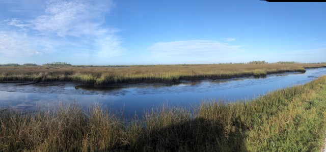
North of Port Richey, the western edge of Florida gets thick with trees and rises to a whopping 20-25 feet above sea level. The trees are mixed hardwood and pine with the iconic live oaks playing a role as well. US 19 is a good road and seemingly out of nowhere, the people stop. Mile after mile, the landscape flows by, the Gulf of Mexico stays to the west and thick forests rise to block it out. Gone is the bright sunshine and sparkling vista, in its place is a cool, slow, green shaded ecosystem that really could be anywhere. The periodic towns are small and simple and to the point. Each one has a single road to the west, through the trees, to a coast — where there is another small village, that is simple and to the point. This, it seems to me, is old Florida.

I don’t really understand the sudden lack of people clamoring for a spot on the edge here, though getting out on Pine Island for a look around helped me figure some things out. To begin with, there isn’t much edge to hang on to at the coast. The forest ends at the salt line and marshes of sawgrass and mangrove fill the space pretty much to the Gulf’s edge. What space there is, rather then being sugar white sand, is more rock and silt. Some towns and homeowners have created beaches with low walls to hold in the sand. So you get the effect of the beach — until you go to frolic in the surf — of which there is none. There is a massive salt flat here that runs waaaaaay out into the Gulf. The bottom is silty and shallow and thick with vegetation. And marine life. Dolphins puff as their slick backs break the calm surface and they grab another breath. Blue Crabs, big ones, scuttle from one clump of grass to the other. Fish of all sorts do their thing as well. The water is crystal clear, but this is an edge for fishing.
Several rivers find the Gulf here, most famously the Crystal River and the Suwannee River. They run slow through the cypress and look black, though they too are gin clear. The manatees lumber into the warm water and eat the marine vegetation and in some places tolerate a lot of people who come to swim with them. But the coast is apparently not beachy enough to attract the hordes. This, today, was to my everlasting benefit.

I loved this part of Florida’s western edge. It was the tonic I needed after so much development. I expect it is going to stay this way because, in addition to the lack of beachiness, there is also, apparently, a sinkhole issue. Oh, and a nuclear power plant. At the tip of West Fort Island where the Crystal River empties into the Gulf, there is a tiny state park with a well maintained pier jutting out onto the flats. Extensive research here amongst the grizzled crabbers and bobber fishermen gave me some important information. It’s easy to fill a cooler with crab, even in November, and the fish bite stays pretty steady except at very low tide. The water quality is excellent and the power plant looming on the horizon to the east is no issue at all. But the sinkholes are a problem. Apparently the underground aquifers have a tendency to sneak around eroding the limestone and causing the ground to rather suddenly shift. I was told to never consider a house if the trees were turning brown around it. And to check all the grout lines in the tile. Because first, the vegetation dies and then the tile cracks and then house disappears. Now, these professors of the salt flats are not, by any means, data driven authorities — they said the red tide was caused by too many people in Miami eating beef and pork — but there were a half dozen of them, sort of a morning bait club, and they have collectively been here for 70 years or so. And that gives them standing. And on this bright, quiet morning, in this peaceful place on the edge, facts were less important than the historical reality of a last, best, unspoiled edge on the western coast of Florida. So I didn’t tell them about the Sahara sands and the algae. I just stood around and listened to the dolphins and the old men and stared at the Gulf.
Further north, the edge bends to the west, but remains relatively empty. The old US 19 highway strays a bit further from the coastline and the single roads leading west space out. And you enter the panhandle. The edge is to my south now and the beachiness returns and with it the people. But it is a slower, less frenzied sort of development. And today, it is the beginning of a horror show.
I crossed the Ochlockonee Bay on highway 98, just east of Carabelle, Florida, and began to notice the piles of debris on the sides of the highway. Not big ones, but neat bundles of sticks and muck and the odd pine tress bucked in to chunks. This was the beginning and from then until Panama City, the edge became a progressively worse hellscape of one of the most daunting aspects of living on the edge.
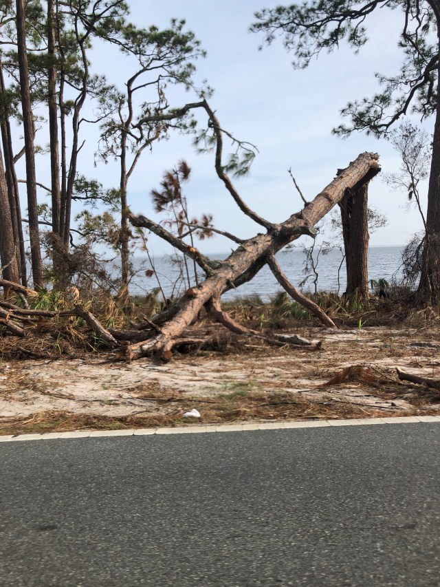
Hurricane Michael came ashore as the third most powerful hurricane on record — a category 4 storm with winds of 155 mph and a bottomless low pressure. The center hit Mexico beach, well to my west. What the storm did to the edge is unimaginable. I would not photograph the personal property damage — it felt too invasive to me — but I will tell you it is so overwhelming I don’t know how they even start to recover from it. Trees, ancient trees three feet across at the base, are rent and tossed in a pick up stick puzzle that covers roads and houses, litters the shoreline and buckles the ground. In places east of Apalachicola, the road was lifted up and folded over, upside down, onto the northern side. And in other places, there is no damage at all. The randomness of it makes it all the more horrifying. The extent, miles and miles and miles of it, makes it seem unconquerable.
And that’s really it. The edge and all its beauty is exposed to the whims of a power that we do not know. Until we do. In many places on my long journey, the edge has always felt capable of powerful change — there were mudslides in California, I even watched one — but no where was that sense of impending risk made this real. Here it is. And it is more than my brain can handle — I don’t have a place to put this sort of catastrophe in it. Is it the price you pay for living on the edge? Is it a stroke of horrible luck? Is it a reckoning for hubris? In the end, exhausted, I settled for it just being the edge. And I took heart in the reaction.
Everywhere people are steadily doing what needs to be done. There is a system — people gather debris and pile it at the roadside, lines of trucks are loaded with it by excavators that creep along from one pile to the next and lift it into the trucks. Tarps are tied, and businesses announce open status with spray painted bedsheets. FEMA is everywhere with camps of workers and centers for relief aid. Samaritan’s Purse 18 wheelers are parked at churches caring for the stricken. Hot dog stands provide free food and ice. And in Port Saint Joe, every new telephone pole along the highway sports a crisp, new, American Flag. This edge is going to clean up, and people are going to remain here, and businesses are going to keep doing business. It will, of course, never be the same. But it will be again. I believe it will take several years to get to that point, but it will happen.
Mercifully, Highway 98 is closed to all but authorized traffic just west of Port Saint Joe. Mexico beach, ground zero, still has too much work to do for passers by to clog it up. I had to head inland before turning south to enter Panama City and regain the edge. It took an hour and half to get through Panama City — over a distance of about 20 miles. The trees here were bigger, the population and building more dense, and the streets narrower. With the piles of debris, it was basically one lane for much of the residential sections. Then I crossed the bridge at St. Andrews Bay and everything returned to normal. I’m 16 miles away in a friend’s place between Rosemary Beach and Alys Beach, and life is completely, totally, normal.
Tomorrow I take a short run to Mobile to visit old friends and, more importantly, to receive the gift of a lifetime. Russell Ladd has forgotten more than most will ever know about the Mobile Tennsaw River Delta — an ecosystem so diverse and special it is often called America’s Amazon — and he is going to show me around it. I will spend part of Thursday with him in the delta. I can hardly wait.

There is nothing finer that a day in Chuckfee with Captain Ladd.
LikeLike