Holding the Edge

Morning Commute

Rather than waking up this morning anxious to see new things, I awoke only wanting to spend more time in the trees of the Humboldt Redwoods. So, happily, my morning commute as it were, started with about 24 more miles of them as I followed the Avenue of the Giants north to its terminus at the 101. They played their role as stately sentries guarding close the shoulders of the road, and I played mine as deeply awed interloper.  It was a great way to start a day.

The 101 basically follows the coastline from here to the Olympic Penninsula, so there isn’t much route finding to do.  Oddly, unlike the areas further south on the western edge, there are many times up here where the ocean may be only a couple of hundred yards off to the west, yet there is no evidence of it.  So deeply wooded and steeply graded is the topography that the sense of being near the ocean is often completely absent.

The first change comes at Humboldt Bay, and it is equally surprising.  Thanks largely to the Elk and Eureka Slough Rivers, a broad alluvial plain begins about 2 miles east of Humboldt Bay.  This means that when you top the last ridge to the south and get a view of it, it looks like, well, it looks like anywhere on the Gulf Coast.  A wide open, flat, marshland dotted with shorebirds and waterfowl and criss-crossed with the remnants of each river now ebbing and flowing with the tides.  The bay itself is as calm as an evening bath.  Nothing at all like the raging torrent I’ve grown accustomed to. With a great long sweep, the 101 follows the bay around to the east and back north and west where you get a sense it’s all coming to an end.  The northern end of the bay is a sheer wall of dense redwood that must be switchbacked to ascend.  North of the bay, the old Pacific is back, spoiling for a fight.  This time, however, there is a new ally for our besieged western edge.

Stomping like so many Goliaths right to the shoreline are the redwoods. Having planted themselves they now need this ground to survive, so this battle is personal.  All along the way to Redwoods National Park the ocean seems to realize the game has changed.  Gone are the washouts and cliff faces and in their place is a steady truce — the ocean is no less powerful, but that power seems to have decided not to show off quite so much.  

At Redwoods National Park (or really National and State Parks, as this is a series of connected parcels of protection that have various controlling entities) I swing by to meet with the Ranger and decide what to do. First thing, the main road — basically the only road — through the center of the park is closed.  Completely.  Not because of a mudslide or a upheaval or anything like that.  It’s closed because on the giants, my old and proud sentries, fell.  Across the road. When one of the tallest trees in the world falls, all sorts of stuff goes wrong.  They’ve been weeks trying to get the section covering the road cut out and expect to be more trying to make a road out what is no doubt now a deep trench where it fell.

A little sunlight goes a long way deep in the redwoods

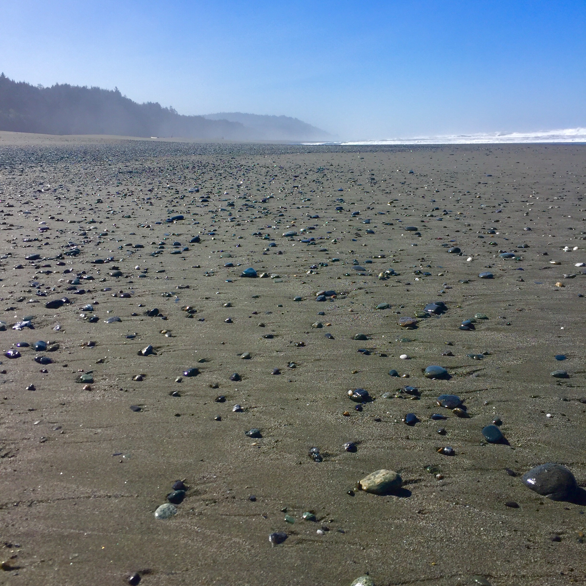
With many of my options precluded, I elect to follow a narrow, rutted, almost impassable road over the ridge, through a state wilderness area, and out to a beach called Gold Bluffs.  Here I find a minor victory for the edge. The 250 foot or so bluffs were clearly taking a pounding, they are sheer and slides are frequent.  But with redwoods growing right to edge — and sometimes over it as young ones sprout in the slides — the edge won. A thousand yards from the base of the bluffs if the ocean, peacefully polishing stones deposited by all the nearby rivers and depositing them back out on the broad, long, beach.  In place of the once crashing surf at the base of the bluffs is a thriving dune system of marine grasses and conifer shrub.  There are elk from the Roosevelt Elk herd that graze here and the edge is firmly re-established.

Gold Bluffs Beach

As I ride further north tomorrow, we will see if it can hold.

The Gold Bluffs

The Edge of Destruction and the Peace of Power

It’s a daily, beautiful, battle out on the western edge

I’ve been in Napa for a day to see an old friend.  Sometimes you need to see someone and you find a way to make that happen, no matter what sort of crazy journey you are on.  I’m glad I did.  Napa is a peaceful place, and I had a wonderful evening and day with my friend and his family.  Today, I left to the north, through Calistoga to Porter Creek, which I followed until it hit the Russian River, which I followed until it hit the Pacific Ocean.  From Stewart’s Point to just south of Fort Bragg, I travelled the “1” again.  I thought it might get old, this road of 10,000 post cards, but it doesn’t.  With near continual elevation changes and flora from deep forest to open pasture, there is a new frame around each bend for each new view.

It is, however, a place of almost frightening raw power.  To ride the “1” is to witness the battle of natural forces — the relentlessly pounding Pacific versus the proudly defiant rock walls of the continent, and the third player in the game; the water from the east.  While the shoreline has it backed bowed against the ocean, that same back is turned to the eastern mountains, where rain and snow — prodigious this year — land and begin a headlong rush downhill to the sea.  Everyone knows it is hard to hold back anything if you don’t have good footing, and this year, footing for the coastline is sketchy.  The erosive eastern tide of snowmelt and rainwater is washing out chunks of the coastline, and the “1” with it.  We, or at last I, am conditioned to respect the power of the crashing surf — it shakes the ground when you stand on the rocks to to take a picture of it — but the rain and snow seem more docile.  Not so here on the western edge.

Forced off the “1” I cross over the mountains via Route 20 and turn north again on the 101, which will join the “1” at Legget and continue from there to Olympic National Park in Washington.  Everyone out here calls roads by the word “the” and then the number, I don’t know why.  Anyway, the 101 takes me to Humboldt Redwoods State Park, via a scenic offshoot called Avenue of the Giants. 

Avenue of the Giants

The thing about Humboldt Redwoods is that it is the largest old growth redwood forest in the world. In the world.  And while these coast redwoods are not the oldest trees on the earth, or even in the US, they are the tallest.  Age is more an honor than a contest, however, and these trees have the honor of being around since before Christ, at least a few of them do.  I take two different hikes today through two different sections of the Rockefeller Forest in the wilderness section of the park.  On the ground, amongst these giants it is deeply peaceful. Coins in your pocket seem an intrusion as you walk along.  Their power is one of permanence.  As soon as you are about to be awed by the tallest redwood in the world (which I was, it is 361 feet tall and over 53 feet around) you realize that size is not nearly as important as staying power.  And this joker has staying power.  While the coastline was breaking off in chunks, many of these trees were enduring lightening strikes, floods and sawyers’ blades, only to refute them all and stand tall.  Stately, quiet, power.

Lower Bull Creek Area, Rockefeller Forest

I will move on up the coast tomorrow to Redwoods National Park, where I will see more, but not taller redwoods.  I hope to camp on the beach there. Like the rugged violent coastline, I don’t expect the presence of more redwoods to get old. I feel better when I’m around them.  I feel more certain about our future.

The Western Edge

Seen in the distance, Ragged Point marked the spot where the road was closed

California Highway 1 is pretty much the epitome of what it means to travel on the edge. Planted and paved in a narrow space between the surging Pacific Ocean and the cliffs of the stubborn continent, it is literally and figuratively, the edge.  And you can drive on it.

Having spent restful night tucked in a cove behind Montana de Oro itself, amidst fir and Eucalyptus that hissed in the ocean wind, I awoke to ride the “1” north. The plan was to make it San Francisco and then turn inland for two days in Napa to re-charge, wash some clothes and see an old friend. Plans on the edge, as I know by now, rarely survive in tact. It turns out that Highway 1 is very nearly washed away between basically Hearst Castle around San Simeon and just south of Monterey. I drive to the spot of the closure where, by happy accident, I get to see a colony of Elephant Seals before turning back to find a route inland around the damage.  Among their many charms, Elephant Seals spend most of March and early April lying on the beach blowing snot out of their noses and shedding all their hair. The molted hair and skin leaves a piquant odor in the air and provides an all you can eat buffet for the noisy seagulls.  There are several hundred seals flopped up on the beach itching and snorting.  The males grow to 5,000 pounds and are 16 feet long. The females are a svelt 1,800 pounds and 12 feet long.  Not even including the juveniles you can begin to get a sense for the amount of hair and skin we are talking about. Educational, yes, and an interesting thing to check off the bucket list, but at this time of year at least, unpleasant.

The Elephant Seals of San Simeon are generally unconcerned about what we think of them

So as it turns out, the rugged western edge is a fragile thing. A continent unmotivated to cede its ground and a sea determined to take it away. Add in a year of record rains, a good portion of which having hit the ground wants very badly to run to the sea and the edge is getting it from both sides.  The combination has proved too much this year and the mudslides and road collapses have forced an alteration to my plans.  I weave my way back over the coastal range and find suitable route north as far as necessary to rejoin Highway 1.  The same rains that have washed out the highway on the edge have fueled a spectacular outbreak of fertility on the eastern side of the coastal range.  The broad green valley, already known for its vegetable production is chock-a-block with new growth and every grower and farmhand is wearing a smile.  I think about the early settlers here as I drive along.  Some saw the coastal range and thought, just one more time we will see what’s on the other side.  Others saw the fertile valley on the eastern side and, after weeks in the desert, said this is where we will settle. And there they did, ultimately producing the bulk of an entire nation’s fruit and vegetables.  The other group crossed one more range only to damn near fall into the sea.  But there they settled also, hanging towns in the narrow gaps in the cliffs and exercising all manner of engineering to cantilever and prop up what soon became centers of fishing and financial and technological industries.  With the ocean as a backdrop and no plows to push, the western edge became the more popular and the required development pushed further still the boundaries of what one can and can’t do to a terrain to establish a home.  Periodically, we are reminded when we pushed too far — and the land simply takes it back. Whether through a shifting of the ground itself, or the sloughing off of hillsides under the weight of heavy rains.

Atop the coastal range looking west

Such is the beauty of this rugged edge that, regardless of the risks and penalties, we simply call in the big machines and start again.  California will re-open the lost sections of the Highway 1, edging them a bit closer into the cliffs, supporting them a bit more strongly with engineeried devices.  And one day, the land will take those back too.  Man decided the northern and most of the southern edge of our country, but nature created the western one.  And it’s not inclined to have its choices altered. And so the struggle continues out here on the edge.

From Mojave to the Sea

West on the Mojave Road

At some point in the history of North America, the Mojave Indians forged a series of trails from their homes in the Mojave region to the Pacific Ocean.  This allowed trade with other tribes, and gave them a chance to get out of the arid desert region of southeastern California, traverse the mountains and explore the new terrain of the coast.  It enabled them to find the edge. And it allowed them to return home, richer and more informed, and perhaps more appreciative of the very special place that is the Mojave.  The Spanish Missionary Francisco Garces followed their tracks sometime later and made the same journey, and, in 1826, Jedidiah Smith became the first white man to follow this path and reach the Pacific overland from mid-America.  Today, along the exact same route, tested at times by the terrain, I left the Mojave and headed west to, as Jedidiah did, reach they Pacific from mid-America.

While I would be much aided by modern conveniences and roadways, for the first four hours, I followed his route — the route of the Mojave.  A simple two-track path out of the New York Mountains, across the lava fields and groves of Joshua trees, at a pace of around 10 miles an hour.  Where I travelled, they had travelled, where I went, they had lead. I saw one other traveler the entire route before arriving at a paved road and making my way to Baker California and from there onward to the coast.  I spend a fair amount of time appreciating the land over which I travel, but I don’t, I think, spend enough time realize how it is and why it is I am able to travel it.  Other people, for other reasons, with greater burdens than mine, found it, settled it, mapped it, routed through it and made it a way forward.  Today, amazed by all that I saw, I took a minute to think about them and to offer some measure of gratitude for my path to the edge.

At Baker California I was reminded of a quote my son recently sent me.  I can’t vouch for the attribution, but I believe it.  The quote is, or is close to, “Men argue, nature acts,” and it is attributed to Voltaire.  In Baker, nature acted.  50 mph constant straight line winds blew out of the west and scattered sand, dust and soda from the dry lake at Mojave in an apocalyptic scene of chaos.  Men and women scattered as well, from one lane to another in fist-shaking rage at all around us.  I tried, vainly in some cases, to focus on progress and to remember previous travelers and their hardships. And I kept my focus where their’s no doubt was — on progress to the sea.

With only a little slacking of the wind, I crossed the nation’s fruit basket between Bakersfield and Mojave, mesmerized and appreciative of the rows of almond and fruit trees.  I thought about the massive irrigation that kept them growing with water from the Colorado, and I thought about the signs posted saying “no water = no jobs.” And I thought about Voltaire.  This year, after many years without, nature is acting in abundance when it comes to water.  Not since 1983 have we seen this depth of snow pack that fuels the Colorado and other rivers that provide the water that grow our fruit. While we are arguing over who owns what water and what causes it to be more or less in abundance, nature is raining and snowing like we haven’t seen in years.  I don’t know why.

What I do know is that from Mojave along the Smooth road to Paso Robles, the result is as obvious as it is glorious.  The land is green.  In row after row of hills as large and smooth as great pachyderms’ backs, the grass is tall and green and lush.  In years of similar cycles the Mojave Indians making this trek must have thought they’d arrived in some paradise, as different from their homes as night is from day.  They knew very little of other places, but by comparison, my experience is vast, and I have not seen ground and terrain as beautiful in any place. I wonder if it will be this way next year, in any years hence, and I decide that it has been before and it will be again. To think otherwise is to project a dominion over this land that I simply do not believe we possess.

Closer to Paso Robles the great beasts of hills give way to slower rolling ground transected by the the geometry of vineyards.  The rhythm of the vine rows and stakes carries a tune as you pass along before the city intrudes. There is some sense of a terminus, but no evidence of one as I drop through the valley of the National Forest just south of Los Osos, draped with gum and Eucalyptus, hidden and dark and peaceful.  And then it happens.  The great ocean fills the scene as far and as wide as any author has ever described.  The edge.

Here at Montana de Oro I am at the western edge.  An edge that is so only grudgingly.  A land that fought and fights to continue.  Jagged and raw it cedes only to the power of thousands of miles of hydraulic force born in Asia and stenghthed with every swell until it breaks this landmass off at the Pacific cost.  This is an edge wrought not by men, but by nature.  This is as far as we could push, as far as we could dream.  To here we could travel, from here we could trade, but we could not make more land, we could not will more opportunity.  From this western edge, we would stand, turn eastward and realize that we now knew the extent of our country.  But we would have to make it one. And so we have.

Sunset at the Western Edge

Tomorrow, I follow this edge north. To learn more of who and what made the travel possible, and to learn more of what it means to know limits — and how to make the most of them.

Into the Mojave


An early start out of western New Mexico meant I could cross Arizona, a corner of Nevada and make it to the northeastern edge of the Mojave National Reserve by one o’clock.  The getting here was one of those legs of a trip that this that happen when distance needs to be covered — straight, unremarkable, 10 and 2 on the wheel and keep your mind on the objective.  I am not, generally speaking a fan of central Arizona.  So I pointed the big landcruiser west and focused on the task at hand.
Rewards come in all shapes and sizes, and mine today is in the form of a remarkable piece of our country, biologically diverse, starkly beautiful and utterly alone in a corner of California — The Mojave.  My approach from the northeast was intentional; I planned to drop in via the Ivanpah Road and follow it south to the southern edge of the New York Mountain range, and from there take the New York Mountain Road to the entrance of Carothers Canyon.  Basically all of the roads in the Mojave, other than  four or so main ones are narrow two-tracks that alternate between soft sand and teeth-jarring rock  corrugations.  After a brief stop to air down the tires in the hopes of preserving my fillings, I found the ride to be extraordinary.  Once again, I found that being in a place, really in it like you are when the track is as wide as the car and no one else is around and the scenery wraps itself around you, deepens your appreciation for all of its aspects.  The wildness, the harshness, the beauty, the scope.  Progress is slowed to a manageable, safe pace of around 10 mph, and frequently the terrain forces you stop, assess, plan a route and work your way through obstacles. 


It is tempting the think of the Mojave from afar, as a desert.  While there are portions that match that cliche, most of it is a varied environment both beautiful and surprising.  Caruthers Canyon is broad u-shaped canyon at 5,400 feet of elevation the walls of which are the southwestern peaks and ridge lines of the New York Mountains.  Camped hard against the absolute head of the canyon, with a 7,500 foot mountain on the southwest rim I am amidst pinyon pine, at least three different varieties of cacti, juniper, desert wildflowers and sage.  A few yards from camp a seep spring moistens the head of a wet water creek that, by all evidence, runs rough and wild out the canyon when the rains are present.  The camp is tracked by deer, coyote and lynx tracks and it is as remote and unviolated as you can possibly imagine.  Certainly others have been here, both recently and over the years, but such is the Mojave that the only proof lies in the sandy two-track 4×4 road you must navigate to get here. It is a special place.

Tomorrow I will leave it and I wil reach the edge on the Pacific Coast at Montana de Oro.  But first, I will leave this canyon and find the old Mojave Road, following the same track it has since it originated, and follow it west to the western edge of the Mojave and into Baker California. I am anxious to get to the edge again, but I will carry Caruthers Canyon with me always. It is more than just a stop on the way to the edge.  It brought me into the Mojave.

The Edge of the Plains, The Edge of the Mountains

Bring me men to match my mountains

Bring me men to match my plains

Men with empires in their purpose

And new eras in their brains

–Sam Walter Foss, The Coming American

In the early pre-dawn of the Cimarron national Grasslands, with the coyotes making their last rounds, singing before they slunk to their dens for the day, I stood and watched the curtain of light unfold across an ever clouding sky.  The grasslands, the plains of the southwestern corner of Kansas were awakening; and they appeared to be angry.  As passengers on wagons along the Santa Fe Trail awoke on mornings like this they added another fear to the list of many — weather. Regardless of preparations or guile, of planning or purpose, this land decides what will happen at any given moment.  And today, it would decide for me.

The Cimarron River as it flows above ground through Cimarron Canyon

From the southernmost corner of what many regard as the greatest Indian empire ever assembled — that of the Oglala Sioux Chief Red Cloud — I set out to follow the Santa Fe Trail into northern New Mexico.  Red Cloud was a plains Indian at heart and was largely afraid of mountains, preferring to use the low hills of the front range for religious ceremonies and stick to the grasslands.  You could see people coming from a long way away on the plains and, if you were as ruthless as Red Cloud, you could build an empire there.  With hands bloodied with the lives of other tribesmen and white men alike, he did just that. And as I rolled up the Cimarron Canyon and over the mountains of Taos Pines, I found some wisdom in sticking to the prairies.

The grade and terrain of the mountains ground my progress to a slow crawl and the pounding snowstorm threatened forward progress at all.  I imagined Red Cloud sitting on Point of Rocks watching the plains and enjoying the satisfaction of ruling a land he knew, could predict and could manage.  But I also thought of the people moving west, people who thought of a new era, people who viewed hardship as investment rather than omen. And so on I climbed, up and over the mountains of Ponderosa and Lodgepole pine, across the broad saddles dotted with high lakes, and down to Santa Fe.  From there I followed an old friend.

Last Fall I spent a couple of weeks riding the southern edge from the Gulf of Mexico to the Pacific, and for most of the entire trip, I had the Rio Grande river on my left shoulder.  Today, after falling out of Colorado and gaining strength from tributaries in northern New Mexico, the Rio Grande was back, but this time, on my right shoulder. From Taos down through Santa Fe, the river led me out to the carved sandstone buttes and Mesas of central New Mexico and then bid farewell at Albuquerque as it turned south and east to the southern edge.  I continued west to the New Mexico Arizona border where, after 10 1/2 hours at the wheel, I stopped.  Tomorrow I will, as others before have done, continue west and cross the Mojave Desert, pushing to the Pacific again.  Pushing to the edge.

My old friend, The Rio Grande, now on my right shoulder leading me south

From men like Red Cloud who built empires on the plains, to others who conquered the mountains in search of a new era, there has been one constant.  The land alters us.  It changes plans, it gives sustenance, it takes away will.  In the end, the old ways of fear and bloodshed were replaced — with the help of the land — with a single, united piece of ground linking cultures, topography, families and foes, from east to west, north to south, into an unbreakable chain of liberty.  Liberty birthed in the east, manifested and sustained by the sacrifices made pushing west, and matured by the certainty of common dependence.  We didn’t build an empire after all.  We built a nation.

But we had to get to the western edge to start knitting it all together.  And I have a ways to go yet.

The Edge of a Journey

In the early 1820s, travelers headed west would often find themselves on the Santa Fe Trail as a means to get there.  From Missouri, across Kansas, Colorado and into New Mexico.  The trail crossed the great grassland prairies before rising into the mountains of northern New Mexico.  Today, I started my journey the same way — Missouri, into Kansas along much of the same route.  The old travelers were on the edge of something remarkable and life changing.  I think I am too.

Around 10 o’clock last night after a very nice first day, the sky lit up and put on a lightening show non-stop for six hours.  I lulled to sleep to the sound of the rain and the distant thunder and roused periodically to the bright flashes, and I don’t remember ever worrying about anything. It was, if there is such a thing, as peaceful a thunderstorm as you could imagine. This morning, rain still falling, I got the camp buttoned up and headed west into Kansas wondering why I didn’t worry.  And then wondering why I was wondering about not worrying. I was headed for the Cimarron National Grassland, a place I’d never been and I decided that I must have just replaced worry with wonder.

The Cimarron National Grassland is one of 20 National Grasslands administered by the Forest Service and is over 108,000 acres of land in total.  The Santa Fe Trail runs for 23 miles of its length through the middle of Cimarron as does the Cimarron River, more on which later.  Rather than finding rolling fields of tall prairie grasses, I found rolling hills of, well, I don’t really what.  There is cactus, sage, certainly some grasses, and the low areas are dotted with cottonwood trees. And there is horizon to horizon a constancy of rhythm to it that it takes your breath away.  The idea that one lone point of rock was so important as a navigation point is testament to the sameness of it all.  Called, appropriately, Point of Rocks, it was a point from which one could see other travelers in the distance, or by which one could navigate along the trail.  Everything else, everything, is the same.  Through this all runs the Cimarron River, though “through” is not the right word.  Under is the right word.  If you look on a map you will see the Cimarron River.  If you come here to it, you will not.  It runs under the grasslands.  As a result, you can only identify it by the cottonwood trees along the shallow depression where one presumes it sometimes rises to make an appearance.


Amidst all this vastness, I find a campsite along the Bank of the not a river and within hours am surrounded by yipping coyotes, various raptors and Merriam turkey.  This is before the stars show up.  When that happens the whole notion of vast takes on a new meaning.  With no light pollution, crisp dry air, and nothing taller than your waist (Point of Rocks not withstanding), the night sky is a pallet of which only the Creator was worthy.  Mercury, Mars, star clusters, all the old favorite constellations explode in clarity and depth only possible when you get this far away from everything.  And somehow they mean more here.  They have a permanence and stewardship to and of this space, watchmen of travelers through this vastness, stenographers of a history that we only print in pages.

I’m not on the edge yet, but for many travelers in the past, this day’s journey was an edge.  They were leaping off.  Pressing on.  Going forward into what they knew not.  And these stars, and this grassland saw them on their way.  As they are each doing with me.  Much to my delight.

The Edge of Familiar

Since just after I was born, maybe a year or so, I have spent every formative moment of my life living east of the Mississippi River.  I grew up east of the river, went to college east of the river, fell in love east of the river, got married east of the river, fathered children east of the river, built a home east of the river.  Fitting then, that as I set out for my longest journey west of the river, that I should start essentially where I began — at my parents home in the town where I grew up.  I haven’t lived at home for 30 odd years or so, but every doorknob, floor creak and cabinet latch remains utterly familiar.  I can navigate the house and grounds in the dark, as if the house somehow imprinted itself into my eyes all those years ago. I’m glad I started out from the big house on the hill.

Out of the driveway, my first few hours was also a drive I could probably made with my eyes closed, or at least half closed. Countless pre-dawn trips up HWY 412 to the duck lease make the road a talisman for me.  It wass the beginning of something i loved and tried to be good at, the beginning of a exciting time away from things which we couldn’t really control.  And it will be so for me today.

Across the last wrinkles of the New Madrid fault, the landscape finally gives way — after towns called Alamo and Bells, Friendship and Fowlkes, Tigrett and Dyersburg — to the alluvial plain of the Obion and the Mississippi.  Atop the last fold jammed skyward, I suspect, when the New Madrid ripped a hole on the northwest Tennessee border called Reelfoot lake that was big enough to make the Old Man River himself flow backwards to fill it, I get the first of many vistas to the west, the uninterrupted horizon re-ordered lower and broader.  It seems as if there is no end to how far you can go.  Fresh on the other side, Missouri begins rolling and rising to the Ozarks and I am again in the wooded hills of the familiar.

I think I read somewhere that north west Arkansas and southern Missouri are hotbeds for retirees, and I can see the allure. It is really beautiful country.  The terrain is varied and lush.  The rivers are fast and attractive and plentiful.  The depth of the pasture land seems a pretty good indicator that there is an aquifer underground here.

That supposition is supported at Roaring River State Park.  Here, said aquifer decided it was time for a little fresh air and jammed its way through the granite via Roaring River Spring where it dumps 20 million gallons of fresh, cold water on the ground every day.  A businessman from St. Louis bought 2,400 acres on the courthouse steps in 1928 and turned around a few days later and gave the whole thing to the state of Missouri for a park.  The state knew a good thing when it got handed it and built a very well executed trout hatchery tight where the water comes out of the ground, supplying plentiful (and huge) trout throughout the river.  They release fish every day, I think.  It was my plan to catch one of the submarine-sized trout you can stand on the bank and watch patrolling around.  I didn’t.  But I did have a massively relaxing few hours trying.  Watching the wizened old verterans turn and slide up to my fly pattern, bumping it with their nose before slipping back into their comfortable spot to wait for the real thing.  The park is very popular and unless you can get in your zen on a small stretch of water and ignore all the commotion, I wouldn’t recommend it.  But I have a camping spot next to the river — which is indeed roaring — and the spaces all around me are empty.  So there is that.

I have a long way to go to the edge, but today I made a start. I’m heading west.  Across the great grassland prairies, through the Rockies and San Juans, across the Mojave, and through the Sierra foothills to the coast.  There is nothing like getting started.  Soon I will strike the western edge at Montana de Oro and from thence north all the way to the Straits of Juan de Fula.  None of it even sounds familiar to my ears. It sounds like the edge.

Returning to the Edge 2017

It’s time to go again.  Spring is in the air and the edge is on my mind.  I’m leaving in a couple of weeks.  This prep time is a confounding period of excitement, worry, and careful consideration of all potentialities. First on the list are a few vehicle additions. I’ve crafted a set of storage drawers for the truck that provide a nice level load platform and two big storage drawers, one for the kitchen and one for the tools/recovery gear.  This allows me to keep everything organized and out of the way while giving more usable space luggage and water.  I’ve also reached out (again) to the marvelous folks at Equipt1 Outfitters (www.equipt1.com) who supplied the K9 roof rack before the last trip.  This time I’ve purchased a new awning from them.  Gone is the old home made one which, while serviceable, was proving to be a pain in the butt to set up alone in the wind.  Arriving soon is the Eezi-Awn Bat Manta Swift.  Look for it in the photos from the road.  And do use Equipt1 anytime you need overloading gear.  They are the very definition of great service and great product.

Next, of course, is some sense of route.  I have to get back to the western edge, just north of Los Angeles to pick up where I left off and, on paper, this would be (another) long drive across the country via mostly I-20 and I-40.  I can’t bring myself to do that route again. So I’m going to head north and loop through the great grasslands before dropping diagonally across Nevada into Needles, CA and from there over to the coast.  It will take a little longer, but it will be different country.  I’m into that.  After that, the edge is pretty easy — or it would be if the Pacific Coast Highway wasn’t busy falling into the Pacific.  I will use it as much as I’m allowed, and venture inland when required.  One trip inland will be to see Pinnacles National Park, but other than that, I will hug the edge up California and Oregon and Washington camping mostly on the beaches of various state parks.  In Seattle I will pick up my son and we will visit Olympic National Park and maybe Ranier and Cascades before we are joined by the rest of the family for a little stay on Vashon Island.  After that, it’s a turn to the east, staying on the northern border as long as my stamina allows before diving south to home.

So, it’s time to snap the picket stake again and set off.  I hope you can join me via the nightly notes and photos I post.  For now, I will spend a couple weeks organizing and packing, with the siren of adventure ever in my ears.

5,310

I completed my most ambitious adventure to date after 5,310 miles.  From Atlanta to the southern edge where I last left it — at the west gate of Big Bend NP — and from there along the southern border to Imperial Beach, CA, and finally, up the western edge to Los Angeles, CA.  I turned inland a few times, most notably to Joshua Tree, NP and then to Coachella for a four day music festival, before returning to Laguna Niguel, CA and then heading home.  I was on the road for 19 days.

Continue reading “5,310”