

I decided to work my way to the west entrance of Big Bend via Balmorhea State Park, HWY 17, then HWY 118. I would reach the edge today, but I would see some things first.
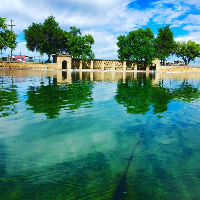
San Solomon Springs is the largest of several springs releasing a natural aquifer that gathers water from the Davis mountains and points deep underground to the west of Balmorhea. The springs filter this water up through limestone and sand and release it at a rate of 15 million gallons a day. Thanks to the Civilian Conservation Corps., this happens via the mission style concrete pool pictured above. Beginning in the late 20s and continuing through 1942, the CCC penned up the springs with a concrete coping enclosing almost 2 acres of water, and dug corresponding canals out of the enclosure to provide irrigation to the surrounding farmland. There is ample time and space to discuss whether penning up artesian waters that had been filling a natural cienaga and marshland area for tens of thousands of years is a worthwhile federal project, but that is for somewhere else. Today, there is a pool. And it is pretty remarkable I have to say. There is no “bottom” to the pool — meaning the workers just built the edging and left the bottom natural. The pool ranges to over 25 feet deep and it is chock full of fish. Which are easy to see because this is the clearest water you can imagine. Pick your adjective: gin, crystal, glass, whatever; it is clearer than that. There is nothing here other than the pool, so if you aren’t swimming, it’s hardly worth it. The water is about 74 degrees, so on a day like today when the air temp is 69, I passed.
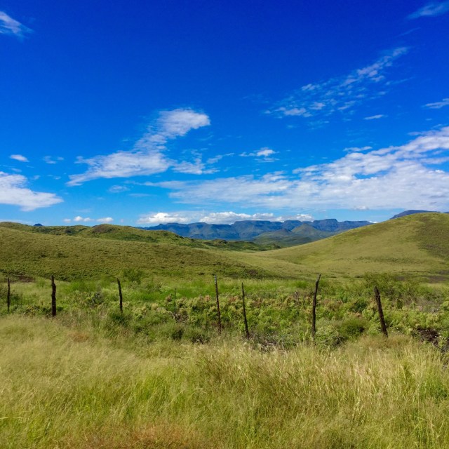
I keep making and remaking a list of “must drive” roads and, at least for now, HWY 17 between Balmorhea and Fort Davis goes on it. Different things motivate different people, but one thing that gets me going is a road that feels part of the landscape, that attaches you to your surroundings in a way that almost overwhelms you. HWY 17 is like that. Winding through the Davis Mountains the road is laid right on top of the ground, following the contours rather than making new ones. As it searches for a pass through the Mountains it carries you over and through rolling hills, deep canyons and around jagged stone peaks. By the time you finally get to a place you can get through the mountains, you feel almost in a trance, completely connected to your surroundings. And there, at Wild Rose Pass, the rust red canyon walls don’t so much rise as leap into the bluest of Texas skies. Be-columned by wind and rain they stand sentry over this amazing place, this landscape of extremes, and over us when we are in it.
I leave HWY 17 in Fort Davis and head into Big Bend National Park via HWY 118 through Alpine to Study Butte/Terlingua and in the back door (West end) of the park. It’s a great ride, but after the Davis Mountains it feels average. Once in the park the plan is to just skirt the edge and grab a spot to camp on the Rio Grande at Cottonwood Campground. That way I can get out early in the morning and keep heading west along the river. I take the Old Maverick Road just inside the park’s west entrance rather than following the main park road. This will save a little time and it’s the last road Foster and I took when we left the park in March. Basically, it is (or was) a corrugated gravel road with a few dry washes that will rattle your teeth a little, but it will also force you to slope down and look around and get up close. Well, alot has changed since March. It’s been wet down here and the road is a mess; the washes are rutted and in some cases still wet, and the corrugations are much worse due to the erosion. Nothing to do but take the tire pressures down and ease along. In the end it was enjoyable, included some great views, and got me to Cottonwood Campground and, at last, the actual edge.

Cottonwood is a great spot. It’s right on the Rio Grande and has, as one would gather, large, old cottonwood trees providing shade to many of the spots. It’s also empty. Buoyed by this and properly warned not to engage “Mexican Nationals” who may or may not approach me across the river, I pick a spot. But there is a problem. All the rain that made Old Maverick Road such a mess has also turned Cottonwood Campground into a petri dish of every insect from either bordering country and in addition to providing shade, the old trees are raining ants. It’s apocalyptic — I can’t even unload the truck without stopping to smash a dozen or so crawling all over me. And did I mention it is roasting hot? So, as often happens when you are around me, I change my mind. Close up and head for the high ground and the only place in Big Bend where I haven’t spent a night — Chisos Basin Campground. I will make up the time tomorrow.
The change works. I arrive at the campground (at 5,000 feet) too a cool 65 degrees and have time to set up and watch the sunset. The campground is crowded, but subdued, and the location down in the crown of the basin is beautiful. Temperature drops to the high 40s after dark, the stars and indescribable and I sleep well. The edge is doing me some favors. Tomorrow I will head out to the west, visit Big Bend Ranch State Park to follow the Rio Grande as far as roads will allow before heading north to Marfa for the night. Having reached the edge, I will ride it for a bit and then be forced away yet again only to regain it further west.
