Somehow my body clock has stayed on east coast time this whole trip. I don’t know why, but it means I get up at about 4 am every morning. Driving at dark kind of defeats the purpose of all this, so I find ways to use the time and then get on the road at sunrise — which is usually around 6:30. So this morning at 5 am in Gila Bend, I was up and reading the news when it sounded like someone suddenly started emptying a horse trough on the roof. It’s raining. In the desert. At 5 am.
15 minutes later, it stops, completely and immediately. Within about 15 more minutes, it’s as if it never happened. The streets are dry, the sky is clear. This sequence repeats three more times before 7 am. At home, and everywhere else I’ve been in a rainstorm, there is some kind of build up, a swirling wind, sprinkles before showers before storms, etc. And after the rain, it feels wet for a long time. Out here in the desert at present, a low pressure system to the north and west is drawing up moisture from Mexico and when it gets to the cool dry desert air in the morning and in the evening, this happens. But this doesn’t happen much. This entire area, from southwest Arizona, all the way to the Vallecito Mountains east of Sandiego is the Imperial Valley and was historically the among the driest places in the country.
I drive west out of the rain cells and am quickly crossing the border into California. Basically it’s Interstate 8 along the north edge of the Goldwater air force range, then through Yuma and right down on the border with Mexico from there to Jacumba and up and over the mountains into San Diego (in my case Imperial beach). Simple.
Most of the ground I cover early in the morning is massively agricultural. This is a shock to me. This is a desert. And yet, hay fields spread for acre upon acre. Perfectly crafted rice fields — so flat they can be diked for flooding with a hand trowel. Straight, long rows of freshly planted vegetables. This is nuts. Shortly after Yuma the Imperial Sand Dunes rise gently into the pale California sky. The color of dirty peaches, dimpled by the wind and criss-crossed with power lines and dune buggy tracks, they don’t seem “imperial.” BUt they seem alot more like the desert than agriculture fields. But there, righ through the middle of the dunes, I get the answer.
Just to the north of the road, a bright blue vein of water. Perfectly coped in shining white concrete, traveling at 5 1/2 miles an hour, and moving more than 26,000 cubic feet of water per second, is the All American Canal. And those hay field sprinklers, rice field irrigation ditches and vegetable patch water hoses are among the 630,000 acres of previously the driest land in the country that this canal now makes among the most fertile.
Authorized along with the Hoover Dam, the All American Canal is the largest irrigation canal in the world. The water is stolen, sorry, diverted, from the Colorado River about 30 miles north of Yuma via the Imperial Diversion Dam. It flows down across the southeastern corner of California to the Mexican border where it turns due west and continues along the border just past Calexico by which time it is spent. On a map, you see two rivers that look like they are flowing into the area out of the Salton Sea — the New River and the Alamo River — but they are going the other way. They are draining the runoff after the irrigation is provided from the Colorado into the Salton Sea. There is so much water moving into the desert from the All American American Canal, that it was leaking out through the bottom sufficiently to cause flooding in Mexico. Rather than raise alarm, the Mexicans figured out how to recover the water and use it for their own irrigation. Around 2006, California planned to line 32 miles of the canal to stop the leakage. The Mexicans sued, claiming the project violated its water rights. Seriously. The whole suit was rendered moot because the 2007 Tax Relief and Health Care Act included a rider requiring the project to go forward. California built a new section of canal next to the leaky part and diverted the water through it. You can’t make stuff like that up, but you can have an extra helping of veggies thanks to the All American Canal.
Just west of Plaster City with the Vallecito Mountains looming in the windshield, the interstate passes between two of the largest solar fields I’ve ever seen. Acres of black mirrors are angled east and tipped up to the sun. It was mildly terrifying — I kept fearing I would burst into flames like those birds on the internet. The elevation at the solar field is sea level. A mile or so further west, you start climbing — fast. But first, at the base of the mountains — our old friends the wind turbines are back, and this time some of the blades actually swing over the interstate. And for the record, there are no hawks in site. Water wars, solar panels and windmills — 50 or so miles into the Golden State and it’s like California said “hey give as few miles here to reinforce all those California stereotypes.” From the turbines you climb over 4,000 feet in an engine straining very few miles. There are barrels on the shoulder every miles with “radiator water.” This section of Interstate 8 is a designated scenic road, and I’m not aware of any other Interstate that shares that designation. Skirting the Anza-Borrego Desert State Park and running right through the CLeveland National Forest, I-8 earns the recognition.
40 miles from the coast and still at 4,000 feet, I start to wonder about the descent. You top out around the Campo Indian reservation (yes they are called reservations here and not nations — I don’t know why) where the tribe has put another dozen or so giant wind turbines on the ridge line — I don’t know if they are using them to power their casino there or selling the power or both, but I do see my theory about the turbines and birds shattered as a hawk sails lazily overhead. Never one to give up on a good sermon, I wish him well and tell him to rest in peace.
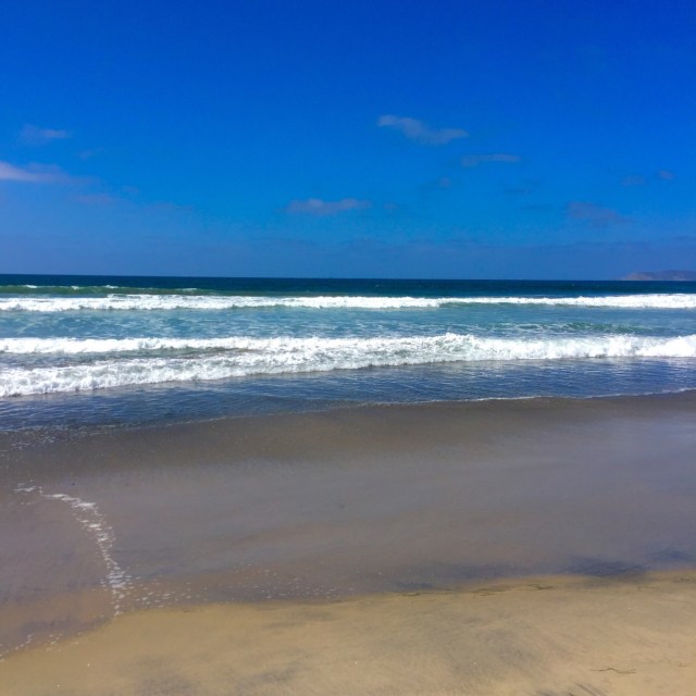
The decent turns out to be a 6% grade for 30-something miles. By the time I get to El Cajon, all the fun and games are over. The edge here is crowded, bossy and moving at far to high a speed. I turn up Wayze’s volume and pray she gets it right. I’m headed for the corner of the state, where the southern edge meets the western edge, at Imperial Beach. The final 15 miles is chaos. But I make it. I round the corner and continue on out to the Silver Strand west of Coronado Bay and San Diego Harbor. I park next to the beach, get out, and walk to the surf.
I feel like I should be able to tell you what it means to have completed a transit of the entire shared southern border of our country. Maybe I will be able to over the next few days. What I can tell you is what I did, standing there with my feet in the cold Pacific surf. I looked north. I’m replacing the silty Rio Grande for the blue Pacific as my partner on the left for the next leg of the edge and that means turning north. But that will be mostly for another trip. For now, I track the Pacific Coast Highway north only as far as San Juan Capistrano before turning east. Along the way, I pass the naval base where my grandfather trained for WW2 and the harbor from which he deployed and to which he returned. I feel good about seeing them.
I am through with the edge for now, and will spend a couple of days in Joshua Tree before my wife will join me near there for 4 days of wine, food and rock and roll. I expect I will have some better thoughts about this journey as I rest up in Joshua Tree, but until then, I leave you where I left the edge.