
The day really couldn’t have started off any better. From Kingman, all the way to Ash Fork, Arizona, old Route 66 was exactly as I had left it the day before. North out of Kingman it climbs through a canyon flanked by high bluffs that shade the morning sun. Through the towns of Hackberry and Valentine, still gaining altitude and still producing wonderfully framed views of canyon wall and sky, the route is relatively smooth and you can make good time. In Truxton, you begin to make the first topping out — the canyon walls spread out and the floor rises and you can feel the sense of space increase. By Peach Springs you are in the broad rolling grasslands of the Hulapai people. Shielded in the distance by high mesa walls, this open grassland, with a readily accessible aquifer, feels like exactly the sort of home these Indians would seek. I can imagine vast bufffalo herds on these grasses, and deer and other animals in the shallow draws. This is the Hulapai’s southern edge — they go all the way up to the Colorado river on the southern rim of the Grand Canyon, and they continue east all the way to the Coconino Plateau. What a piece of ground this is.
Along the way, the famous advertising campaign from the folks at Burma-shave makes its appearance. For those who are unfamiliar, it goes like this: small rectangular signs, placed about automobile height, appear evenly spaced about every 1/16 of a mile. Each sign has a verse of a poem on it, and the spacing sort of simultaneously helps with the rythym of the verse and holds your attention. The fifth sign says “Burma-shave.” There is a new poem every couple of miles. I am sure this helped pass the time on the journies along old Route 66 and the whimsical doggerel provides a subtle way to call attention to the product — even if it is a bit morbid at times. For instance:
Passing cars
When you can’t see
May get you a view
Of Eternity
Burma-shave
Or:
Although insured
Remember kiddo
They don’t pay you
They pay the widow
Burma-shave
Ouch. Finally, one of my favorites:
The angels who guard
You while you drive
Usually retire
At 65
Burma-shave
By this point I was thoroughly convinced my life was in danger and I desperately needed a can of shaving cream. But I read every sign — even the finale one — of every poem. That is advertising.
Further east toward Seligman, the ground flattens more, even as it gains altitude, and it could be west Texas — grass and sky for as far as you an see. No rocks, no trees. Except you are at 6,000 feet. At Seligman, just south of 7,000+ foot Trinity Mountain, it is clear the Mother Road is about to be over taken. With little space between it and I-40, it’s not a surprise when you lose Route 66 at Ash Fork.
I-40 feels as smooth as glass when you ramp on, and to be honest, it’s no less scenic a route here. You enter the southern unit of the Kaibab National Forest — still climbing — and the ponderosa pines make their appearance, black barked and imposing after so little tree cover. At Williams you wind around the northern base of 9,000+ Bill Williams mountain, and by the time you reach Flagstaff, you are in the southern shadow of Humphrey’s Peak which is the highest point in Arizona at 12,633 feet. I-40 doesn’t have a scenic designation here, or anywhere that I know of, but this is a beautiful drive.
At Flagstaff I start taking the exits marked “Historic Route 66” expecting that I will find, well, Route 66. Technically, I guess I do. Practically, what I find are little pieces — a mile or so — that run through a little burg of some sort in which I am assaulted with all manner of fake nostalgia, petrified wood, painted pottery, geode polishing, “squaw-made” Kuchina doll shops. I want to puke. Somehow poodle skirts and “ancient” indian artifacts served up with sno-cones and “roadhouse” burgers have become the raison detre of the Mother Road. If this is what it takes to keep the Mother Road alive, pull the plug on the respirator and let the poor woman go. It’s embarrassing. Surely this can’t be.
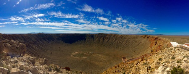
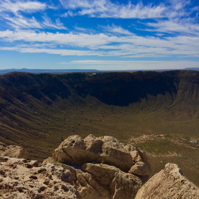
But it is. I fall for this nonsense over and over between Flagstaff and Winslow, when I finally call it quits. Instead, I go see a meteor Crater. Six miles off the interstate, 50,000 years ago, a piece of iron and nickel 150 feet across whacked the ground of what is now northern Arizona. It made a hole. I had sort of been wondering why the terrain had turned completely tree-less so quickly after leaving the Coconino National Forest east of Flagstaff. Well, this meteor was going 26,000 miles an hour, it lost less than 1% of its mass in the atmosphere and consequently, when it hit, it laid waste to anything an inch above ground for a long way. The hole itself is 700 feet deep and 4,000 feet across. It’s 2.4 miles in circumference. You could hide the Washington Monument in it. As you drive up, a sign says it is the first confirmed and best preserved meteor crater in the world. This bespeaks a level of global exploratory certainty about which I am dubious, however, it is a meteor crater, and it is exceptionally preserved and presented for your viewing pleasure. It is also a training ground for our astronauts, so the owners are doing a public service in addition to making a buck or two.
There is very little change in terrain from Winslow eastward, but the commercial begging for money increases and becomes more focused on Indians. Poor old Geronimo is owed a bushel of royalty payments for all the use of his likeness. Though I guess he may gain some solace knowing that white people are being robbed in his name at every exit from Winslow to Show Low. I swear I saw some pirates on the southern edge, but they don’t hold a candle to these mid-continent carpet-baggers.
I-40 passes, eventually, through the Petrified Forest National Park and Painted Desert National Park — or very nearly between to be accurate. You have a decent, if distant, view of some of the Painted Desert to the north, and as you get east of the parks, near the New Mexico border, the landscape changes. The flat desert begins to break and tumble in large sandstone outcroppings and high, sharp ridges whose bare faces shine pink in the sun. We are nearing the red rock country of northwestern New Mexico.
And really, from the border through Gallup and on into Albuquerque you don’t so much leave the red rock country as just loose sight of it as you get further east. I did give in to one more “spur” of Route 66 in Gallup. Mostly because I was starving. I went to the “El Rancho Hotel, Restaurant and 49er Bar — Home of the Movie Stars,” to get some food. Opened by movie mogul DW Griffith’s brother in 1937, from the sign out front to the log/stone/adobe two story lobby bedecked with all manner of taxidermy, this place is for real. Apparently stars in town to shoot western movies called this place home, and in some cases, it was the headquarters for the production. So, practically every star who ever stayed here gets a dish named after them at the restaurant. We don’t the know if this was a dish they favored, only one the hotel named after them. I had the Rita Moreno, which is three enchiladas with rice and beans. I can tell you they were the most authentic enchiladas I’ve ever had — complete with fresh red and green chile sauce, and perfectly prepared. Same for the rice and beans. Turns out the hotel is owned and run now by a Latino family and they can cook. I can’t speak to the hotel part, but if you’re ever through Gallup, stop by and eat the Rita Moreno with half and half chiles.


Another two hours or so and I was past my 8 hours a day behind the wheel, so I stopped in Albuquerque. Hard against the 10,678 foot Sandia Crest of the Sandra-Manzano Range, I am going to sleep. I expect the mountain to be there outside my window when I wake up and tomorrow, I will cross it. I lost a good deal of time today trying to find the Mother Road, so tomorrow I have to move. The rest of New Mexico, a little dash across the Texas panhandle (or stovepipe, whichever that part is), ALL of Oklahoma to Fort Smith, Arkansas. I feel a little energy drink coming on.
