

In the parlance of Great Lakes freighting, “upbound” means you are headed to Sault St. Marie (The Soo) from the Duluth/Superior area if you are in Lake Superior, or from Detroit if you are in Lake Huron. So “upbound” no matter what is going to The Soo. Today, I was upbound out of Marquette.
On November 9, 1975, the 729 foot ore carrier Edmund Fitzgerald was upbound from Superior, Wisconsin (where I was yesterday) carrying 26,000 tons of iron ore pellets. The captain had 44 years on Lake Superior, and the first mate had 40. The weather was, much like today, sunny and unseasonably warm. The entire crew expected to be locking through The Soo sometime late on November 10th, just like the James R. Barker above. But, as Gordon Lightfoot immortalized in his 1976 folk song, the gales of November came early, and the sailors found themselves in an earlier version of the perfect storm. 100 mph winds, first freezing rain then snow, and 35 foot seas caught up to them. The “Big Fitz” as the freighter was known, was among the largest of the ore carriers on the the lakes. She was traveling that trip with another, larger and newer freighter, the Arthur Anderson which was 767 feet long. The Fitz was the faster of the two so she led the way upbound and maintained a 10 mile gap. The two seasoned captains spoke regularly on the radio, and when the storm began to blow, they agreed to leave the shipping lanes and make the final run to The Soo closer to the Canadian shore seeking shelter from the wind and waves. This meant the final approach into Whitefish Bay and the Soo locks would come not through the established channel, but close by Caribou Island and the notorious six fathom shoals. A fathom is 6 feet, and the Fitz drew 25 feet in flat water. With the waves at 30 feet, catching the shoals in a trough would be disasterous. Still, both Captains were old hands, both had the best ships on the lakes, and both knew the charts like the backs of their hands. Sometime in the late afternoon of the 10th, the Fitz lost its radar arch in the storm. The snow was whiteout conditions, and the lights at Whitefish Bay had been blown down. The Fitz was sailing blind, by course only. From the charts. But the charts were 100 years old and they were wrong by almost a mile about six fathom shoals. At 7:30 pm, after passing the shoals, the Fitz reported into the Anderson that despite taking on water and slight list (they thought the hatch ways were leaking) they were “holding our own.” Shortly thereafter they disappeared from the Anderson’s radar and were never seen or heard from again. No body has ever been recovered. The ship in on the bottom, almost 600 feet deep, about 12 miles from the safety of Whitefish Harbor. 29 sailors are with her. Watching the James R. Barker come through The Soo today I found myself staring at her hatch covers, hearing old Gordon Lightfoot singing “at seven pm the main hatchway gave in, he said fellows it’s been good to know ya.” (You can google Gordon Lightfoot Wreck of the Edmund Fitzgerald if you don’t know it. It was number two on the billboard charts in 1976 behind, and I kid you not, “Muskrat Love.”). The James R. Barker, for perspective, is 1,004 feet long and 105 feet wide. She is the third 1,000 footer ever built, carries 59,000 tons of ore, draws 28 feet of water, and was launched a little over 6 months after the Big Fitz went down. Anyway, my day upbound was considerably less dramatic.
I left Marquette with a couple of goals: visit the Pictured Rocks National Lakeshore, see Tahquamenon Falls, and get to The Soo. This seemed easy based on the time to travel from Marquette to Sault Ste. Marie. But, I got lost and then loster in the Pictured Rocks National Lakeshore area, and from there ended up literally on the edge of the lake on a sand road trying to get to Tahquamenon. None of this is a bad thing.

I didn’t know anything about the Pictured Rocks National Lakeshore — and I still don’t. But on the map, it is right on the edge, which is good for me, and my experience with National Seashores has been good, so National Lakeshores on big-ass Lake Superior should be good too. The drive out there from Marquette was the usual superlatives of fall color and peaceful road, and, in a somewhat new twist for me on this trip, devoid of cell coverage. I had plotted the course when I left Marquette, but I had no access to any digital maps after that. When I turned off the pavement onto a dirt road, the sign said “Pictured Rocks National Lakeshore” so I figured great! 15 miles of bone-crushing, washed out logging road later, I came to a little overlook, a sign that said road ends, and another sign that Beaver Lake Wilderness. The view was fantastic and the ride had been enormously scenic, but the Pictured Rocks were no where in sight. Moreover, I had no idea where I was and no way to find a way out. From there it was a series of happy and lucky wandering. I just took every road (and I use this term loosely) east whenever I came to one. I needed the capabilities of the Landcruiser but I never really felt worried. I had plenty of fuel and figured I’d run out of state before I ran out of gas. Somehow, I banged onto the pavement about two miles south of Grand Marais, Michigan and the main road. It was a glorious morning, but I was four hours behind the schedule I thought I was on.

I got a signal in Grand Marais and plotted a course for Tahquamenon Falls. Fifteen minutes later, the pavement ended, along with the cell signal and I was on a sand road hard against the shores of Lake Superior. Generally the same result — I had a great drive with no idea at all where I was, and after sneaking through the narrow gap between Lake Superior and Lake Muskallonge, eventually found pavement about 15 miles from Tahquamenon.
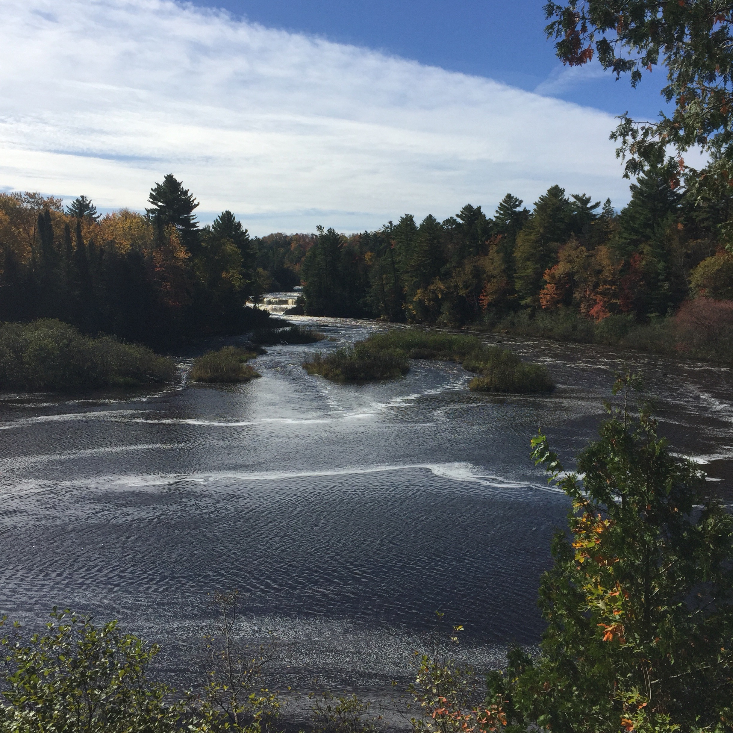
Tahquamenon Falls has two sections — Upper and Lower. The upper are the real story and are generally ranked the third largest falls east of the Mississippi behind Niagara and some other falls I’ve never heard of. Some 200 feet across, they are highly tannic due the course of the river through deep fir and cedar forests, making the river red in color. It’s a fairly busy exercise to stop at the park and take the hike to the falls. Everyone wants to see the third largest falls east of the Mississippi. But it’s worth it. You get a decent mile or so hike out and back and a good cardio test if you take the nine flights of stairs to the viewing area at the “brink” of the falls. As with almost everything this trip, the time of year makes this experience. The fall colors and the power of the waterfall make for a great image. The Lower Falls are fine, but pretty much a let down after the Upper. They are a shorter, narrow series of cataracts splitting an island in the middle of the river. Below you can see one side of the Lower Falls, the Upper Falls from a distance, and the Upper Falls from the “brink.”


From the falls it was an easy shot up the Soo, where I had the good fortune to catch the James R. Barker passing through the locks. Before the locks were in place, the two lakes Huron and Superior were joined by the St. Mary’s River, but it dropped 21 feet in less than a mile over rapids. So portage was the only means of conveying cargo from one to the other. Sault Ste. Marie actually means “the rapids of St. Mary” if you speak English. The locks were opened in 1855 and cargo has been flowing ever since. Iron ore from Wisconsin went upbound to The Soo, downbound to Detroit and turned into Chryslers, Fords and Cadillacs in the motor city. The Soo really is what this edge up here has been all about. People and industry facing out — to the opportunity afforded by being on the edge, and finding ways to make a living of it. This is not an enforced border. It’s more like the Gulf of Mexico. People who landed in America were forced to start on the Atlantic Coast, and people who went west for fame and fortune were forced to stop at the Pacific. On the Gulf, and here on the Great Lakes, people are here by choice — to make something of what the edge provides. This is not to say folks on the east and west coasts don’t make something of what those edges provide, but they didn’t have a choice having arrived there. Here, they looked at the edge, came up with a plan, and said I will stay here and take advantage of this.
I’ve covered some amazing ground up here — particularly on the UP of MIchigan. Much of it is country I want to camp and explore in — as I’ve done on the edge out west. But in almost every case, I’ve passed through that good country in the morning or early afternoon, and while I’ve stopped, hiked, explored around for a few hours, I’ve always moved on along the edge. Many times I’ve felt like the knight in Monty Python’s “Holy Grail” who comes across a castle full of beautiful virgins all begging him to ravage them, at least once. But he has no time for such silliness and moves on in search of the Grail. Now, admittedly I haven’t come across a castle of beautiful virgins begging me to ravage them, and I’m not looking for the wine glass Jesus used at the Last Supper, I’m just taking a lap; but the point is I do have a goal with this trip. I am going to make it around the country as close to edge as I can. So, I am always biased towards progress in that regard. The bonus of course is that I have a list of spots I will come back to one day to camp and explore, but for now, I am moving. Tomorrow I will be downbound on the Huron, take the ferry to Drummond Island and wander around there, and spend the night on the lake. I hope.
I haven’t spent much time in this blog talking about the people I meet out here. I chat with the cashiers, wait staff and other locals everywhere, and their perspectives color my thoughts on the edge. But I also meet folks not from here who are just out here. In Wisconsin, for instance, somewhere between Hebster and Cornucopia, I stopped in one of the small community establishments that serves as fuel stop, butcher shop, grocery store, hardware emporium and candle making supply depot. The old gal running the place was in her mid-60s, still sporting long gray braids and hanging on to her tie-dye. She made her own Kombucha and was not shy about extolling its virtues. I didn’t have the stomach to try the fermented mash, but it seems to be treating her well. Anyway, when I went outside to pump my gas I ran into a couple with their ATV. They were in their 70s, fully be-cloaked in weather proof, insulated suits adorned with all manner of zippers and pockets. Their ATV was a Polaris four-wheeler that you ride astride — not one of the side-by-side versions. It was outfitted with a special seat that provided a backrest and armrests for the rider in back and a backrest for the rider in front. It had extra fuel tanks on the back, a cargo box between the handlebars and saddle bags. The lady was already in her seat when I walked up and the man was studying a map zipped in a pouch on the cargo bag between the handlebars. This is quite a rig I said. Do you all just ride the trails around here? Yes, he said, but this darn map is not always very good. Do you camp out when you’re out there I asked? Oh no, the wife said, we’re from Southern Illinois (as if Southern Illinois people don’t camp), we rent a place here and just spend the day on the trails. Because Wisconsin welcomes ATVS, Illinois doens’t want anything to do with us. Are you off on the two tracks mostly, I asked. The old man said well we try to be but golly these maps are so darn poor, we don’t always end up where we think we are going to be. But that’s okay. Tell me about it I said.
Then in the Copper Mountains, after riding the spine all the way out to the end and then venturing further on that dreadful logging road I rounded a corner about 7 miles in and there was a Volkswagen Vanagon camper on the side of the road. A lean guy, gray hair and beard, I’m guessing mid 60s, was leaning agains that side of it eating from a baggie of granola. I passed them and came to a huge logging operation about another mile down the road, turned around and went back. When I got to them the second time, he eased off the van and moved towards me so I stopped and rolled down the window. You missed the turn to High Rocks Bay didn’t you, he said. I guess so, I said. We did too, but the road there is so bad we stopped here for lunch and we are going to bike down. We chatted — he is a retired railroad guy and this is what he and his wife do. Travel around and see stuff. She was delightful, healthy, and wearing a snazzy pair of earrings she may have gotten from a local copper smith. I told them about my adventure, we discussed vehicles and they told me about places they’d seen on the UP (they are headed west, to my eastbound track) and I told them about the Porcupine Mountains and Superior National Forest. Eventually, I cranked up the truck and said I needed to be moving on. As I drove off he raised his hand and made circular motions and said hey man, keep on making the circle man. And that’s just what I intend to do.
