The Edge of Perfection

From high above Hancock, MI, the Keewenaw Waterway

I suspect it will come as a surprise to none of you that I didn’t end up today where I thought I might.  But more on that later. First order of business is to make a recommendation.  I don’t do “favorites” on the edge, because, honestly, I’ve found redeeming qualities in almost every aspect of it, and this isn’t about pleasing me, it’s about making a trip around the country on the edge or as close as I can get, and seeing what I see.  That said, I do occasionally suggest you put a place on your list.  Today, I would add Porcupine Mountains Wilderness to that list, and the entire Copper Mountain Range area from Hancock, MI to Copper Harbor, MI.  These places are the reason I didn’t end up where I thought I might — they were so spectacular that I spent all my time in them.

A series of pictures of the magnificent Porcupine Mountains WIlderness

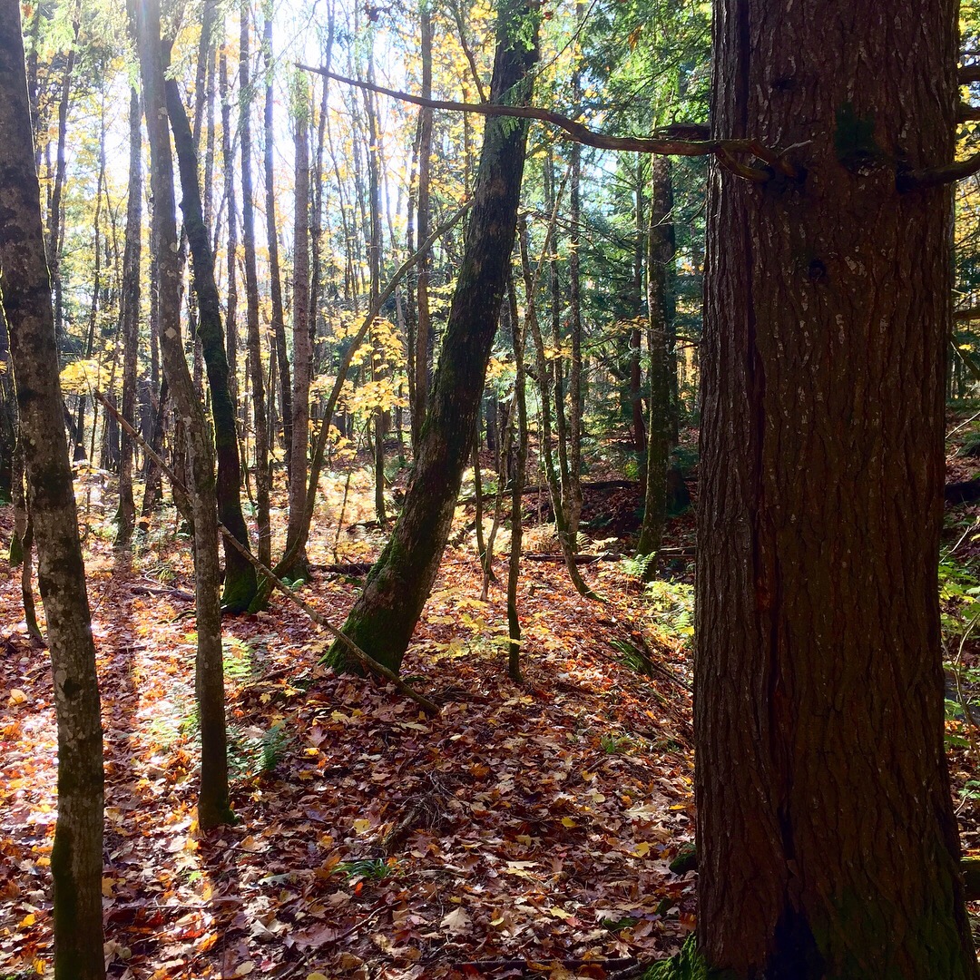
I left Wisconsin early because, you’ll recall, I had a plan to get to Grand Marais and I knew I was going to push it if I stuck to the edge. Almost as soon as I crossed into the UP of Michigan, I knew the plan was in jeopardy.  Everything got quieter in Michigan.  That’s a crazy thing to say, I know, but if you were with me, you’d know what I mean, and furthermore, that I’m right.  It did.  Also, variety appeared almost immediately among the forest species.  While the aspen and alder were still there, now there was oak and maple and larch and hickory and walnut and birch and basswood and hemlock. And the forest itself was healthier — gone was the tangle of underbrush and thicket, in was the open woodland with fern and moss.  And it got quieter.  By the time I got to the Porcupine Mountains Wilderness I was in love — once I got there I was like a middle aged woman on the front row of a Tom Jones concert, I was in lust.  Now, it is cheating to come here at this time of year. All those species of trees I mentioned earlier are painting a fall picture like the most amazing one you can imagine in your head right now — only better.  Inside the wilderness area you get all that, plus the structural issues of the forest I mentioned, plus the presence of mountains, plus the presences of beautiful little streams every few hundred yards.  My first plan was to just find a course through the wilderness that maximized my exposure to all this, but soon I had the truck parked and I was afoot, just wandering through the forest along stream beds, stopping to sit and listen, and basically being a goofy kid in love.  The whole of the wilderness is over 59,000 acres, but it has a continuous stand of hardwood spanning over 31,000 acres that makes it the largest old growth hardwood forest west of the Adirondacks.  I believe in all that.  And while the ranger will tell you ther are 87 miles of trails to hike, I will tell you it doesn’t matter.  You can just walk off any road or two track in the place and have a great time.  The forest is open and untangled. Your only obstacle may be one of the many streams, but I’d consider that a feature not a bug.  The Indians named the place because the mountains have the shape of a porcupine.  The basalt rock geology is full of copper, but none is mined here now.  This is a special place and one I will come back to once I’ve finished the edge.  To sit and to stay and to listen and to see.  

Where the Porcupine shaped mountains’ tail meets Lake Superior

When I finally crossed the the Porcupine Mountains, I was on the shore of Lake Superior again; which I followed dutifully north and east into the Copper Mountain Range out on the Keewenaw Peninsula to Copper Harbor and, as it turns out, beyond.  If you look on the map, you will see a funny little appendage sticking up out of the Upper Peninsula of Michigan — call it the really upper peninsula.  This is the Keewenaw — which is the Chippewa word for shortcut.  Seriously, the Chippewa figured out you could cut across the Upper Peninsula by water via a water route through lakes and rivers that divide the appendage between the now towns of Houghton and Hancock.  The Keewenaw is (was) rich in copper as a result of some crazy basalt spread out in the Pre-Cambrian period.  The key here is what you dig up, if you can do that, is pure copper.  Most copper is created from copper sulfides or oxides which are mined and refined.  The Keewenaw copper came out of the ground as copper.  Beginning in the mid 1800s companies began exploited the finds first made by the Chippewa, diggiing deep shaft mines because the copper tended to occur in vertical seams.  It was labor intensive.  Copper prices fell and the mines closed.  We went to war in WW1, copper prices rose and the mines re-opened.  We stopped being at war, prices stabilized and the industry consolidated.  This is a familiar story — I will cut to the chase.  By 1968, the mines were done.  Today you can get a tour underground if you are into that sort of thing, and the grand homes and Opera House of Calumet are there to look at, but there is no more copper coming out of the ground commercially.

This bothers me not in the slightest.  When you climb up onto othe mountain range at Hancock, the road turns east and north on the spine of the ridge and simply runs out to Lake Superior.  Falling away on both sides to the lake, the Copper Mountains are like an angry cat’s back — in this season a calico cat — coated with color and spiked with the rock that holds pure copper deep in its veins.  Like the Great Sequoias out west, there is no economic equation to get at the value of this resource — it is too expensive to get it out.  The benefit, of course, is an amazing piece of country that is essentially unmolested (the mines were vertical affairs and disturbed little) and stunningly beautiful. At the end of the highway, there is a little circle to turn you around and head you back off the Keewenaw the same way you came.  But there is also a dirt road heading further out to the tip of the peninsula.  I took that road.  I highly recommend it, if you have four wheel drive and a decent set of tires.  The road is atrocious, but not impassable for a stock vehicle.  And the ride, view and isolation are worth it.  You can drop down to see the Hurricane Harbor, or stay on it all the way to the High Rocks Harbor.  All of it represents more of this stunning landscape.

A dirty road to a pretty place int he Copper Mountain Range

So, I turned three hours worth of driving time into a full day of parking and wandering and going places I didn’t even know were on the map.  Whatever.  The edge here is magnificent.  Everyone who is here is looking out to the lake, for their fortune, to load their wares, or just to see the stunning Gitchee Gumee.  They want to be here.  They aren’t worried about inland, they are worried about the weather. I loved every minute of it.  For tomorrow, I’m going to start the truck at around 7:30 and head out.  No promises beyond that.

A Blue Collar Edge

Morning mist over the Stony River in Superior National Forest

Early morning was wet and cold, so as I let the car warm up and clear the windows, I dug out a detailed map of the Superior National Forest and found a route via a series of Forest Service roads that would minimize the amount of “backtrack” I had to make after getting out to Grand Portage.  I eventually popped out of the Forest at Grand Marais, had a handful of miles to Grand Portage, and then turned around to head south to Duluth.

A morning ride through any forest is great, but one through Superior National Forest, with a cottony fog hanging over every body water, the fall colors in the trees, and the promise of the big lake they call Gitchee Gumee at the end of it is very great.  For Forest Service roads, the ones in Superior are actually better than average. The hunting population was generally off the roads, and from the sounds of gunshots, was doing pretty good. I kept to the roads, and when I stopped for a picture, or took one of the two tracks, I kept an eye out.  The forest steadily gains altitude as it approaches the “rim” of the depression that would fill with water and become Lake Superior. The mixed hardwood is accented by rock outcroppings and the ever present water.  Lakes, ponds, rivers — all gin clear — work their way through the forest, to the rim and over the edge.  Between gunshots, the only sound is the hum of the tires and the wind doing its best to separate the last of the fall leaves from the trees.  It’s a good tonic and a good way to get your head on straight for the day.

While you have the sense of the big lake every time you get a view of the horizon, you don’t actually see it until you top out on the rim — and it fills the sky.  I can see how early explorers were sure it was the great sea they were expecting to link them to the orient, until they tasted it.  As a body of water, it is something: average depth is 482 feet, deepest point is 1,333 feet; there are 2,726 miles of shoreline; you can see up to 60 feet deep in the clear waters; and, it covers 31,829 miles of surface area. (And don’t worry, I will get to Gordon Lightfoot an the Edmund Fitzgerald when I get to Sault Ste. Marie)

Grand Portage Bay with Hat Point to the far left (Canada on the other side of that point) and Grand Portage Island just right of that. This is another corner on the edge.

Minnesota highway 61 is sort of like the midwestern version of the Pacific Coast Highway.  From Grand Portage to Duluth, it rolls 145 miles or so, all of it immediately along the shoreline of Lake Superior.  While it doesn’t have the gut tossing drama of the Pacific Coast Highway, it does have the same tenacity of purpose.  Most of the rock formation that edges the Great Lake is a sandstone formation left over from the warm sea that once spread from the Appalachians to the Rockies, but there are “pillars” of igneous rock that were forced up through the porous sandstone by volcanic pressure, and these “pillars” often reach out to the shoreline itself.  This creates picturesque, foaming waves, formed largely by the wind, crashing along the roadside and making it difficult to stay in your lane.  The road is smooth and basically straight for the entire run, interrupted only by speed limit changes for each little community.  And that’s really what settled my perspective on this section of the edge.

Up to this point, the edge has been a sparse place.  From Venice, Louisiana to Southern California, to the Straits of Juan de Fuca, and all the way across the 49th parallel, the edge — with a few posh exceptions on the west coast — has been a place of very few settlements, remotely clinging to a place nearer to something else other than the United States.  While there are areas of wilderness from Northwestern Minnesota to Northeastern Minnesota, all of it is accessible to major metro areas, and all of it is in a state where the culture is decidedly “outdoor-oriented.”  The result is that the edge up here is populated and busy.  But the entire length of of the western shore of Lake Superior has a kind of late-60s, early 70s vibe.  Everything is well kept and clean, but it is dated.  The resorts, the homes, the commercial buildings, all look like they were in their heyday in the 70s.  And almost none of them are ostentatious in any way.  Simple buildings, in a beautiful place, populated with simple, good people.  I have no evidence for this, but as I thought about it, this area was the home of industry that last had any real power in the 60s and 70s.  Timber, iron and steel, copper.  The move to get a place on the lake, or in the woods to get away from it all must have happened in a big way during the heyday of those industries.  And the people who made those moves — hard-working, blue collar people — remain that today.  Just older.  They may be retired, but they get up, take care of the house and yard.  Take care of the boat and cut the firewood.  They go to church (mostly mass from the look of it) on Sunday, have coffee at the cafe every morning, and don’t meddle.

A blue collar shoreline for a blue collar lake

The fact that this is the most accessible edge, east of the Mississippi, reaching down into the country more than just surrounding it, in the figurative midst of the bulk of the country’s early industrial heart, is making this trip around this section of the edge more of a road trip than an adventure.  But it is proving just as important.  I’ve had to reign in expectations, and enjoy what is in front of me, rather than make the journey fit some model.  And that is very much in keeping with the idea to start this exercise.

At Duluth, I turned east and north into Wisconsin and out onto the little knob of the state that juts into Lake Superior.  I have no sense that pride of state is any less in this area, and I’m certain the state itself values the area, but the area is a thing unto itself.  To begin with, it is basically empty.  At the very northeastern tip, adjacent to the Apostle Islands National Lakeshore, there is some significant activity.  The town of Bayfield is sublime — frozen in time and crisp as a newly laundered shirt, it is the model of shoreline towns.  The Indian reservation has, of course, a casino, which despite it’s isolation was busy.  But other than that, the entire section of the state along the lake is empty.  The vast forest lands are peaceful in their isolation, but unremarkable in topography and formation.  The rivers here are iron rich and prone to clay over wash when rains are heavy, so today, the southern shore of Lake Superior was frothing red from the shoreline to about 300 yards out.  I’ve made it almost to the Michigan border and will be interested to see tomorrow how tings change when I cross onto the upper penninsula of that state.

Chequathnegon Bay Lake Superior and the accompanying Lighthouse, Wisconsin

My plan — and I’ve been wrong about these plans so far — is to move across the top of the Michigan Upper Peninsula through the Porcupine Mountains Wilderness, the copper mining area and all the way to Grand Marais, where I hope to camp on the beach and find some agates for my wife.  But who knows.  I will find the roads, and I will stick to the edge, and I will see what I will see.  I like the working man flavor of the edge here.  I expect I will like Michigan as well.

To the Northern Edge

Lake Rainy, Voyageurs NP, about to earn its name

The plan today was to go from Grand Forks, ND, up to the Canadian border and across Northern Minnesota on the edge to Voyageurs National Park.  On paper, that seemed like a pretty good haul.  In reality, it was over in a couple of hours.  I’ve been wrong about time to travel most of this trip — adjusting from the way out west distances to these has baffled me.  But, this is a wandering program, and by definition, the rule is adapt and revise.  So I ended up about an hour and half away from Lake Superior.  But I’m getting ahead of myself.

Northern Minnesota is a paradise for wildlife.  I’ve been traveling along the edge for a while now, and I’ve never run into the variety and quantity of wildlife that I saw today.  That said, the bulk of the terrain is pretty boring.  Aspen and Alder, wire grass, aspen and alder.  Out of Grand Forks, I came across my first wildlife pretty quickly after I crossed into Minnesota — and it was a doozy.  About 30 yards off the highway, galumphing through the edge of an open field was a dang moose.  Great, waddle dangling hulk of a moose.  I’ve never seen a moose live in the wild and they are just hulking things.  This was a small bull, not yet in possession of the chandelier rack that he may soon have, but he was still huge.  Woke me up and got me focused for a day that would include more deer than I counted, grouse, chukkar, eagles, hawks, multiple types of vulture, raccoons, possums and a handful of big hares.  This activity was especially welcome because from Badger, MN all the way to Voyageurs NP, the terrain is the same.  It’s wild, unmolested by industry and pure wilderness.  But it is all the same.  Alders, Aspen and wire grass with little change in terrain.  After the glorious middle of the state, I was disappointed with the North Country, but it was peaceful.  

They are so not into me

As for the edge, it’s as though there isn’t one.  For the bulk of the trip across the northern edge, the Rainy River marks the border.  Everywhere there is room, homes dot the shore on the US side.  Folks wake up and look out the kitchen window over coffee at Canada, not more than 100 yards away.  They go get the paper and look out at America — and it goes on for a three day drive to the south at least.  But there is not any sense of difference.  The Canada ground looks the same, there is no particular sense of a border or control.  If you wanted to go to Canada and you rowed your boat, you could be there in 5 or 10 minutes and I don’t think anyone would know the difference.  I never saw a border control or customs official of any sort.

There is no wall, fence or even a sign about the border.  I suspect this is a function of desire more than geography.  There is no trade bridge or “International” bridge or anything.  People in Canada are happy and busy, people in America are happy and busy.  It’s not until International Falls, MN that you get any connection and it’s just sort of a left turn to Canada, over the bridge.  I suspect during the dark ages of Prohibition there may have been some traffic across the Rainy, but all anyone there is doing now is catching Walleye.

Voyageurs National Park is a bit unique in that the entire park is basically on water.  To really see the park, you need to get in a boat with some supplies and camp around the various islands.  I didn’t have a boat, so I hiked around a bit and looked at the canoe paths and lakes from the shore.  I’d like to go back with a boat.  Voyageurs is named for the French Canadian traders who moved trade goods from Montreal to the the area and carried fur back.  There’s would be a role that started wars (French and Indian) and stressed diplomats as the French, English and new Americans tried to sort out the border.  Chiefly, they found a way from Montreal to the western edge of Rainy Lake, and managed the various competing Indians along the way.  This route would ultimately become the US/Canadian border.  They paddled big freighter type canoes, and played the middle politically.  Practically the entire North Country of Minnnesota reveres them.

From Bemidji north, for the entire middle of the state there is basically nothing.  So it’s no surprise that once you get up top, they sort of treat themselves as a separate thing.  Everything is noted as “North Country” this or that.  Insurance companies advertise insurance for “the North Country” as though it is a different thing.  The people are uniformly nice.  The cafes are full at all hours, first with farmers, then with locals for late coffee, then with lunch, then with retirees who take over the places to play cards.  Every town has multiple bars and liquor stores, but the people drink strange things like sweet manhattans with olives.  The other thing is that while it seems to be the middle of no where, there is almost constant civilization along the edge, though sparse.  I didn’t find real wilderness until I went south from Voyageurs and found the Ely/Buyk Echo Trail across the Boundary Waters Canoe Area.

Superior National Forest

I had expected to be in the Superior National Forest (Boundary Waters) area tomorrow, but after getting to Voyageurs before lunch, I headed there today.  Mercifully, the terrain changes a good deal as you move east — large granite formations appear and the forest goes from tiresome Aspen and Alder to larger conifer (though the Aspen remain).  You also get more and more water — which helps create lovely vistas.  Lakes and streams left from the glacial retreat hold beaver and waterfowl and give the ever present gray sky something to reflect, however dully, off.  I loved Superior National Forest and would like to have stayed there.  But today is opening day of something — juvenile deer season or moose season or something — and every two track I travelled ended with a couple of trucks.  I’m happy about this.  People getting out and around is a good thing.  But when you are 20 miles from anything and you travel two miles down an unmarked road toward an un-named lake and find at the end a couple of trucks, and this happens over and over, you start to feel surrounded.  So I kept pushing east, venturing off the dirt road on the two-tracks regularly, and ultimately, I ran out of forest and ended up in the community of Ely, MN.  Which is lovely.

Bonus Superior National Forest

Tomorrow I will travel an hour and a half north to Grand Portage, then retrace my steps south along the shore of Lake Superior to Duluth or thereabouts.  I can’t predict anything on this trip when it comes to where I will be when.  I’m looking forward to the Great Gitchee Gumee and the change in scenery and, as always, I love being on the edge.  I”m forever learning to be in the present and worry less about the what and where.  The edge continues to make me better.

The Source of it all

One of the hundreds of lakes in the Itasca watershed that contribute to the source of the Mississippi River

Having grown up in West Tennessee and crossed the Mississippi River at Memphis a million times going back and forth to my family’s home place, or the duck lease; and then having watched the musicals, read the novels and studied the history of the river, it was impossible for my mind to get around the burbling brook at my feet.  But there it was, the Mississippi River, narrow enough to jump across, slipping over the bank of Lake Itasca and heading east and south to start catching water and dreams and dollars and lives.  I started the morning in Red Wing and followed the river until it crossed under me around Hastings where it turned west after catching the water from the St. Croix. Now on the northern(eastern) bank of the river, I skirted north of the twin cities, caught up with it on the northwest side, and followed it straight up the middle of Minnesota past St. Cloud, Little Falls and Brainerd. At around Grand Rapids, the river starts jumping from lake to lake (one reason its source was so long a subject of debate) around and through the Chippewa National Forest before finally coming to the source at the northern end of Lake Itasca, south of Bemidji, MN.

The Mighty Mississippi as it tumbles out of Lake Itasca

Seeing the little brook at my feet brought home the point Paul Schneider makes in his excellent book “Old Man River”, the Mississippi is not one river, it is many rivers.  There’s just enough water in the Lake Itasca watershed to get the Mississippi to Hastings where it gets its first real push from the St Croix.  And from there it is off to the races — the Chippewa, the Des Moines, the Wisconsin, the Illinois, the Ohio, the Missouri, the Arkansas, the Red — I’m just cherry picking here, but you get the picture.  Basically, the little brook called the Mississippi just happened to be the northernmost brook to slip into the ditch left when the ice sheet receded and the melting ice and lakes of the north blew down the depression between the Appalachians and the Rockies.  I feel like it should be one of those “boost your confidence” tours to have people start at the little brook by Lake Itasca, then blindfold them and fly them to the tug docks at Memphis or New Orleans, turn them loose and say don’t let anyone tell you what you’re capable of — these are the same bodies of water.”  Of course, it’s really just gravity and geology, but, hey, never let facts spoil a good sermon.

Choosing to follow the river to get to the spot I last left the edge was a good choice for me.  It took longer, and was harder to plan for — I was wrong about most of the layover spots — but I saw genuinely new country (central Minnesota), and I fell under the spell of the river. It actually got physically harder to keep pushing upstream as the roads were less convenient and I had to go east to get west, or south to get north, because of all the lakes and bogs; but I will never forget kneeling by that little brook and thinking about that big river washing under the bridge at Memphis.

There are many lakes in the Itasca watershed that makes up the source of the Mississippi, and while the river actually flows from Itasca, the other lakes in the watershed are beautiful. This is Elk Lake, catching a particularly bright ray of sun

Oddly, once you get west of Itasca, the state is very different.  While the trip up the middle was a glorious montage of rolling hills, rocks, bogs, birch forests and purple-blue lakes, the western state turns quickly to stony prairie with little to no interest at all.  My guess is the ice sheet, and the way it receded has something to do with it.  Itasca basically ended up on the northwest corner of the ditch.  Once past it, you’re on the flat ground.

I made it to Grand Forks, ND, which is where I last left the edge.  Tomorrow I will head north to the border where I will turn east along the top of Minnesota, through International Falls and out to Voyageurs National Park.  What happens after that is unknown. The vast area of the Boundary Waters and Superior National Forest offer very little in the way of east-west routes unless you are in a boat you can portage on your shoulders.  But I’ve found a couple of tracks that will allow me to stay pretty close to the edge as I work my way over to Ely and further east to Grand Portage.  From there, it’s a matter of following the shores of the Great Lakes Superior, Huron and Erie.  One thing I’ve learned venturing around the edge is that certainty is a rare commodity, so I only plan for tomorrow.  And tomorrow, we get to the edge and follow it to Voyageurs.

River Drive

A dark, wet dawn on the banks of the Mississippi

I started the day where the Des Moines River empties into the Mississippi from the west and I ended the day (basically) where the Chippewa River does the same thing from the east.  Along the way I do not know how many other rivers first from one side then the other fed the great river.  And this is the story of the Mississippi River — it is not one river, it is the sum of all the rivers in the drainage.  The Des Moines or the Chippewa may not mean much to you, but think about the Ohio, the Missouri, the Arkansas — these are rivers with entire histories across the east and west of our country and they disappear into the Mississippi.  From Keokuk north to Red Wing Minnesota I rarely ventured far from the banks of the Mississippi.  To the east, all day, were Illinois and Wisconsin and periodically, civilization got thicker around a bridge making a way across.  My bartender in Keokuk, where there is a bridge to Hamilton, Ill., said when I asked if she was from Keokuk, “Oh no, I’m a Hamilton girl.”  She’s worked at the same family owned, local Keokuk Iowa restaurant for almost 30 years (I ate at this place in 1988 when it was in the basement of the Iowan Hotel and she said she was volunteering as a busser then).  She knows customers by name, calls their orders out to them before they open their mouths, looks, talks and acts like an Iowan.  But she’s a “Hamilton girl.”  If ever you needed an indication of the strength of the Mississippi River, there you have it.

It would be hard to imagine a better way to go north or south in the middle of the country than the Great River Road.  I’ve been primarily on the western side, so I can’t speak for Illinois and Wisconsin, but Iowa and Minnesota are sublime.  To me,for a good drive, there is kind of a magic mix among scenery, points of interest/towns, and open road.  For the most part, the Great River Road ticks all the boxes very well.  I spent 1987/88 traveling all 99 counties of Iowa, but I’d forgotten the northeast corner, which, for my money, is perfect.  Hardwood forest, rolling hills and high bluffs, open ground, interesting towns along the way.  I do wish the weather were better today.  From dawn until 4:32 pm I never saw the sun.  Most of the day it was raining.  Until about 11:30, the fog was so thick I had no idea if I was next to the river or in it. I did catch a break around 11:30 when I got to the Effigy Mounds National Monument, just north of Marquette, Iowa and the rain stopped for period.

A bear effigy mound high over the river

Located just inside the far western edge of the region generally associated with effigy mound culture, the national monument includes a north and south unit, miles and miles of hiking trails, and 206 known prehistoric mounds, 31 of which are animal effigy mounds.  Historically, we know humans have been in this part of northeast Iowa for over 10,000 years; 2,500 years ago conical mounds appeared and were chiefly burial mounds; around 1,700 years ago, linear mounds appeared, but there was no evidence they were burial mounds, and some were connected to conical mounds forming what are known as compound mounds; the real art started about 1,400 years ago in the Late Woodland Period when the people in the Upper Mississippi began building animal effigy mounds.  Most are bears, or birds.  They are typically 2-4 feet high, 40 feet wide, and 80 feet long.  But sizes, as they say, vary.  What’s interesting to me, is that there is no ceremonial or ritualistic reason for them.  There is indication in some that fires were set in the region of the animal’s heart or head, but no conclusive evidence that these mounds are anything other than what I would call yard art. Culturally, there is a link between the bear and the earth and the bird and the sky, so if you were an earth family, you probably built a bear mound mound and a sky family, a bird mound.  To be honest, today, you can’t tell one from the other, or either from a small hill; but, back in the day, if you were looking at them from above, they were clearly birds and bears.  Now how people 1,400 years ago got an aerial view of their handiwork, I don’t know, and, since from the ground level even then they didn’t really look like much, the mystery deepens.  Nevertheless, when you climb the 2 mile trail to the top of the high bluffs over the river, through hardwood forests of Hickory, Oak, Cherry, Maple and Cottonwood and find, on the spine of the ridge amidst oddly clear green spaces, dirt bears, your skin kind of prickles.  It’s a spiritual place for sure.  Then, after 650 years or so, they stopped.  No more effigy mounds.  I suppose tastes changed, or the Joneses down the way made a pyramid mound and then everyone just had to have one or some such thing.

A lock and dam on the river (no it’s not curved the panorama just makes it look like that)

North of the Effigy Mound National Monument you are hard into the Upper Mississippi River, which is different primarily by constraint.  On both shores, high bluffs hem the the old man in and efforts at man-made constraint — in the form of locks and dams — create pools and “lakes” that make it difficult to tell what is river and what is just lots of water. Above some of the dam and lock complexes, the Corps of Engineers has used the material dredged up from the channel to create man-made islands which they seed with native grasses.  The result of this is that in the pool areas above the dam, a waterfowl paradise is born. The islands provide nesting and shelter area, and the slack water of the pool is excellent for feeding.  Swans, geese, ducks and all manner of fowl have, thanks to the corps, their Eden.  The effect of all of it — bluffs on each shore, the river banging first one side and then the other, the islands and pools and braided lakes on the slow side of the river — is really remarkable scenery.  

Man made islands in pool #8 above the dam

Tomorrow the river turns west towards its source in northwestern Minnesota and I will as well. After a visit to the headwaters of the great river, I will finish the day, late I expect, where I last left the edge — in Grand Forks, North Dakota.  From there the Fall installation of Edge Trek 2017 will really begin.  North and east to the Canadian border with Minnesota, through the boundary waters region and on to Lake Superior.  I don’t know how far I will get on Saturday, or care really. As I’ve learned already, the adventure is in the going, and I’m just getting started.

Day One

In 1937 a little old lady put a wooden cross atop the Wickliffe Mounds on the banks of the Ohio. Across the ensuing 75 years that simple cross would move to the confluence of the Ohio and the Mississippi and grow to 90 feet. Just because.

The earth has been “making” the Mississippi River for several billion years.  Something called the North American Craton has been sliding and crashing about since New Jersey and Marrakesh were connected and, among other things, it eventually caused the Appalachian and later the Rocky Mountains to be separated only by a vast inland sea.  Through the various ice ages when sheets of ice a mile thick spread as far south as today’s Chicago, the water had no where to go as the earth between the ranges lifted, except down the Mississippi.  When the waters of the Arctic and the vast lakes of Canada finally broke through the ice, they cut a gorge through the upper Mississippi that would define countless civilizations, start and end wars, and ultimately become the busiest waterway on the planet.  Portions of the Mississippi River are older than the Atlantic Ocean.  Any water south of the Great Lakes, west of the Appalachians and east of the Rockies, finds its way to the Mississippi and from thence to the Gulf of Mexico.  41 percent of the continental US drains via the Mississippi.  There are bones and teeth of Mastadons, Mammoths, Giant Sloths, sharks, rays and all manner of prehistoric flora and fauna buried in its mud.  I can’t possibly detail all that is the Mississippi, but fortunately, someone has.  And he’s done it in prose as lyrical as the sounds of the river itself.  Regardless of whatever else you may chose to do, I suggest you get a copy of “Old Man River” by Paul Schneider and read it.  I’ve stolen liberally from it and will read it over again once this trip is through.  It is a masterwork of history, archeology, culture and language.  It is the story of the Big Muddy, The Old Man, The Mississippi.

Today was really the first day of the adventure.  I followed the Mississippi from Dyersburg, TN to Keokuk, IA via the Old River Road.  I got lost.  I found a new way.  I strained to see the river through the trees and I walked the banks at the confluence of it and the Ohio — which deposits more water into the Mississippi than any other two tributaries combined.  I saw industry and agriculture, failure and plenty, and I saw some of the cultural history of some the oldest civilizations our continent knows.

I will know more of the mound builders tomorrow when I get to Northeast Iowa, but as a preview, prehistoric yard art was a big deal.  For no reason other than art — that anyone can figure out.  My son will be glad to hear that.  But that’s tomorrow.  Today was a day of wandering, not unlike the river itself, through hardwood bottoms and bluffs, a day to see the power of rich alluvial soils.  To realize that the same river that can and has killed tens of thousands with its floods, can feed hundreds of millions with its plenty.  My history is so short — the river is in songs from musicals and novels by Twain — but to see it on the ground is to recognize its permanence far beyond any refrain.  It is literally absorbing the effluent from millions of years of geologic change and rinsing it all to the sea.  As an analog for work, or sins, or impermanence it works well, but as a geologic constant it excels.

Tomorrow I hope to see the effigy mounds of the early Mississippian cultures and get better acquainted with the Upper Mississippi from Northern Iowa into Minnesota.  Eventually, I will reach the northern edge where I left off, but for now, I have my hands full of the Big Muddy.  Sometimes, when you are headed to the edge, you cross a few lines.  I’m going to keep going and I will get there when I get there.

Leaving

Today is the day of leaving.  It’s an odd thing to leave home without a real idea of how long you will be gone or exactly, precisely, where you will be while you are gone. I notice this each trip, but I don’t think I ever really spent much time on it before.  Most of the time any of us goes anywhere, we have an exact idea — flight times, hotel reservations, outings, dinners, the works.  When I leave, I know which direction I am going and I know the place I last stopped and I know when I have to be back home.  That’s it.  I believe it makes me more reflective on this first day.  Whereas the night before, heck the weeks before, I’m all excited and thinking about the trip, on the day of leaving I tend to spend most of the day thinking about home. About how lucky I”be been to be able to go off on a wild hair like this.  About how hard I worked to get that lucky.  About how ridiculous it is to have a wife who loves me so much she is excited for me to go off on a wild hair like this.  It’s completely nuts.  But it also completely glorious. I don’t know how much time I have here and neither does anyone, but we can all make the most of what we have while we can.  So, let’s go.  Let’s leave.

I’ve talked before about the getting to and the going from.  I have to get back to where I last left the edge before I can go from there around the edge some more.  I hate boring drives, so I try to make the getting to as interesting, or at least marginally so, as the going from.  For this leg, I need to get to Grand Forks, ND and go from there around the northern edge of Minnesota, the Upper Penninsula of Michigan, down the eastern edge of the “thumb” of Michigan and around the southern shore of Lake Erie to Niagara Falls. So, how to get from home to Grand Forks in some manner that holds one’s attention?  My choice was the trail of tears to basically the Mississippi River, and then up the Mississippi via the Old River Road to its source near Bemdji, MN, and across the border to Grand Forks.  Today was the Trail of Tears.

There isn’t one Trail of Tears.  There are several.  They represent the pathways some 16,000 or so American Indians — Cherokee, Creek, Choctaw, Seminole and Chickasaw — travelled from the southeastern United States to Oklahoma.  Oddly enough, my Great Grandfather would one day open a general Store in Oklahoma that served the coal miners and what was left of the Cherokee Indians who were trapped there.  My Grandmother told stories about serving those people in the store and of their quiet dignity as they found ways to trade for their needs and somehow survive in a manner they’d never been taught among people they did not know.  ONe a story of generations on the rise, the other, a story of the inevitably downward spiral of a people who were wards of the state.  The tribes on the trail of tears didn’t go because they wanted to.  They went at the less than cordial insistence of Andrew Jackson, primarily because there was gold in North Georgia and the Indians were in the way.  As many as 5,000 Indians died on the way.  I followed what was known as the Drane Route and the Deas-Whitley Route from. Fort Payne, Al to Tuscumbia Landing on the Alabama/Mississippi border.  Today, that’s basically US Route 72.  I’m sure the landscape was dramatically different back in the day, but there is no escaping the change from the rolling tail of the Appalachian Range to the flat lands of the Delta.  A subsistence people must have wondered as they walked — in  addition to to where in the world they were going — how they would apply their skills in their new land.  How would they hunt, gather and commune in a country so different than their homeland.  How they would establish the same pride and leadership without their freedom.  How they would mourn those who died along the way, strangers in a strange land.  Today it’s just a road from one place to another, but for them it was a death march to an unknown place and an unknown future.  For me it is the beginning of a journey, for them it was the end of everything.  

I enjoyed the drive — despite the awareness of its history.  The soybeeans are yellow in the fall sunlight and, further west and north, the cotton fields reflected bright white in the setting sun.  Traffic was light and the road was smooth and good.  I was glad to be aware of those who had come before and glad to be able to appreciate their struggle in the context of their own time and in the context of the terrible choices made on behalf of a growing nation.  I didn’t have to agree with those choices now anymore that I had to participate in them when they were made.  But I did need to know about them.  To reflect on them.  To wonder how to manage change in a confusing time.  And it helped to take it all in.

It’s possible that one way I ease the leaving is to make my first stop at the home in which I grew up.  I did this last Spring, and I did it again today.  I ended the day of leaving at my childhood home.  Familiar, comfortable, and imminently safe.  A good spot to leave my real home and proceed to the unknown.  There will be challenges, choices, learnings and failings over the next weeks, but I will, like many before me, head off without expectations, hoping to find things of value.  Tomorrow I will strike the Great Mississippi River and turn north to follow in the wake of Zebulon Pike in search of the source.  I will use the Great River Road on both the east and west banks of the River as I head north, to the source and, ultimately to the edge, again.  I have now left, and I’m ready to begin.

Returning to the edge

A journey is in order. An opportunity to strip away the noise and commotion of real and imagined problems, actual and created grievances, and return to the simple realities of a life on the road. You will recall that last we were together on the edge, was at Grand Forks, ND, a short distance form the Canadian border and essentially the easternmost end of the flat, straight 49th parallel agreed to as a delineation between there and here back in the Treaty of 1818 which, in typical bureaucratic pace, settled matters resulting from the War of 1812 which actually ended in 1815. I won’t officially leave the 49th until International Falls, MN, but essentially, the days of straight drives are over.
Getting to the starting point is always a source of some internal debate — hurry along to get started, or, find a way to make the journey to as interesting as the journey from. For this leg, I will choose the latter and get to Grand Forks by ascending the Mississippi River via the Old River Road from somewhere near Dyersburg, TN all the way to the source of the River at Bemidji, MN and from there northwest across the ND border to Grand Forks. Hopefully the bulk of this ride will be on the western side of the River, but at the very least, it will adhere to the River itself whichever bank. I haven’t really seen the Mississippi River on my trek around the edge since it was floating barge traffic above my head on the way to Venice, LA at the start of this entire ridiculous adventure. I look forward to returning for an extended visit along the shores of this redemptive ribbon of drainage.

From Grand Forks, I will head east along the northern edge through International Falls, Voyageurs NP and the Boundary Waters of Minnesota before running slap into Lake Superior — the big lake they call Gitche Gumee. I will follow its western and southern shoreline through a patch of Wisconsin and out onto the Upper Peninsula of Michigan, cross between Lakes Michigan and Huron to follow the eastern shore of the “thumb” of Michigan all the way to Detroit, and then make a decision. I’ll either follow along the southern shore of Lake Erie to Buffalo, NY before turning for home, or, I’ll head back from Detroit and pick up there in the spring.
In addition to marking another segment of the edge off the list, I’ll get a chance to visit childhood noises like International Falls — which was always the spot the weatherman said was the coldest (weird memory fragment that) — and personally investigate the area that claimed the Edmund Fitzgerald, in the hopes of vanquishing that ever-present Gordon Lightfoot ear worm. Hey, it’s the little things. As always, I hope if you are so inclined you will check in each night to see what drivel I’ve spilled on the page and maybe offer a few comments. I’ll spend the next few weeks preparing the truck and organizing things, but should be on the road within the next 30 days or so.  Go to http://www.ropeandchain.com and you can register your email to get a notification whenever the posts go up.  Click on Edge Trek at the top left to see the so called rationale for this whole journey and review previous posts.
I’m ready to get out there.

7,929

After nearly 8,000 miles of travel over 7 mountain ranges, four time zones, and 20 states, I am through with my latest trip to and around the edge.  Since beginning, I have been from Venice, Louisiana on the Gulf Coast, to the Straits of Juan de Fuca at the northwest corner, to Grand Forks, North Dakota, just south of the border from Winnipeg Canada — the long way around, as they say.  It has taken three trips from Atlanta to cover this much of the edge.  My most recent was the most ambitious, and covered the most mileage, included the most diverse terrain, and took the longest time.

This is the part where one wonders what the heck one is doing.  I’m exhausted and a bit overwhelmed by the nature of being on the road, living out of the truck, for almost a month.  I’m also a little off kilter from having essentially been alone, processing all this experience, for so long.  So it helped to have a little over a thousand miles from Grand Forks to Atlanta, blitzing down the interstates, to try and get a rational assessment of the edge trek, where I am on it, and what it means to me.

I’ve covered the natural aspects of the trek — the exceptional beauty, diversity and just sheer wow factor of how much there is to see — in the daily posts.  And, I’ve tried to cover the cultural aspects of what is like to live on the edge in the various regions, and how different it is as you work your way around.  What I don’t think I’ve done particularly well, is step back and take a more general look at what this trip is doing towards the original impetus for it: assessing the relationship of the edge to some definition of America.

The first thing is that there is a big difference between the natural edges (Gulf of Mexico and Pacific Ocean) and the political ones (Mexican-American and Canadian-American).  I know this sounds like the most obvious thing in the world, but it feels very important when you are on the ground riding along.  The natural edges are places where people look over the side and think about what they can do to survive, profit, or otherwise benefit from their relationship to the edge.  On the political edges, there is historical evidence that the same was once the case, but today there is more a sense of tension there.  Even on the Canadian border.  The result is that there is a stronger sense of difference, this is America, that is not; which makes the edge more defining.  It seems like more a feature of America where it is a natural edge, not a defining characteristic.  If that makes any sense at all.
The second thing is that I am absolutely convinced, totally, that those of us in major urban centers, replete with communications and accessible comforts, are completely and utterly full of ourselves.  The amount of time we spend gnashing our teeth over the state of things (or wandering around the country and writing blogs about it!) is very, very different than that of the folks living on the edges.  For the most part (there are some large urban centers on the edge). Everywhere I have been, people are busy.  I only ran into one instance of ranting about politics and that was on the northern border in a bar, and the offending patron was in distinct violation of the bar’s rules for drinking in the bar. Now, I’m not naive, I realize there is plenty of bitching and moaning going on out here, but here is the thing: it doesn’t define them and consume them.  The edge means putting important stuff first — like dealing with the weather, or the local economy, or the broken truck, or your neighbor 20 miles away who needs a helping hand.  Whatever.  The land and people and work immediately around you on the edge is what occupies your attention first, second and maybe even third; before you get to anything else at all. I saw this same sort of ethos crossing the country to get to the edge and to return from it.

I tried to think about the different reactions I see at home and in the major urban centers with the ones I see out on the edge, and in the rural crossings back and forth.  I think it boils down to folks who know that a great deal of what they have to deal with can not be fixed by anyone or anything.  It’s too hot, or too cold, or too wet, or too dry, or too stormy. The storms blew something down, or washed something away. The mineral vein ran out, or the oil dried up. The fire burned through the forest and burned up the hay field.  The power is out.  The well is dry.  The satellite is out.  You can blame someone or something and be angry about this stuff, sure; but out here on the edge it also has to be dealt with.  So they deal with it.  Sometimes they need help dealing with it, and their neighbors help.   In the end, I think this self-determinative, independent, pioneering, if you will, attitude is very much in keeping with what defines America.  This is not to say everyone out on the edge is conservative, Christian, and wants to return to the good old days.  They embrace technology, many are pining not for the olden times so much as Woodstock, and I saw more legal marijuana and assorted chill communities than I ever thought I would.  It’s a diverse group out on the edge — but uniformly and fiercely independent. And, honestly, very nice.  I suspect folks may be putting on their best when they talk to me — they seem interested in what I am doing — but everyone is nice.  Seems like at least once around this trek I’d run into someone having a real bad day, but I haven’t yet.

The remainder of the edge trek with be on natural borders, save for a small section of Northern New York, northern Vermont, and all of western and northern Maine.  But, it will be a lot closer to people and urban centers.  It will be interesting to see if this makes any difference. I will return the edge, probably in the fall, at the northern Minnesota/North Dakota border and head east around the Great Lakes.  The geography seems a lot closer, but the edge is probably longer — if you could straighten it out — for the rest of the way around.  I’m hoping three more trips will have me back in Venice, Louisiana where it all started.  I look forward to all of them.

Post-Script

I can’t miss a chance to talk about my partner in all this wandering around — a 2002 Toyota Landcruiser.  It is a remarkable vehicle without which I couldn’t be doing this.  The confidence it gives me to be out here, alone, is a testament to its legendary reliability.  The attention to regular maintenance, and the additions I’ve made to it, allow me to know that I can go anywhere, in any conditions, get set up and comfortable, and get back.  It is equally happy crashing along the old Mojave Road or down the interstate. I won’t make any changes to the truck for future trips.

I may adjust gear a little.  I’m not happy with my camp table, or my stove.  And, I think it’s time to figure out a fridge/freezer solution that will expand my culinary options.  Storing food in a cooler is a hassle that turns into a mess, that turns into a bad day.  Coolers are for beer. And backpacker freeze-dried meals, as good as mine are – get boring after a week or so.

Finally, I had a friend join for a few days of this trek and it was awesome. He flew out to a an airport along the route, I picked him up and he just road along for a few days.  I hope more will do so in the future. It’s one thing to have me blather on about this, and another entirely to see for yourself.

If you’ve been reading along since the beginning, thanks for the indulgence. And feel free to share your comments here, or via email, at matthew.s.lewis@me.com. I’d be surprised if I haven’t said something in these blogs that was upsetting to someone and I hope if that was the case, he or she stopped reading.

Till I head out next, have a great life and go out and find your edge.

The Edge of Boomtown

Buffalo Country, North Central Montana

I have been traveling around a bit for a while, and I’ve seen some things.  But I haven’t yet seen ice fog.  Until this morning in Havre, MT.  So, for the uninitiated, among whom I counted myself until today, ice fog occurs when the thing that causes fog (which is related to dew point and something else I can’t remember) happens at the same time the temperature is below freezing.  I don’t know how common this is.  The net effect is that you wake up to a dense, milky fog which is freezing on everything it touches.  Which is everything. In the words of Todd Snider, “It’s odd.  I think.”  Anyway, it melts right off the car as soon as it is warmed up and I head east with the new Rigid Industries lights making daylight out of murk.  I can see the road, but nothing else, so I don’t have a lot to report on the early going.  This lack of distraction gives me time to remember the night prior when I got my first sense of tension on this northern edge.

Ice Fog

By and large the northern edge has been a naturally spectacular place, with all manner of flora and fauna and topography impressing at every turn.  But the relative scarcity of people has meant there hasn’t been much sense of what it is like actually being on this edge.  Unlike the shared southern border, this one has basically been a cultural non-event.  Until I started drinking at the local pub.  My barkeep was an affable fellow wearing a Kangol flat cap and madly pouring beers along the bar.  He had to do a little extra work for my glass of whiskey, which is apparently not a local choice.  This gave us a moment to chat, during which I remarked on how crowded the place was for a Monday night with no football.  He said it’s the Canadians, they all come here.  Because we’re Canadian-friendly.  And there a bunch of Canadians who are down here for work during the week.  I asked him if the other local spots were not Canadian-friendly.  He said not really.  I waited an appropriate amount of time for him to serve the other folks at the bar and during a lull re-entered the issue at hand.  What’s the deal with Canadians and the other spots I said.  Oh, everyone’s a good guy, he said, and they’ll help anyone out who is in a pinch, but they just sort of prefer to hang out with the local people.  Why is that I asked.  No real reason, I mean if you went in to one of the other joints, they’d be nice and serve you, but they wouldn’t go out of their way to talk to you like I am, so it’s not a Canadian thing, it’s a local thing. It’s just people around here have something in common and they like to hang out with folks they know, who are local, who do stuff and think about stuff like they do.  Like Brooklyn, I said.  He didn’t get it. 

The barkeep liked my accent, and I liked his two rules for drinking at the bar: No discussion of politics or religion. As I thought about it in the ice fog of US 2 whirling through north central Montana, it made some sense to the general order of things these days.  The people up here on the northern edge are uniformly nice.  But given the choice, which they are when it comes to where they drink, they drink local.  No real judgement about anyone not from here, just a preference for their own people who have shared similar experience and dealt with it in a similar way.  One could call this unenlightened, but then one would have to explain the out of the way trips to purchase eggs and beer and vegetables only grown locally, which seems to be the rage amongst the hipper set.  I think it’s kind of, well, normal; and doesn’t speak to any larger issue of our general polity at all.  While I enjoy the irregular oddity of drinking in a strange place, given the choice, I will drink with those I know.  This doesn’t speak to any proclivity for one type of person or another, it speaks to comfort.

Philosophizing accomplished I wait patiently at 70 mph for the sun to win the battle over the fog so I can see the country. Which it does around 11 o’clock.  What I see is buffalo country.  These wide open grasslands of central and eastern Montana were once the home of millions of buffalo.  The Indians followed the herds, rounding them up on foot or driving them off cliffs before horses, and used all the meat and all the hides to see them through the tough times.  Once they could steal horses, the Indians hunted them for sport and to demonstrate bravery, but always with some sense of conservation. White mean settling the west showed no such deference and simply killed them all.  So now the buffalo country is cattle country, fenced and divided and still providing the lush graze that feeds us our porterhouse Pittsburgh Medium Rare at the steakhouse.  

The source of the ice fog, I think, was the Milk River.  The northernmost contributors to the Missouri River drainage — as Lewis and Clark discovered, not northern enough — it makes its appearance around Havre, coming in from the north, and tracks US2 to the east where it finds the Missouri.  The result is that for most of north central to north east Montana, I am in a wide swale, with a ridge to the north on the Canadian border and a ridge to the south that turns the Milk River east to the Missouri.  This swale is full of fog because of the Milk River.  Eventually, somewhere around Ft. Peck, the two ridges come together and the Milk dumps into the Missouri.  From there the route is higher, and there is general sense of the Missouri River to the south, but I can’t see it.  More buffalo country and big sky prevail until I enter North Dakota.  There is a big sign that says so.

In addition to the sign, shortly after crossing into North Dakota there is Williston.  And all Hell breaks loose.  Williston is ground zero for the Bakken Oil boom.  Originally thought to hold a total of 2 to 3.6 billion barrels of recoverable oil, the Bakken shale formation is now thought to represent as much as 24 billion barrels.  In 2010, over half a million barrels a day were being drawn up.  This is because of fracking and because of horizontal drilling.  The immediate result is that Williston is a modern day Tombstone.  It is wall-to-wall money.  Entire towns of temporary housing abound, along with every manner of supporting business from Boomtown Babes coffee shop to an executive headquarters hotel, to trucking companies, logistics companies, welders, fitters, drillers, riggers, tanning salons, bars, pilot car operators and more.  North Dakota has over a billion dollar surplus in its treasury and the lowest unemployment rate in the country.  It is now the second largest oil producing state in the country – Alaska included.

This is all, of course, very controversial, though not among the 2,000 millionaires a year being created in North Dakota.  Fracking is a new technology and not without its detractors.  What happens to all the water jammed into the earth with a force sufficient to split the rock layers? Is it contaminated? Does it leach into the ground water and deform future generations? And what about the whole idea of fracturing the rock on which we stand? Does it just settle back and hold firm? Does the fracturing trigger other seismic activity that threatens us all?  These are fair and important questions, and are not unlike similar types of issues with other new technologies.  But nobody in Williston is signing up for the debate.  They are coining the money as fast as they can and, based on the statistics, are all the better for it.  Median income in the county is among the 10 highest in the United States.

So, in general, the people in and around Williston, don’t want to talk about the risks — they think they know them and they think the rewards out weigh them — and the people not in and around Williston want the fracking to stop.  Because it is bad.  Journaled and credentialed experts line up on each side and shout at each other about it all everywhere except in and around Williston.  In Williston, they make money.  Here is what I will say: Williston is a typical boomtown and it’s interesting to see such growth and success in the middle of fracking nowhere, though they need to address zoning if you ask me.  As far as the countryside goes, it’s a non-event.  The wells are unobtrusive and generally spread out.  Each one is four or five tanks about the size of a car and one or two nodding donkeys pumping away.  A view across the grasslands is decidedly less antagonized by these than by 1,000 giant wind turbines.  And the bar ditches and ponds along the way are thick with waterfowl, none of which appear to be glowing.  All this is, of course, anecdotal and worthless to the real debate, but it does represent the life of the folks around Williston — who are getting fat rich.  So any discussion of the terrifying effects of fracking, has to accommodate the enormous benefits of fracking in order to be heard.  It generally doesn’t, and it generally isn’t — at least around the Boomtown Babes Coffee Shop.

By the middle of the state, there is no evidence whatsoever of oil or Boomtown.  I can’t find a rig when I head into Minot (where a chain motel advertisement says “we welcome Canadians” as if to differentiate…). It is cattle and grain and cattle and grain all the way to the eastern border.  One surprise, to me at least, is all the water.  I don’t know whether it is the presence of the Missouri and all its glory somewhere to the south, or a shallow water table, or what, but there are potholes and ponds of water all over the grain fields and pastures.  And everyone is filled with waterfowl.  Geese walk the road shoulder like hitchhikers, and countless varieties of ducks from Mallards, to Canvasbacks, to Widgeons, to Shovelers, to Scaups ply the wetness dabbling away.  I don’t know what this flyway is or what the seasons are, but I intend to find out.

At the end of all this is Grand Forks, basically on the Minnesota border.  It’s 50 miles to Canada and I’m at the eastern end of the straight line border of the 49th parallel agreed to lo those many years ago.  From here east, the northern edge is a chop chop of lakes and rivers and vagaries — notwithstanding the flat top of Vermont —  that I will have to take another trip to understand.  From here, I turn south to home.  If you have your mental map handy, I made my way to the western edge at San Luis Obispo, CA where I turned North and followed the western edge all the way to the corner.  Then I turned east and followed the northern edge from the Straits of Juan de Fuca to Grand Forks, North Dakota.  Of course, I had to get all the way out there to get started, and now I have to get all the back to get finished.  I will have total mileages once I’m finally in Atlanta, but it has been epic.  The final push home will be as fast and efficient as roads allow, but I’ll have time to think and write about it all.  So maybe two more installations of this gibberish before I put it away for a while and think about the next journey.  I hope it’s been as fun for you as it has for me (it hasn’t, sorry).  I’m headed home.