It’s the end of a long day one (10+ hours on the wheel), and I’m about 50 miles from the edge — which for this section of the trip starts on the southern shore of Lake Erie at Cleveland. I’m holed up in a hotel in the middle of a ferocious lightening storm around the southern end of Cuyahoga Valley National Park. You can’t camp in the park, and with this storm I wouldn’t have anyway, but I do want to see it in the daylight. So the plan is to get up and have breakfast and then follow the Cuyahoga River and its accompanying Ohio and Erie Canal all the way to the edge in the morning. Then I’ll just follow the Lake Erie shoreline to Niagara Falls.
When I was 4 years old, the Cayuhoga River caught fire. The river. Caught fire. I don’t remember it, but Time magazine covered it. Songwriters wrote songs about it. A beer company named a beer after it. And here’s the interesting part — in 1969 when it burned, it was the 13th time it had done so. That we know of. It first caught fire in 1868. So I’m going to a National Park to see a river that, as far back as 1868, was so polluted that it burned 13 times, and as recently as 1968, a study found not one single living fish for 1,000 feet of linear reach from its mouth at Lake Erie. Visibility in the same study was six inches. Now all this was a while ago, but I mean I was alive, so it can’t be considered ancient history. The park was formed officially in 2000 after what I can only hope was a massive clean up. I do note that a famous superfund site is part of the National Park, though not accessible for obvious reasons, to visitors. Apparently it is a nice marshland now, and some fines may or may not have been extended to our friends in the auto industry.
Anyway, the sheer incongruity of it all notwithstanding, the Cuyahoga (which means “Crooked” if you speak Native American) was once a really nice river. With beautiful falls and a strange winding course that finally ends as it empties into Lake Erie. It’s a hundred or so miles long and drains over 800 square miles of Ohio. Problem is that it is generally shallow, and the source of its name makes navigation difficult anyway. So here were a bunch of Ohio folks watching their friends on the lake to the north and on the great Ohio River to the south and east having all the fun — by which I mean making all the money — in the early 1800s. They could grow plenty of crops but they could not get them anywhere without a lot of expense and probably a death or two. So the asked the Great Uncle for help. After some politicking and, I’m sure, grafting, the Ohio legislature struck a deal and paid for a canal system. Interestingly a canal system for which the likes of no less than the great Thomas Jefferson had long advocated. Begun in 1825 and finished in 1832, with freight flowing from 1827 to 1861, the canal system consisted of various branches and hundreds of locks that basically connected the heartland to the Ohio River and Lake Erie via canal. Including through the Cuyahoga River valley, where one of the canals runs alongside the river. Between the commerce on the canals, the mules pulling the barges, the slipshod approach to water quality management and eventually a shit ton of industrial waste around Cleveland, the river got the worst of it. In a sense. The canals got gone.
Railroads came along and rendered them useless and far inferior in speed to the iron horse. Privatization polluted them like the poor Cuyahoga. Railroad barons filled them in for easy right of way for more track. And neglect left them to silt and disappear among the toxic swamp. But there is a small run left — through the Cuyahoga Valley National Park! I will be able to stroll the canal tow path where industrial titans took carriage rides with their families, or snuck off to the deepest glens with their mistresses, whichever your preferred imagining, all while lauding the progress of industry as the fish melted. It should be fun.
I know I’m being a tad dramatic, but its the night before my first real event on this trip around the edge and source material is terrific. Anyway, pictures tomorrow of all the above, I hope, as well at the great falls at Niagara and some sense of the territory we’ll be exploring on the northeastern edge of our great country. Until then.
It’s time. For the past couple of years my calendar has sort of organized around twice annual trips out to the edge and back. For reasons I don’t really know, they come in the fall and the spring. It’s spring now and that means it’s time to go again. The Edge Trek has become a sort of balm for me — a set of experiences that make things alright, that re-center and, oddly, re-locate me around what is important. Being away, alone in new places, both re-kindles my love and appreciation of all things home, and satisfies my need for new experiences. As I’ve said before, the edge — the place and the process — is making me better. Perhaps more than previous trips, I need to be better now. So, in a week, it’s off we go.
I will head north to Cuyahoga National Park before picking up the edge on the southern shore of Lake Erie. From thence, it’s up to the Great Falls at Niagara and along Lake Ontario to Oswego. Then the St. Lawrence River guides me to Massena where I find, again, the 49th parallel for the final time, east to Canaan, Vt. From there it will be a wander — after a brief crossing of the stovepipe of New Hampshire, I will be in the wilds of Western Maine. I have no idea how, but I will eventually get to St. Francis, Maine on the northern edge, and from there begin the long route around to the coast and down on Highway 1. I will visit Acadia National Park, make my way down to Cape May, NJ for a ferry ride to Maryland, see some relatives around Assateaque Island, re-visit the Outer Banks of North Carolina and eventually make it to Savannah, GA.
I find it difficult not to pre-suppose what all these trips will be like. To imagine these places and what I will do and where I will stay and what I will see. But with some experience and some practice, I have gotten to where I just don’t do it. Mostly that is because my imagination has proved a poor substitute for the real thing. And, the real thing shows up more readily when I run into it with no pre-conceptions. So, I go now with some recognition of the fur trade, the odd little in-between War of 1812, the earliest real European settlements, and the wild windswept guardian islands of the eastern shore. But, it is only a vague sense of the these things. There will be other things, other impressions wholly unrelated and unexpected. I will be in wild places (western Maine is likely the least populated place I will have been on the edge) and some of the greatest urban geographies in America. I will be lost, and I will find my way. I will learn things about myself and about others. And I will endeavor to take good notes and capture some imagery of my experience. I hope you enjoy the ride as much as I do.
After 4,136 miles, I am at home again. My previous two trips out to the edge, around and back have been almost 8,000 miles and over 5,300 miles, so the edge is getting closer to home. One of the things this means is that while distinct, the territory I cover is more familiar to me. The area of the country east of the Mississippi has varied regions to be sure, but, as an example, my own state has Appalachia, Coastal Plain, Piedmont, and Valley and Ridge zones. Pretty much what the eastern half of the United States has. One of the key differentiators is the extent of the ice sheet southward during the last ice age. Basically it extended just south of Chicago — from Manhattan along an east west line following roughly the Ohio and Missouri Rivers. I spent this section of the edge, and will spend most if not all of the next section, north of that line — traveling areas that were buried beneath a mile or so of ice during the period that home was relatively warm. For me, though familiar in terms of flora and fauna, this northern section is sharper. The edges are cleaner lines drawn against crisper backgrounds. The water is clearer. The mountains quicker. It’s like adjusting the focus a little bit on the familiar and seeing it all a little clearer.
What’s missing in this eastern section of the edge so far is that sense of bewilderment at the size and scope of the territory. It is more immediate — even against the backdrop of a series of lakes containing something like 20% of all the fresh water in the world. I expect someone growing up out west has that feeling coming east, but its more one of being surrounded. This is a key element of this adventure for me. To see things that astonish me, to see things that re-focus me, to get a sense both of a stranger in a strange place and a local with a new appreciation for a known one.
On this trip, the edge was mostly a water barrier between the US and Canada. It is a vague thing, hidden by thousands of lakes and bogs, or floating somewhere in the middle of a giant lake. As such, there is no sense of it. Until I passed the Customs building in Sault Ste. Marie, I really had no sense of being on the edge of the country. I’m sure there were a few spots where the sign pointed to Canada and had single digit miles on it, and International Falls and Sault Ste. Marie both have great bridges into Canada, but there is no tension, no feeling of our country coming to an end and another one beginning. There is just a familiar landscape, less populated and more sharply focused, alight with the colors of fall and alive with a wildness that just doesn’t really exist in the interior.
The Great Lakes offered a utility of the edge I haven’t seen really since Louisanna. The working edge. A place where being where you are means leverage to do things that simply can’t be done from another place. An industrial vibe full of history and tragedy and growth and collapse. A leverage used and abused, appreciated and then broken through relentless appetite. I think there are so many similarities between the fishing trade I saw hanging on by a thread in Louisanna and the industrial trade that once thickened the shores and waters of the Great Lakes. Both were like a gold rush for a time, both were used and abused, both now cling to life amidst the glory of a countryside that is slowly re-taking what was once taken.
And I don’t think there is anything about this to be ashamed of. History, for me, is important not just because of the events themselves, or the actors that stand out, but also for the context in which it all takes place. No one gets a chance to make a decision about anything with full and complete knowledge of every eventuality resulting from that decision. But everyone, if we take the time, gets a chance to make a decision with a full and complete understanding of what has happened before. It’s not uniquely American, but I think we as a country and a culture, do bring a recognition for past mistakes and a compassion for those who made them to our decisions. At least we have so far. So we see the value of rare natural places alongside their commercial potential and look for some balance because we know we screwed up before. We recognize the individual drive and capacity, built on liberty, that we each possess, and balance that against the need to sustain that drive and capacity in the presence of others. At least we have so far. While there are places desperately in need of preservation and protection, and those efforts need our support, it is astonishing how successfully we have empowered and enriched a nation s young as our’s, across a spectrum of people as diverse as our’s and maintained a natural wonder — both on the edge and within it — that can stop the breath of even the most jaded observer.
It’s possible this is a result of the land itself — it is so big, and so rich we simply havent’ gotten to it yet. Or it is so powerful it simply can’t be conquered. But I haven’t seen that. I have seen communities that have stolen and repented. Used and used up, and returned to protect. I am optimistic at our ability to continue to grow as a country, availing ourselves of our natural resources to continue to provide for ever more people, while saving the places that stand ready to help us remember at least some of what makes us what we are, and to humble us with evidence of our own powerlessness. It’s hard to maintain this optimism in the face of dire warnings and desperate pleas that come over the airwaves and computer screens every day. And it hard to maintain when the very obvious needs for protection seem to go unmet — perhaps because they are lost in the noise of so many other calls for action. One thing about the edge is that I’ve remarked on before, is that it is practical. There seems to be a real ability — maybe from necessity — to recognize when things have gone wrong, and to change to make amends. To stop digging a failing copper mine, and redirect energies to promoting access and tourism. To re-tool a factory and a skill set to make windmills instead of car parts. To study and understand a sustainable way to harvest and replant and completely leave alone, stands of timber. To sit at home amidst the ever-blurrier familiar and read the ever-direr news, is to lose sight of this. But to get out and go see for yourself is to be renewed, and re-focused.
I’m going back in the Spring to finish the the edge of the Great Lakes from Toledo to Niagara Falls, and continue across Northern New York, Vermont, New Hampshire and Western Maine to the northeastern most corner. I have no idea what I will find there, but I know what will happen to me here. In the planning and in the doing, I will grow ever more proud of this country, and ever more aware of our triumphs and our failings. And I will grow ever more grateful that I have the chance to visit the edge.
Sunset from my camp on Drummond Island
I woke up at 1 am this morning because the truck was rocking from side to side. In an otherwise deserted camping spot on the edge of Lake Huron on an island, this is not something that seemed the slightest bit normal. I’d watched a nice sunset, eaten a passable dinner and thought more than once about how still and warm it was for a mid October day on the northern end of Lake Huron. And now the truck was rocking. It took only a moment to realize that the weather had changed markedly. Winds were steady at 30 mph, according to the weather app, with gusts to 45. These winds were catching the truck and rooftop tent broadside, hence the rocking.
Sometimes out here when weather happens suddenly I have to do something — put the awning in, turn the truck around, clean up the stove and equipment I’ve left out for breakfast. But I’d already done all that before I went to bed since I had an early start planned. So I just sat there in the tent, deafened by the wind, and tried to think of something else. Eventually, unable to sleep, I got up and took a walk around. It was still warm and there wasn’t any danger associated with the wind, just the unstopping noise of the water being pushed against the shore and the trees fighting to hold onto their leaves. After a moonlight walkabout, I crawled in the backseat of the truck which was considerably quieter and fell fast asleep until about 6. The sun came up, the wind kept blowing and I got on the road. This meant getting on the ferry for the short ride to the mainland. Whereas yesterday the ferry was a short straight ride, this morning we made a big long arc up and out into the channel and then back down the other side for a wind-assisted docking.
All day, for the entire length of the western shore of Lake Huron, the wind blew. But the sun was bright and the ride was great. I followed the lake across the short southeastern edge of the UP and paid the $4 it costs to use the bridge over the straits of Mackinac just south of St. Ignace. The bridge over the straits is iconic, and it is beautiful. It too, however, was broadside to today’s steady west wind. I was glad to get to the southern side and didn’t realize until I got there how tightly I’d been holding the wheel.
The sandy shores of Lake Huron along the eastern edge of The Mitten
From there I just had to hold fast to the shoreline through Cheboygan and Alpena and Au Sable and Bay City and around the thumb of the mitten to Detroit. The lower part of Michigan — the mitten — was a poor sibling to the UP. I wish it were otherwise, but the ground is sandier, the trees are duller and the tourism thicker. Through it all though, is Huron. No sooner would I grow weary on the wheel than I’d come right onto the shore as the road circled one of the many bays and see the crystal — literally gin clear — water from that edge as far as I could see to the east. Lake Huron covers over 23,000 square miles and has almost 4,000 miles of shoreline. It is the third largest fresh water lake in the world. By water volume, though, it is only the third largest of the Great Lakes, because it is shallower. Itss average depth is 195 feet and its deepest point is 750 or so feet. But my goodness is it clear. And it made my day today over and over again.
In the middle of one of the long sandy beaches was a small area of nothing but these rocks. I thought they looked cool.
The closer I got to Huron’s drain at the St. Clair river, the more America’s industrial heart was evident. From Saginaw Bay south, you can feel the machines that make the machines, and the factories and men that use the machines. Sometimes it feels vibrant and busy, and sometimes it feels old and tired and obsolete. It is an area in the midst of re-forming. Up north in their retirement homes, the old-timers are playing Euchre at the cafe and clipping the coupons from their heyday on the line, but down here people are trying to find a way. I have no doubt that Huron will play a role. As a resource, it and Superior are simply too magnificent, too overwhelming, too inviting. Tourism and other industry will replace the ore carriers and the deep shaft copper mines and the timber logging. Or something else entirely. Because the people here are not going to stop making a life on the edge. They are not going to stop striving — any more than these Great Lakes are going to stop collecting and purifying the watersheds they serve, or the abandon the shores they kiss in the crisp fall sunlight.
I got to the northern suburbs of Detroit to see an old friend and his wife for dinner. Among the many opportunities on the edge are those that involve reconnection with people you love who live far away. Seeing their home, catching up on their children’s activities, feeling the warmth of a family doing just what we all try to do in a place I never would have been if not for the edge. It was yet another dividend for backing out of the driveway in Atlanta and deciding to take a lap.
Tomorrow I will follow the shores of yet another Great Lake — Erie. I will go as far as Toledo before turning the old 100 series for home. As usual, I will have many hours of interstate (though only one interstate — I-75 the whole way) to process this segment on the edge and think about the next one. I will have more thoughts on the total trek this trip and some conclusions, but I will wait to write them for a day or so. To let this sink in a little. Each trip to and around each different section of the edge inspires me for the next and teaches me about the last ones. This one will as well and, despite the quest-like obsession of this entire exercise, it is first and foremost an exercise in discovery and learning. We can all use more of those. I’ve got a few more left before I have to come up with another crazy idea. Thanks for riding along.
Morning on The western shore of Lake Huron, near De Tours, MI
After the Treaty of Ghent in1814, things appeared settled with our British parents regarding the northern edge. The 49th parallel covered most of it, and the various nooks and crannies of the northeast were no longer an issue. Drummond Island, however, was. A part of the Greater and Lesser Manitoulin Islands along the St. Mary’s/Lake Huron northern end, all but Drummond were settled. They were British (Canadian). But Drummond was to go to the United States. It wasn’t until 1821, however, when, unable to resolve differences regarding the various surveys, a negotiated settlement was reached giving Drummond to the US. Oddly, the Islands north and south of it, but basically on the same longitude, belong to Canada. So here I am, on the last outpost of British control within our borders, and it couldn’t be more American.
I left The Soo early today amidst thick fog which didn’t leave until the sun was well up and could apply a little heat to burn it off. The trip downbound was through the first steadily agricultural area I’ve yet seen on the UP, but was very pleasant. My plan was to have most of the day on the Island, which, at 249 square miles, includes a lot to see and explore. For once, the plan worked out. I caught the 9:40 am ferry at closer to 10 o’clock — this being an American schedule — and had the bulk of the day to explore.
According to the census, just shy of 1,000 people live here. According the barkeep at Chuck’s, 75% go to Arizona and Florida at the end of September. Most of the island is owned by the state and preserved for various reasons — wildlife, habitat protection, or whatever. This is great, because to promote tourism, the locals have mapped out a series of trails for off-road vehicles or ATVs and these trails link you to trailheads for hikes to the various protected areas.
After yesterday, I thought it best to stop in the tourism office and get a map, and maybe a little color on which areas where preferable. In between Marlboro Reds, the lady there was very helpful, if a bit hoarse. I decided to avoid the ATV areas and head for the northern shore to an area called Fossil Ledges. According to my source, the road out wasn’t a Jeep trail but you couldn’t do it in a regular vehicle. She said there was an area where the road would have water over it, but after looking at my truck assured me I would be fine. She gave me a piece of white copy paper with a map and instructions like “go 3.2 miles and take the road to the left; look for the beaver dam; your sign here is three orange trees, etc.” It didn’t show the myriad of roads branching off left and right of my road. In the end, I was able to figure it all out thanks to Lake Huron. I knew if I stayed as close to it as possible, I was on the right road. And, by the way, “the road will have water over it” means you will be up to the door sills in a lifted truck for 30 yard sections at a time. And I passed a new Ford F-150 4×4 that turned back because it couldn’t make. I’d hate to see the Jeep trails. But the ground here is solid “shelves” of limestone and granite, so there is always a hard bottom and, if you take it easy, you can avoid most of the submerged big rocks.
The Fossil Ledges, northeast side of Drummond Island. Decent spot for lunch.
For your effort, you get a spot with no one anywhere near you, ledges of limestone and shale at the water’s edge that are shot through with all sorts of fossils of shells and bones and things I don’t know about it, and a world class view. I hiked around and then made lunch to eat while I sat on the ledges and stared at Lake Huron, watching a freighter upbound to The Soo creep along. Not only was I on the US edge here, I was hanging out over the Canadian edge between Cockburn and Manitoulin Islands like some leftover branch that never got trimmed. Lake Huron is crystal clear, the weather today is sunny and 60, and I can’t think of a better way to spend lunch.
Among the other interesting things about the Fossil Ledges is this orange lichen that grows on themIn some places the Great Lake Huron erodes enough away that the Ledges collapse
After lunch I worked my way back through the swamp to the main road and crossed to the southern side of the island to explore there. The habitat is markedly different being mostly conifer forest, and the shoreline is sandy. I found a great beach at Shoal Cove, had another little hike about and relaxed and then headed back to the center of the island to Chuck’s.
70 years ago or so, somebody — I presume named Chuck — opened a bar out here. Times have changed and some additions have been made, but near as I can tell, it is the same place. Of the 900 or so residents here, the remaining ones have a standing meeting at Chucks, and the serious intellects apparently begin at around 1:30 pm. I got there closer to 3 and discussion was in full swing. This is a bar for people who like bars. Crabby, but soft-hearted barkeep, American beer in cans, two shelves of different flavored Pucker (I assume to add to the rotgut selection of actual liquor in order to make it palatable), pool tables, and country music on the jukebox. But for my stellar self-control I would be there still, on my 6th or 7th High Life ($1.75!). The folks in there were great fun and they find a way to both amuse themselves way out here and take care of each other. Long discussions about what the only female elder could do about the bear terrorizing her storeroom was offered with the best of intentions. There is going to be a meeting with the neighbors who keep feeding the bear later today (if they show up at the bar.) It’s that kind of place.
I’m camped on the north western corner of the island with a great view of the various smaller islands and the channel between here and the mainland. The sunset should be memorable. All in all, this is spot on the edge that doesn’t do anything to explain the edge, but does everything to show it off. It’s quiet, spectacularly beautiful, and has a great bar full of folks who live out on the edge and don’t care one way or the other about it.
Yep. Pretty much.
Tomorrow I’m downbound for Detroit along the western shore of Lake Huron and, once I get there, I will visit an old friend. I’m looking forward to all of it.
The James R. Barker of the Interlake Steamship Company locks through at The Soo. Pilot house at the stearn to the far left, bow at the American Flag just right of center.
In the parlance of Great Lakes freighting, “upbound” means you are headed to Sault St. Marie (The Soo) from the Duluth/Superior area if you are in Lake Superior, or from Detroit if you are in Lake Huron. So “upbound” no matter what is going to The Soo. Today, I was upbound out of Marquette.
On November 9, 1975, the 729 foot ore carrier Edmund Fitzgerald was upbound from Superior, Wisconsin (where I was yesterday) carrying 26,000 tons of iron ore pellets. The captain had 44 years on Lake Superior, and the first mate had 40. The weather was, much like today, sunny and unseasonably warm. The entire crew expected to be locking through The Soo sometime late on November 10th, just like the James R. Barker above. But, as Gordon Lightfoot immortalized in his 1976 folk song, the gales of November came early, and the sailors found themselves in an earlier version of the perfect storm. 100 mph winds, first freezing rain then snow, and 35 foot seas caught up to them. The “Big Fitz” as the freighter was known, was among the largest of the ore carriers on the the lakes. She was traveling that trip with another, larger and newer freighter, the Arthur Anderson which was 767 feet long. The Fitz was the faster of the two so she led the way upbound and maintained a 10 mile gap. The two seasoned captains spoke regularly on the radio, and when the storm began to blow, they agreed to leave the shipping lanes and make the final run to The Soo closer to the Canadian shore seeking shelter from the wind and waves. This meant the final approach into Whitefish Bay and the Soo locks would come not through the established channel, but close by Caribou Island and the notorious six fathom shoals. A fathom is 6 feet, and the Fitz drew 25 feet in flat water. With the waves at 30 feet, catching the shoals in a trough would be disasterous. Still, both Captains were old hands, both had the best ships on the lakes, and both knew the charts like the backs of their hands. Sometime in the late afternoon of the 10th, the Fitz lost its radar arch in the storm. The snow was whiteout conditions, and the lights at Whitefish Bay had been blown down. The Fitz was sailing blind, by course only. From the charts. But the charts were 100 years old and they were wrong by almost a mile about six fathom shoals. At 7:30 pm, after passing the shoals, the Fitz reported into the Anderson that despite taking on water and slight list (they thought the hatch ways were leaking) they were “holding our own.” Shortly thereafter they disappeared from the Anderson’s radar and were never seen or heard from again. No body has ever been recovered. The ship in on the bottom, almost 600 feet deep, about 12 miles from the safety of Whitefish Harbor. 29 sailors are with her. Watching the James R. Barker come through The Soo today I found myself staring at her hatch covers, hearing old Gordon Lightfoot singing “at seven pm the main hatchway gave in, he said fellows it’s been good to know ya.” (You can google Gordon Lightfoot Wreck of the Edmund Fitzgerald if you don’t know it. It was number two on the billboard charts in 1976 behind, and I kid you not, “Muskrat Love.”). The James R. Barker, for perspective, is 1,004 feet long and 105 feet wide. She is the third 1,000 footer ever built, carries 59,000 tons of ore, draws 28 feet of water, and was launched a little over 6 months after the Big Fitz went down. Anyway, my day upbound was considerably less dramatic.
I left Marquette with a couple of goals: visit the Pictured Rocks National Lakeshore, see Tahquamenon Falls, and get to The Soo. This seemed easy based on the time to travel from Marquette to Sault Ste. Marie. But, I got lost and then loster in the Pictured Rocks National Lakeshore area, and from there ended up literally on the edge of the lake on a sand road trying to get to Tahquamenon. None of this is a bad thing.
Somewhere in Michigan near the Pictured Rocks National Lakeshore
I didn’t know anything about the Pictured Rocks National Lakeshore — and I still don’t. But on the map, it is right on the edge, which is good for me, and my experience with National Seashores has been good, so National Lakeshores on big-ass Lake Superior should be good too. The drive out there from Marquette was the usual superlatives of fall color and peaceful road, and, in a somewhat new twist for me on this trip, devoid of cell coverage. I had plotted the course when I left Marquette, but I had no access to any digital maps after that. When I turned off the pavement onto a dirt road, the sign said “Pictured Rocks National Lakeshore” so I figured great! 15 miles of bone-crushing, washed out logging road later, I came to a little overlook, a sign that said road ends, and another sign that Beaver Lake Wilderness. The view was fantastic and the ride had been enormously scenic, but the Pictured Rocks were no where in sight. Moreover, I had no idea where I was and no way to find a way out. From there it was a series of happy and lucky wandering. I just took every road (and I use this term loosely) east whenever I came to one. I needed the capabilities of the Landcruiser but I never really felt worried. I had plenty of fuel and figured I’d run out of state before I ran out of gas. Somehow, I banged onto the pavement about two miles south of Grand Marais, Michigan and the main road. It was a glorious morning, but I was four hours behind the schedule I thought I was on.
Beaver Lake Wilderness and Lake Superior beyond
I got a signal in Grand Marais and plotted a course for Tahquamenon Falls. Fifteen minutes later, the pavement ended, along with the cell signal and I was on a sand road hard against the shores of Lake Superior. Generally the same result — I had a great drive with no idea at all where I was, and after sneaking through the narrow gap between Lake Superior and Lake Muskallonge, eventually found pavement about 15 miles from Tahquamenon.
Tahquamenon Falls has two sections — Upper and Lower. The upper are the real story and are generally ranked the third largest falls east of the Mississippi behind Niagara and some other falls I’ve never heard of. Some 200 feet across, they are highly tannic due the course of the river through deep fir and cedar forests, making the river red in color. It’s a fairly busy exercise to stop at the park and take the hike to the falls. Everyone wants to see the third largest falls east of the Mississippi. But it’s worth it. You get a decent mile or so hike out and back and a good cardio test if you take the nine flights of stairs to the viewing area at the “brink” of the falls. As with almost everything this trip, the time of year makes this experience. The fall colors and the power of the waterfall make for a great image. The Lower Falls are fine, but pretty much a let down after the Upper. They are a shorter, narrow series of cataracts splitting an island in the middle of the river. Below you can see one side of the Lower Falls, the Upper Falls from a distance, and the Upper Falls from the “brink.”
From the falls it was an easy shot up the Soo, where I had the good fortune to catch the James R. Barker passing through the locks. Before the locks were in place, the two lakes Huron and Superior were joined by the St. Mary’s River, but it dropped 21 feet in less than a mile over rapids. So portage was the only means of conveying cargo from one to the other. Sault Ste. Marie actually means “the rapids of St. Mary” if you speak English. The locks were opened in 1855 and cargo has been flowing ever since. Iron ore from Wisconsin went upbound to The Soo, downbound to Detroit and turned into Chryslers, Fords and Cadillacs in the motor city. The Soo really is what this edge up here has been all about. People and industry facing out — to the opportunity afforded by being on the edge, and finding ways to make a living of it. This is not an enforced border. It’s more like the Gulf of Mexico. People who landed in America were forced to start on the Atlantic Coast, and people who went west for fame and fortune were forced to stop at the Pacific. On the Gulf, and here on the Great Lakes, people are here by choice — to make something of what the edge provides. This is not to say folks on the east and west coasts don’t make something of what those edges provide, but they didn’t have a choice having arrived there. Here, they looked at the edge, came up with a plan, and said I will stay here and take advantage of this.
I’ve covered some amazing ground up here — particularly on the UP of MIchigan. Much of it is country I want to camp and explore in — as I’ve done on the edge out west. But in almost every case, I’ve passed through that good country in the morning or early afternoon, and while I’ve stopped, hiked, explored around for a few hours, I’ve always moved on along the edge. Many times I’ve felt like the knight in Monty Python’s “Holy Grail” who comes across a castle full of beautiful virgins all begging him to ravage them, at least once. But he has no time for such silliness and moves on in search of the Grail. Now, admittedly I haven’t come across a castle of beautiful virgins begging me to ravage them, and I’m not looking for the wine glass Jesus used at the Last Supper, I’m just taking a lap; but the point is I do have a goal with this trip. I am going to make it around the country as close to edge as I can. So, I am always biased towards progress in that regard. The bonus of course is that I have a list of spots I will come back to one day to camp and explore, but for now, I am moving. Tomorrow I will be downbound on the Huron, take the ferry to Drummond Island and wander around there, and spend the night on the lake. I hope.
I haven’t spent much time in this blog talking about the people I meet out here. I chat with the cashiers, wait staff and other locals everywhere, and their perspectives color my thoughts on the edge. But I also meet folks not from here who are just out here. In Wisconsin, for instance, somewhere between Hebster and Cornucopia, I stopped in one of the small community establishments that serves as fuel stop, butcher shop, grocery store, hardware emporium and candle making supply depot. The old gal running the place was in her mid-60s, still sporting long gray braids and hanging on to her tie-dye. She made her own Kombucha and was not shy about extolling its virtues. I didn’t have the stomach to try the fermented mash, but it seems to be treating her well. Anyway, when I went outside to pump my gas I ran into a couple with their ATV. They were in their 70s, fully be-cloaked in weather proof, insulated suits adorned with all manner of zippers and pockets. Their ATV was a Polaris four-wheeler that you ride astride — not one of the side-by-side versions. It was outfitted with a special seat that provided a backrest and armrests for the rider in back and a backrest for the rider in front. It had extra fuel tanks on the back, a cargo box between the handlebars and saddle bags. The lady was already in her seat when I walked up and the man was studying a map zipped in a pouch on the cargo bag between the handlebars. This is quite a rig I said. Do you all just ride the trails around here? Yes, he said, but this darn map is not always very good. Do you camp out when you’re out there I asked? Oh no, the wife said, we’re from Southern Illinois (as if Southern Illinois people don’t camp), we rent a place here and just spend the day on the trails. Because Wisconsin welcomes ATVS, Illinois doens’t want anything to do with us. Are you off on the two tracks mostly, I asked. The old man said well we try to be but golly these maps are so darn poor, we don’t always end up where we think we are going to be. But that’s okay. Tell me about it I said.
Then in the Copper Mountains, after riding the spine all the way out to the end and then venturing further on that dreadful logging road I rounded a corner about 7 miles in and there was a Volkswagen Vanagon camper on the side of the road. A lean guy, gray hair and beard, I’m guessing mid 60s, was leaning agains that side of it eating from a baggie of granola. I passed them and came to a huge logging operation about another mile down the road, turned around and went back. When I got to them the second time, he eased off the van and moved towards me so I stopped and rolled down the window. You missed the turn to High Rocks Bay didn’t you, he said. I guess so, I said. We did too, but the road there is so bad we stopped here for lunch and we are going to bike down. We chatted — he is a retired railroad guy and this is what he and his wife do. Travel around and see stuff. She was delightful, healthy, and wearing a snazzy pair of earrings she may have gotten from a local copper smith. I told them about my adventure, we discussed vehicles and they told me about places they’d seen on the UP (they are headed west, to my eastbound track) and I told them about the Porcupine Mountains and Superior National Forest. Eventually, I cranked up the truck and said I needed to be moving on. As I drove off he raised his hand and made circular motions and said hey man, keep on making the circle man. And that’s just what I intend to do.
From high above Hancock, MI, the Keewenaw Waterway
I suspect it will come as a surprise to none of you that I didn’t end up today where I thought I might. But more on that later. First order of business is to make a recommendation. I don’t do “favorites” on the edge, because, honestly, I’ve found redeeming qualities in almost every aspect of it, and this isn’t about pleasing me, it’s about making a trip around the country on the edge or as close as I can get, and seeing what I see. That said, I do occasionally suggest you put a place on your list. Today, I would add Porcupine Mountains Wilderness to that list, and the entire Copper Mountain Range area from Hancock, MI to Copper Harbor, MI. These places are the reason I didn’t end up where I thought I might — they were so spectacular that I spent all my time in them.
A series of pictures of the magnificent Porcupine Mountains WIlderness
I left Wisconsin early because, you’ll recall, I had a plan to get to Grand Marais and I knew I was going to push it if I stuck to the edge. Almost as soon as I crossed into the UP of Michigan, I knew the plan was in jeopardy. Everything got quieter in Michigan. That’s a crazy thing to say, I know, but if you were with me, you’d know what I mean, and furthermore, that I’m right. It did. Also, variety appeared almost immediately among the forest species. While the aspen and alder were still there, now there was oak and maple and larch and hickory and walnut and birch and basswood and hemlock. And the forest itself was healthier — gone was the tangle of underbrush and thicket, in was the open woodland with fern and moss. And it got quieter. By the time I got to the Porcupine Mountains Wilderness I was in love — once I got there I was like a middle aged woman on the front row of a Tom Jones concert, I was in lust. Now, it is cheating to come here at this time of year. All those species of trees I mentioned earlier are painting a fall picture like the most amazing one you can imagine in your head right now — only better. Inside the wilderness area you get all that, plus the structural issues of the forest I mentioned, plus the presence of mountains, plus the presences of beautiful little streams every few hundred yards. My first plan was to just find a course through the wilderness that maximized my exposure to all this, but soon I had the truck parked and I was afoot, just wandering through the forest along stream beds, stopping to sit and listen, and basically being a goofy kid in love. The whole of the wilderness is over 59,000 acres, but it has a continuous stand of hardwood spanning over 31,000 acres that makes it the largest old growth hardwood forest west of the Adirondacks. I believe in all that. And while the ranger will tell you ther are 87 miles of trails to hike, I will tell you it doesn’t matter. You can just walk off any road or two track in the place and have a great time. The forest is open and untangled. Your only obstacle may be one of the many streams, but I’d consider that a feature not a bug. The Indians named the place because the mountains have the shape of a porcupine. The basalt rock geology is full of copper, but none is mined here now. This is a special place and one I will come back to once I’ve finished the edge. To sit and to stay and to listen and to see.
Where the Porcupine shaped mountains’ tail meets Lake Superior
When I finally crossed the the Porcupine Mountains, I was on the shore of Lake Superior again; which I followed dutifully north and east into the Copper Mountain Range out on the Keewenaw Peninsula to Copper Harbor and, as it turns out, beyond. If you look on the map, you will see a funny little appendage sticking up out of the Upper Peninsula of Michigan — call it the really upper peninsula. This is the Keewenaw — which is the Chippewa word for shortcut. Seriously, the Chippewa figured out you could cut across the Upper Peninsula by water via a water route through lakes and rivers that divide the appendage between the now towns of Houghton and Hancock. The Keewenaw is (was) rich in copper as a result of some crazy basalt spread out in the Pre-Cambrian period. The key here is what you dig up, if you can do that, is pure copper. Most copper is created from copper sulfides or oxides which are mined and refined. The Keewenaw copper came out of the ground as copper. Beginning in the mid 1800s companies began exploited the finds first made by the Chippewa, diggiing deep shaft mines because the copper tended to occur in vertical seams. It was labor intensive. Copper prices fell and the mines closed. We went to war in WW1, copper prices rose and the mines re-opened. We stopped being at war, prices stabilized and the industry consolidated. This is a familiar story — I will cut to the chase. By 1968, the mines were done. Today you can get a tour underground if you are into that sort of thing, and the grand homes and Opera House of Calumet are there to look at, but there is no more copper coming out of the ground commercially.
This bothers me not in the slightest. When you climb up onto othe mountain range at Hancock, the road turns east and north on the spine of the ridge and simply runs out to Lake Superior. Falling away on both sides to the lake, the Copper Mountains are like an angry cat’s back — in this season a calico cat — coated with color and spiked with the rock that holds pure copper deep in its veins. Like the Great Sequoias out west, there is no economic equation to get at the value of this resource — it is too expensive to get it out. The benefit, of course, is an amazing piece of country that is essentially unmolested (the mines were vertical affairs and disturbed little) and stunningly beautiful. At the end of the highway, there is a little circle to turn you around and head you back off the Keewenaw the same way you came. But there is also a dirt road heading further out to the tip of the peninsula. I took that road. I highly recommend it, if you have four wheel drive and a decent set of tires. The road is atrocious, but not impassable for a stock vehicle. And the ride, view and isolation are worth it. You can drop down to see the Hurricane Harbor, or stay on it all the way to the High Rocks Harbor. All of it represents more of this stunning landscape.
A dirty road to a pretty place int he Copper Mountain Range
So, I turned three hours worth of driving time into a full day of parking and wandering and going places I didn’t even know were on the map. Whatever. The edge here is magnificent. Everyone who is here is looking out to the lake, for their fortune, to load their wares, or just to see the stunning Gitchee Gumee. They want to be here. They aren’t worried about inland, they are worried about the weather. I loved every minute of it. For tomorrow, I’m going to start the truck at around 7:30 and head out. No promises beyond that.
Morning mist over the Stony River in Superior National Forest
Early morning was wet and cold, so as I let the car warm up and clear the windows, I dug out a detailed map of the Superior National Forest and found a route via a series of Forest Service roads that would minimize the amount of “backtrack” I had to make after getting out to Grand Portage. I eventually popped out of the Forest at Grand Marais, had a handful of miles to Grand Portage, and then turned around to head south to Duluth.
A morning ride through any forest is great, but one through Superior National Forest, with a cottony fog hanging over every body water, the fall colors in the trees, and the promise of the big lake they call Gitchee Gumee at the end of it is very great. For Forest Service roads, the ones in Superior are actually better than average. The hunting population was generally off the roads, and from the sounds of gunshots, was doing pretty good. I kept to the roads, and when I stopped for a picture, or took one of the two tracks, I kept an eye out. The forest steadily gains altitude as it approaches the “rim” of the depression that would fill with water and become Lake Superior. The mixed hardwood is accented by rock outcroppings and the ever present water. Lakes, ponds, rivers — all gin clear — work their way through the forest, to the rim and over the edge. Between gunshots, the only sound is the hum of the tires and the wind doing its best to separate the last of the fall leaves from the trees. It’s a good tonic and a good way to get your head on straight for the day.
While you have the sense of the big lake every time you get a view of the horizon, you don’t actually see it until you top out on the rim — and it fills the sky. I can see how early explorers were sure it was the great sea they were expecting to link them to the orient, until they tasted it. As a body of water, it is something: average depth is 482 feet, deepest point is 1,333 feet; there are 2,726 miles of shoreline; you can see up to 60 feet deep in the clear waters; and, it covers 31,829 miles of surface area. (And don’t worry, I will get to Gordon Lightfoot an the Edmund Fitzgerald when I get to Sault Ste. Marie)
Grand Portage Bay with Hat Point to the far left (Canada on the other side of that point) and Grand Portage Island just right of that. This is another corner on the edge.
Minnesota highway 61 is sort of like the midwestern version of the Pacific Coast Highway. From Grand Portage to Duluth, it rolls 145 miles or so, all of it immediately along the shoreline of Lake Superior. While it doesn’t have the gut tossing drama of the Pacific Coast Highway, it does have the same tenacity of purpose. Most of the rock formation that edges the Great Lake is a sandstone formation left over from the warm sea that once spread from the Appalachians to the Rockies, but there are “pillars” of igneous rock that were forced up through the porous sandstone by volcanic pressure, and these “pillars” often reach out to the shoreline itself. This creates picturesque, foaming waves, formed largely by the wind, crashing along the roadside and making it difficult to stay in your lane. The road is smooth and basically straight for the entire run, interrupted only by speed limit changes for each little community. And that’s really what settled my perspective on this section of the edge.
Up to this point, the edge has been a sparse place. From Venice, Louisiana to Southern California, to the Straits of Juan de Fuca, and all the way across the 49th parallel, the edge — with a few posh exceptions on the west coast — has been a place of very few settlements, remotely clinging to a place nearer to something else other than the United States. While there are areas of wilderness from Northwestern Minnesota to Northeastern Minnesota, all of it is accessible to major metro areas, and all of it is in a state where the culture is decidedly “outdoor-oriented.” The result is that the edge up here is populated and busy. But the entire length of of the western shore of Lake Superior has a kind of late-60s, early 70s vibe. Everything is well kept and clean, but it is dated. The resorts, the homes, the commercial buildings, all look like they were in their heyday in the 70s. And almost none of them are ostentatious in any way. Simple buildings, in a beautiful place, populated with simple, good people. I have no evidence for this, but as I thought about it, this area was the home of industry that last had any real power in the 60s and 70s. Timber, iron and steel, copper. The move to get a place on the lake, or in the woods to get away from it all must have happened in a big way during the heyday of those industries. And the people who made those moves — hard-working, blue collar people — remain that today. Just older. They may be retired, but they get up, take care of the house and yard. Take care of the boat and cut the firewood. They go to church (mostly mass from the look of it) on Sunday, have coffee at the cafe every morning, and don’t meddle.
A blue collar shoreline for a blue collar lake
The fact that this is the most accessible edge, east of the Mississippi, reaching down into the country more than just surrounding it, in the figurative midst of the bulk of the country’s early industrial heart, is making this trip around this section of the edge more of a road trip than an adventure. But it is proving just as important. I’ve had to reign in expectations, and enjoy what is in front of me, rather than make the journey fit some model. And that is very much in keeping with the idea to start this exercise.
At Duluth, I turned east and north into Wisconsin and out onto the little knob of the state that juts into Lake Superior. I have no sense that pride of state is any less in this area, and I’m certain the state itself values the area, but the area is a thing unto itself. To begin with, it is basically empty. At the very northeastern tip, adjacent to the Apostle Islands National Lakeshore, there is some significant activity. The town of Bayfield is sublime — frozen in time and crisp as a newly laundered shirt, it is the model of shoreline towns. The Indian reservation has, of course, a casino, which despite it’s isolation was busy. But other than that, the entire section of the state along the lake is empty. The vast forest lands are peaceful in their isolation, but unremarkable in topography and formation. The rivers here are iron rich and prone to clay over wash when rains are heavy, so today, the southern shore of Lake Superior was frothing red from the shoreline to about 300 yards out. I’ve made it almost to the Michigan border and will be interested to see tomorrow how tings change when I cross onto the upper penninsula of that state.
Chequathnegon Bay Lake Superior and the accompanying Lighthouse, Wisconsin
My plan — and I’ve been wrong about these plans so far — is to move across the top of the Michigan Upper Peninsula through the Porcupine Mountains Wilderness, the copper mining area and all the way to Grand Marais, where I hope to camp on the beach and find some agates for my wife. But who knows. I will find the roads, and I will stick to the edge, and I will see what I will see. I like the working man flavor of the edge here. I expect I will like Michigan as well.
Lake Rainy, Voyageurs NP, about to earn its name
The plan today was to go from Grand Forks, ND, up to the Canadian border and across Northern Minnesota on the edge to Voyageurs National Park. On paper, that seemed like a pretty good haul. In reality, it was over in a couple of hours. I’ve been wrong about time to travel most of this trip — adjusting from the way out west distances to these has baffled me. But, this is a wandering program, and by definition, the rule is adapt and revise. So I ended up about an hour and half away from Lake Superior. But I’m getting ahead of myself.
Northern Minnesota is a paradise for wildlife. I’ve been traveling along the edge for a while now, and I’ve never run into the variety and quantity of wildlife that I saw today. That said, the bulk of the terrain is pretty boring. Aspen and Alder, wire grass, aspen and alder. Out of Grand Forks, I came across my first wildlife pretty quickly after I crossed into Minnesota — and it was a doozy. About 30 yards off the highway, galumphing through the edge of an open field was a dang moose. Great, waddle dangling hulk of a moose. I’ve never seen a moose live in the wild and they are just hulking things. This was a small bull, not yet in possession of the chandelier rack that he may soon have, but he was still huge. Woke me up and got me focused for a day that would include more deer than I counted, grouse, chukkar, eagles, hawks, multiple types of vulture, raccoons, possums and a handful of big hares. This activity was especially welcome because from Badger, MN all the way to Voyageurs NP, the terrain is the same. It’s wild, unmolested by industry and pure wilderness. But it is all the same. Alders, Aspen and wire grass with little change in terrain. After the glorious middle of the state, I was disappointed with the North Country, but it was peaceful.
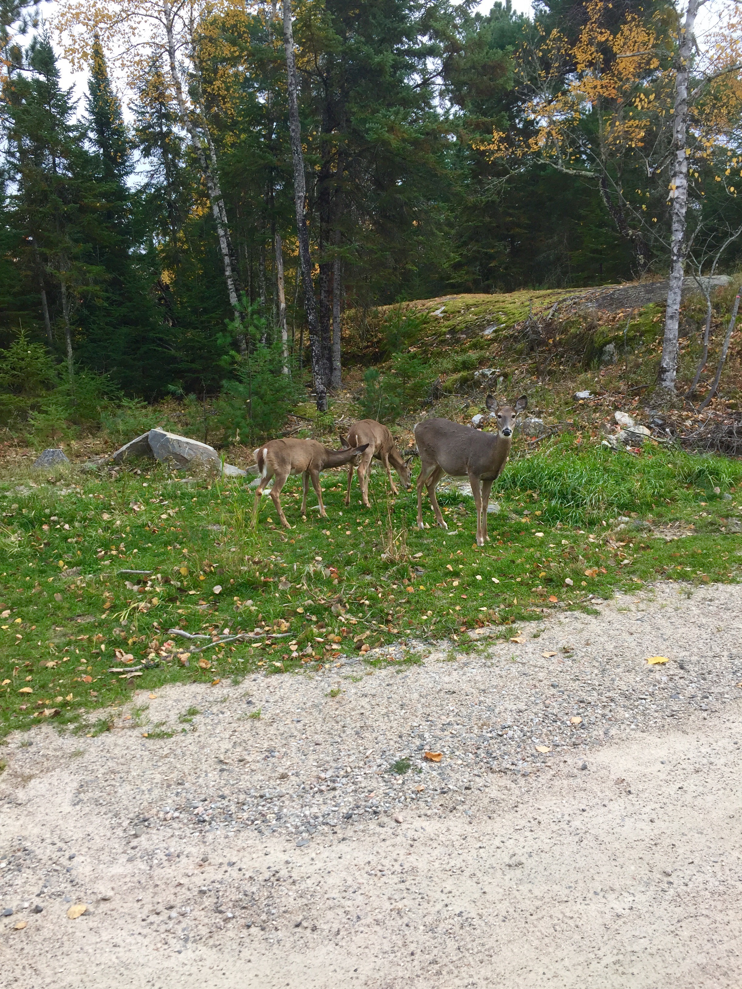
They are so not into me
As for the edge, it’s as though there isn’t one. For the bulk of the trip across the northern edge, the Rainy River marks the border. Everywhere there is room, homes dot the shore on the US side. Folks wake up and look out the kitchen window over coffee at Canada, not more than 100 yards away. They go get the paper and look out at America — and it goes on for a three day drive to the south at least. But there is not any sense of difference. The Canada ground looks the same, there is no particular sense of a border or control. If you wanted to go to Canada and you rowed your boat, you could be there in 5 or 10 minutes and I don’t think anyone would know the difference. I never saw a border control or customs official of any sort.
There is no wall, fence or even a sign about the border. I suspect this is a function of desire more than geography. There is no trade bridge or “International” bridge or anything. People in Canada are happy and busy, people in America are happy and busy. It’s not until International Falls, MN that you get any connection and it’s just sort of a left turn to Canada, over the bridge. I suspect during the dark ages of Prohibition there may have been some traffic across the Rainy, but all anyone there is doing now is catching Walleye.
Voyageurs National Park is a bit unique in that the entire park is basically on water. To really see the park, you need to get in a boat with some supplies and camp around the various islands. I didn’t have a boat, so I hiked around a bit and looked at the canoe paths and lakes from the shore. I’d like to go back with a boat. Voyageurs is named for the French Canadian traders who moved trade goods from Montreal to the the area and carried fur back. There’s would be a role that started wars (French and Indian) and stressed diplomats as the French, English and new Americans tried to sort out the border. Chiefly, they found a way from Montreal to the western edge of Rainy Lake, and managed the various competing Indians along the way. This route would ultimately become the US/Canadian border. They paddled big freighter type canoes, and played the middle politically. Practically the entire North Country of Minnnesota reveres them.
From Bemidji north, for the entire middle of the state there is basically nothing. So it’s no surprise that once you get up top, they sort of treat themselves as a separate thing. Everything is noted as “North Country” this or that. Insurance companies advertise insurance for “the North Country” as though it is a different thing. The people are uniformly nice. The cafes are full at all hours, first with farmers, then with locals for late coffee, then with lunch, then with retirees who take over the places to play cards. Every town has multiple bars and liquor stores, but the people drink strange things like sweet manhattans with olives. The other thing is that while it seems to be the middle of no where, there is almost constant civilization along the edge, though sparse. I didn’t find real wilderness until I went south from Voyageurs and found the Ely/Buyk Echo Trail across the Boundary Waters Canoe Area.
Superior National Forest
I had expected to be in the Superior National Forest (Boundary Waters) area tomorrow, but after getting to Voyageurs before lunch, I headed there today. Mercifully, the terrain changes a good deal as you move east — large granite formations appear and the forest goes from tiresome Aspen and Alder to larger conifer (though the Aspen remain). You also get more and more water — which helps create lovely vistas. Lakes and streams left from the glacial retreat hold beaver and waterfowl and give the ever present gray sky something to reflect, however dully, off. I loved Superior National Forest and would like to have stayed there. But today is opening day of something — juvenile deer season or moose season or something — and every two track I travelled ended with a couple of trucks. I’m happy about this. People getting out and around is a good thing. But when you are 20 miles from anything and you travel two miles down an unmarked road toward an un-named lake and find at the end a couple of trucks, and this happens over and over, you start to feel surrounded. So I kept pushing east, venturing off the dirt road on the two-tracks regularly, and ultimately, I ran out of forest and ended up in the community of Ely, MN. Which is lovely.
Bonus Superior National Forest
Tomorrow I will travel an hour and a half north to Grand Portage, then retrace my steps south along the shore of Lake Superior to Duluth or thereabouts. I can’t predict anything on this trip when it comes to where I will be when. I’m looking forward to the Great Gitchee Gumee and the change in scenery and, as always, I love being on the edge. I”m forever learning to be in the present and worry less about the what and where. The edge continues to make me better.
One of the hundreds of lakes in the Itasca watershed that contribute to the source of the Mississippi River
Having grown up in West Tennessee and crossed the Mississippi River at Memphis a million times going back and forth to my family’s home place, or the duck lease; and then having watched the musicals, read the novels and studied the history of the river, it was impossible for my mind to get around the burbling brook at my feet. But there it was, the Mississippi River, narrow enough to jump across, slipping over the bank of Lake Itasca and heading east and south to start catching water and dreams and dollars and lives. I started the morning in Red Wing and followed the river until it crossed under me around Hastings where it turned west after catching the water from the St. Croix. Now on the northern(eastern) bank of the river, I skirted north of the twin cities, caught up with it on the northwest side, and followed it straight up the middle of Minnesota past St. Cloud, Little Falls and Brainerd. At around Grand Rapids, the river starts jumping from lake to lake (one reason its source was so long a subject of debate) around and through the Chippewa National Forest before finally coming to the source at the northern end of Lake Itasca, south of Bemidji, MN.
The Mighty Mississippi as it tumbles out of Lake Itasca
Seeing the little brook at my feet brought home the point Paul Schneider makes in his excellent book “Old Man River”, the Mississippi is not one river, it is many rivers. There’s just enough water in the Lake Itasca watershed to get the Mississippi to Hastings where it gets its first real push from the St Croix. And from there it is off to the races — the Chippewa, the Des Moines, the Wisconsin, the Illinois, the Ohio, the Missouri, the Arkansas, the Red — I’m just cherry picking here, but you get the picture. Basically, the little brook called the Mississippi just happened to be the northernmost brook to slip into the ditch left when the ice sheet receded and the melting ice and lakes of the north blew down the depression between the Appalachians and the Rockies. I feel like it should be one of those “boost your confidence” tours to have people start at the little brook by Lake Itasca, then blindfold them and fly them to the tug docks at Memphis or New Orleans, turn them loose and say don’t let anyone tell you what you’re capable of — these are the same bodies of water.” Of course, it’s really just gravity and geology, but, hey, never let facts spoil a good sermon.
Choosing to follow the river to get to the spot I last left the edge was a good choice for me. It took longer, and was harder to plan for — I was wrong about most of the layover spots — but I saw genuinely new country (central Minnesota), and I fell under the spell of the river. It actually got physically harder to keep pushing upstream as the roads were less convenient and I had to go east to get west, or south to get north, because of all the lakes and bogs; but I will never forget kneeling by that little brook and thinking about that big river washing under the bridge at Memphis.
There are many lakes in the Itasca watershed that makes up the source of the Mississippi, and while the river actually flows from Itasca, the other lakes in the watershed are beautiful. This is Elk Lake, catching a particularly bright ray of sun
Oddly, once you get west of Itasca, the state is very different. While the trip up the middle was a glorious montage of rolling hills, rocks, bogs, birch forests and purple-blue lakes, the western state turns quickly to stony prairie with little to no interest at all. My guess is the ice sheet, and the way it receded has something to do with it. Itasca basically ended up on the northwest corner of the ditch. Once past it, you’re on the flat ground.
I made it to Grand Forks, ND, which is where I last left the edge. Tomorrow I will head north to the border where I will turn east along the top of Minnesota, through International Falls and out to Voyageurs National Park. What happens after that is unknown. The vast area of the Boundary Waters and Superior National Forest offer very little in the way of east-west routes unless you are in a boat you can portage on your shoulders. But I’ve found a couple of tracks that will allow me to stay pretty close to the edge as I work my way over to Ely and further east to Grand Portage. From there, it’s a matter of following the shores of the Great Lakes Superior, Huron and Erie. One thing I’ve learned venturing around the edge is that certainty is a rare commodity, so I only plan for tomorrow. And tomorrow, we get to the edge and follow it to Voyageurs.