An Edge for the Ages


I will blunder through this and generally make a hash of it, so let me start with a simple plea: if you can make, or ever have, the opportunity to travel from Northern Idaho through Glacier NP and across northern Montana, do it.  The entire route is shatteringly beautiful, diverse, and restores a sense of pride in a nation that can hold and protect lands and people such as these at the same time it argues on Wall Street and in Washington, DC.  The simple fact that we will fight and defend this land in equal measure with any other part of the country is a testament to our national fabric.  That we will also support an enlightened polity to protect some parts of it on behalf of all of us, redoubles that testament.

So first a bit about the northern edge.  We share this edge with Canada and it sprawls for around 4,000 miles, not including the shared border with Alaska.  First discussed in 1783 after the war for our independence, we agreed to a border that handled Nova Scotia down to New York (what is now Vermont) at the 45th parallel.  We further said in 1818, after another war in 1812, that a line would follow the 49th parallel as far as the headwaters of the Mississippi River. This was a bit of a problem since the headwaters of the Mississippi didn’t go that far north. Surveys ensued, we drug the Louisiana Purchase back out which gave us everything in the drainage of the Missouri River, argued some more and, in 1846 settled on the 49th parallel all the way to the Pacific.  These sorts of things can be a bit bothersome when you are arguing with your parents. I will eventually travel all of the shared border, but for now, I’m dealing with the part agreed to in 1846.

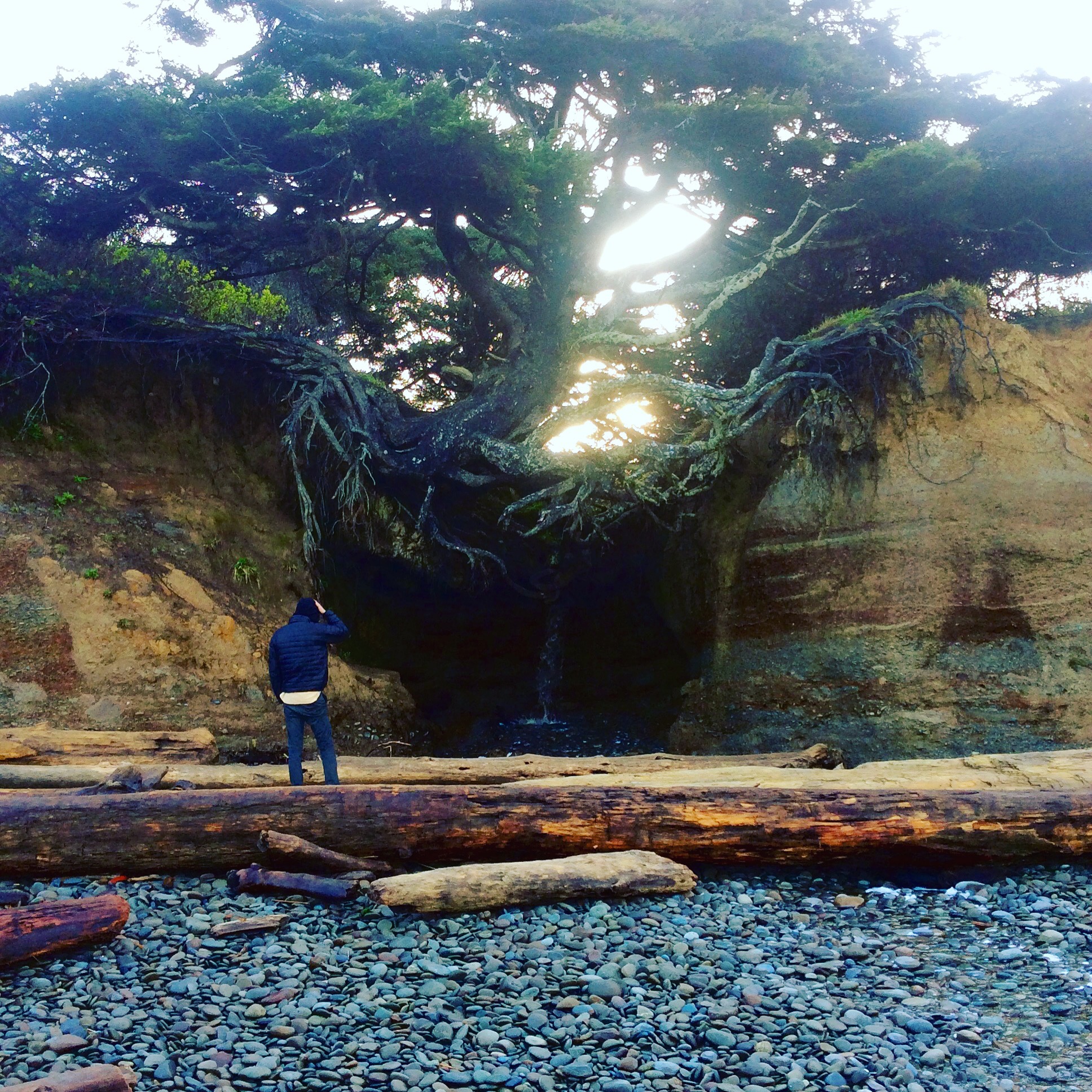
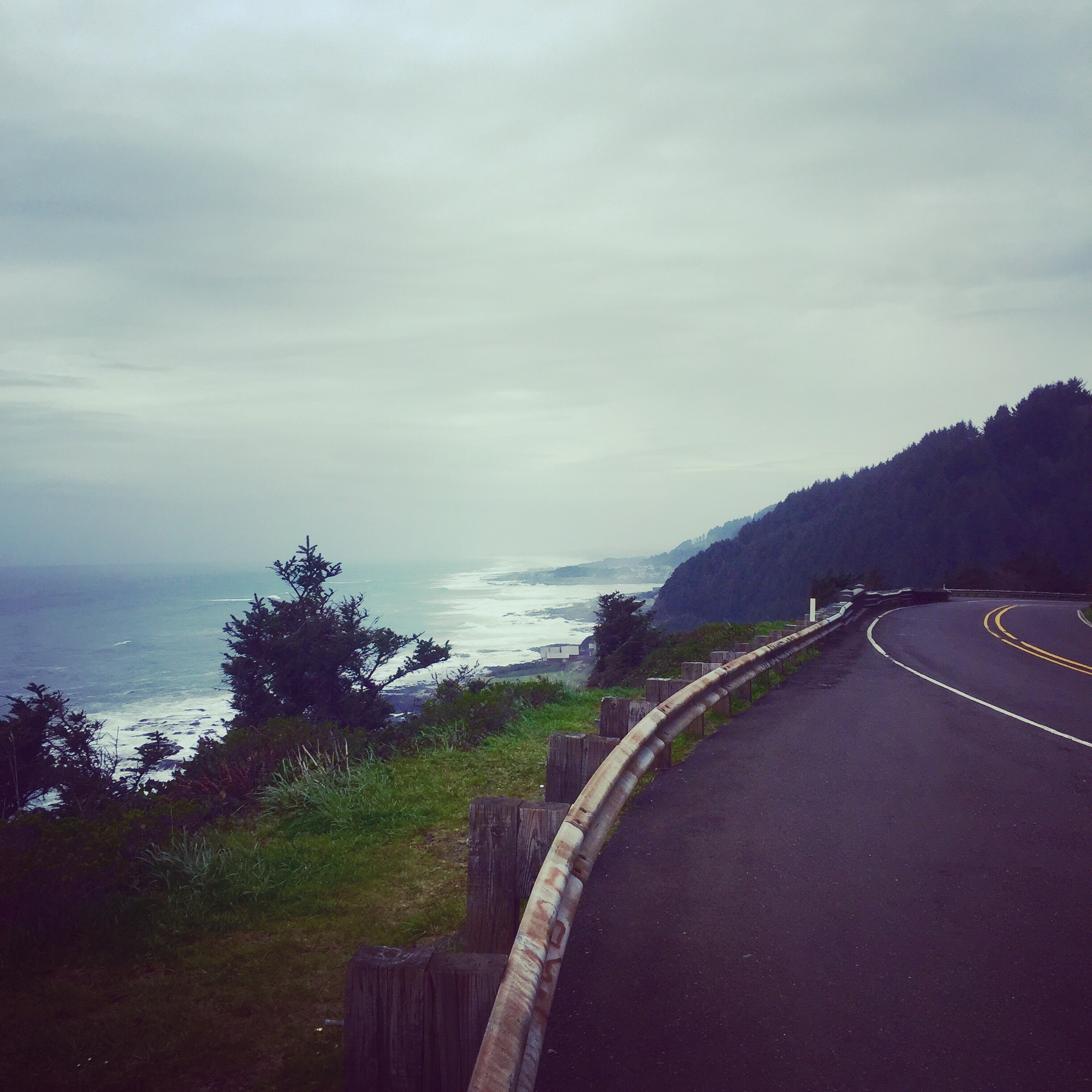
I left Sandpoint, Idaho this morning in a cold rain and climbed up the stovepipe to the Canadian border along US 2. I went on about it yesterday, but northern Idaho is great.  It is scenic and peaceful, it is lush and sparsely populated, and it is an odd little pokey thing sticking up between Montana and Washington.  I like all of that.  It also has a big section of the Kootenai River in it.  The Kootenai starts up in British Columbia, but eventually makes its way down and into the Columbia and from thence the Pacific Ocean in Oregon.  As a river it is a glorious beast of a thing.  It carries as much water as the mighty Columbia, but it does it at a much steeper grade and through much tighter spaces.  When a gold strike hit in British Columbia in the late 1800s, a guy named Edwin Bonner decided to mine the miners and he set up a ferry across the Kootenai that shortened the route to the gold for folks.  He did so well they named the town after him.  I crossed at Bonner’s Ferry, but there is a bridge there now.  Just upstream from the old ferry crossing are the West Falls of the Kootenai, and there you get a sense of the power of this river.  In addition to the 237 signs along the trail to the falls telling you how it will kill you, there is the thundering noise.  I expected, as I clambered down, some monstrous falls, when it is actually just a really tight spot and short drop.  (You can see a video of it on my Instagram @mlewis1965) But the entire river has to get through it because of the canyon walls. I got a real sense of how these rivers became barriers to migration west and why so many routes moved north or south to find ways across.  They are like the mountain passes of the Cascades and Sierras.

US 2 is turning out to be my favorite road so far on this journey around the edge.  It’s not directly on the border, but it is the closest east west road to it, and each little town has a sign on the north street where it crosses the highway that says “Canada.” The road is laid right on the ground and makes no attempt to hide the topography over which it runs.  There are no blasted cut-banks, or tunnels, or manufactured ways to avoid anything; it simply follows a route probably set out for a wagon trail at some point, and shows you the country.  For much of the way it is on, or about on, the route used by Lewis and Clark.

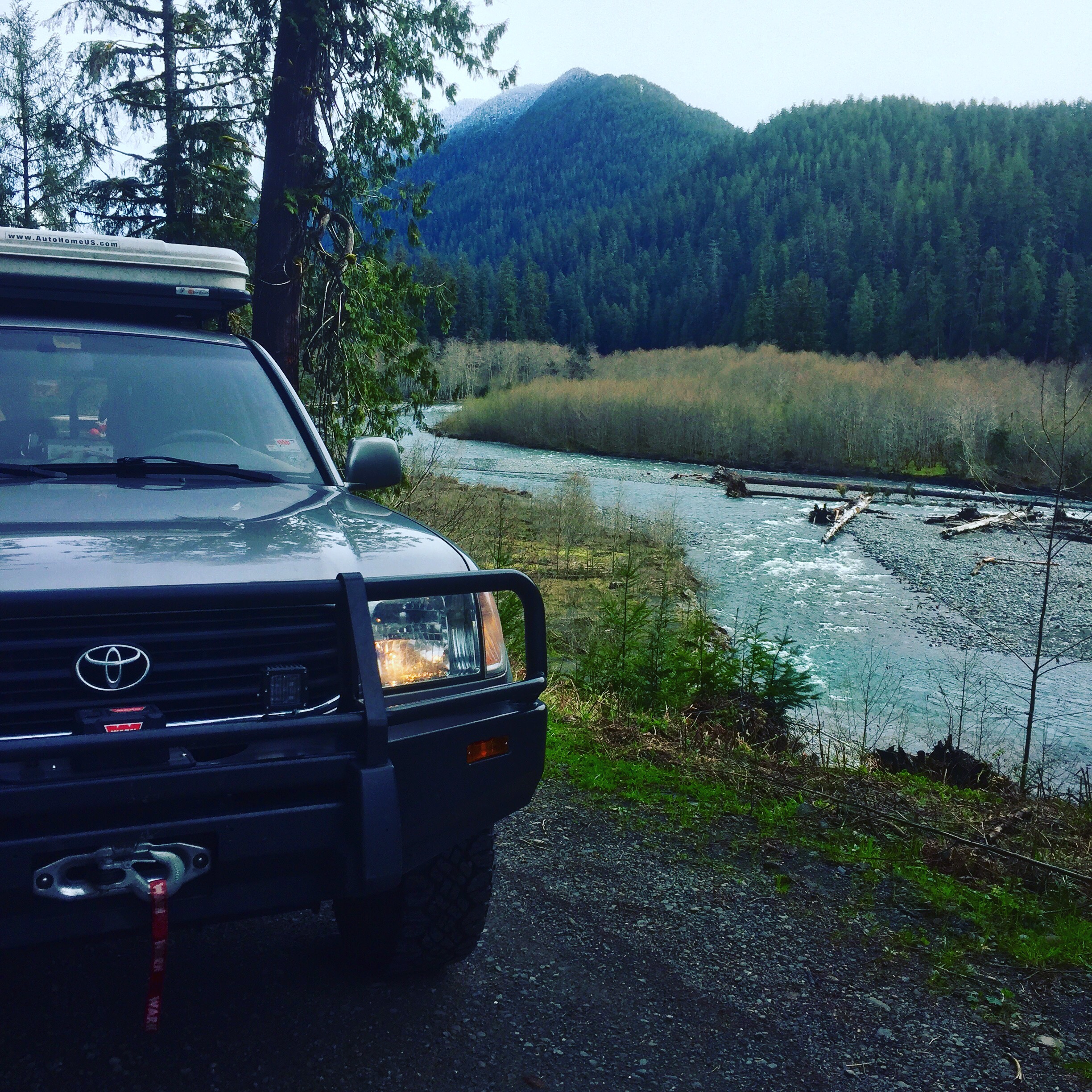
Riding US 2 out of northern Idaho and into Montana is a non-event.  You don’t so much cross into Montana as you simply find yourself in it.  There is no sign or great fanfare about the Big Sky state or anything.  The tarmac changes from black to brown and the speed limit changes from 60 to 70.  Not that you can safely do either for most of the time.  Likewise, the ecology remains essentially unchanged.  Deep valleys and sharp, dark canyon walls with pine forest wherever a root can grab ground is the order of the day.  It is spectacular and constant basically until you hit Kalispell, MT, fight a little traffic and come upon Glacier National Park.

Lake McDonald, Glacier NP
I keep t doing my Katherine Hepburn impression…”The Looooons, the loooons”

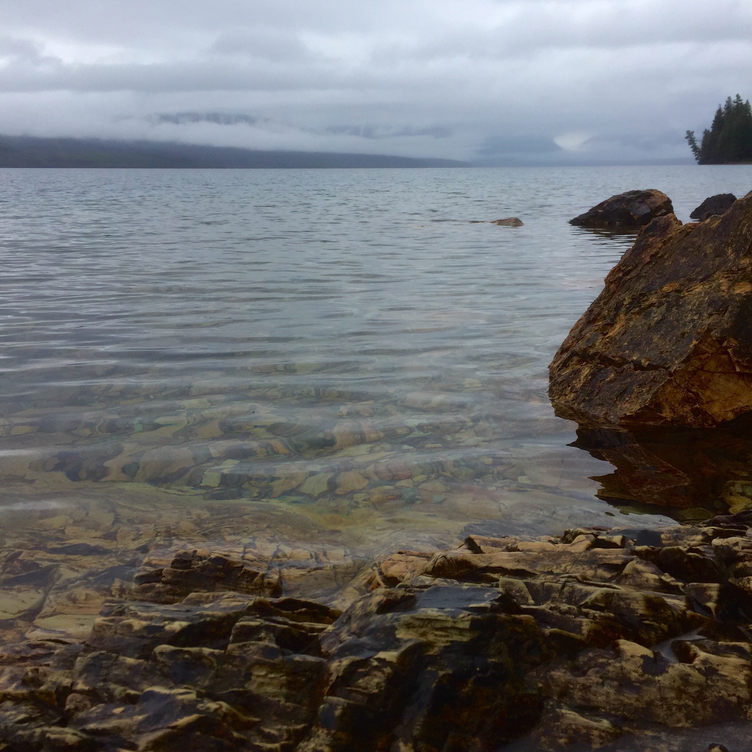
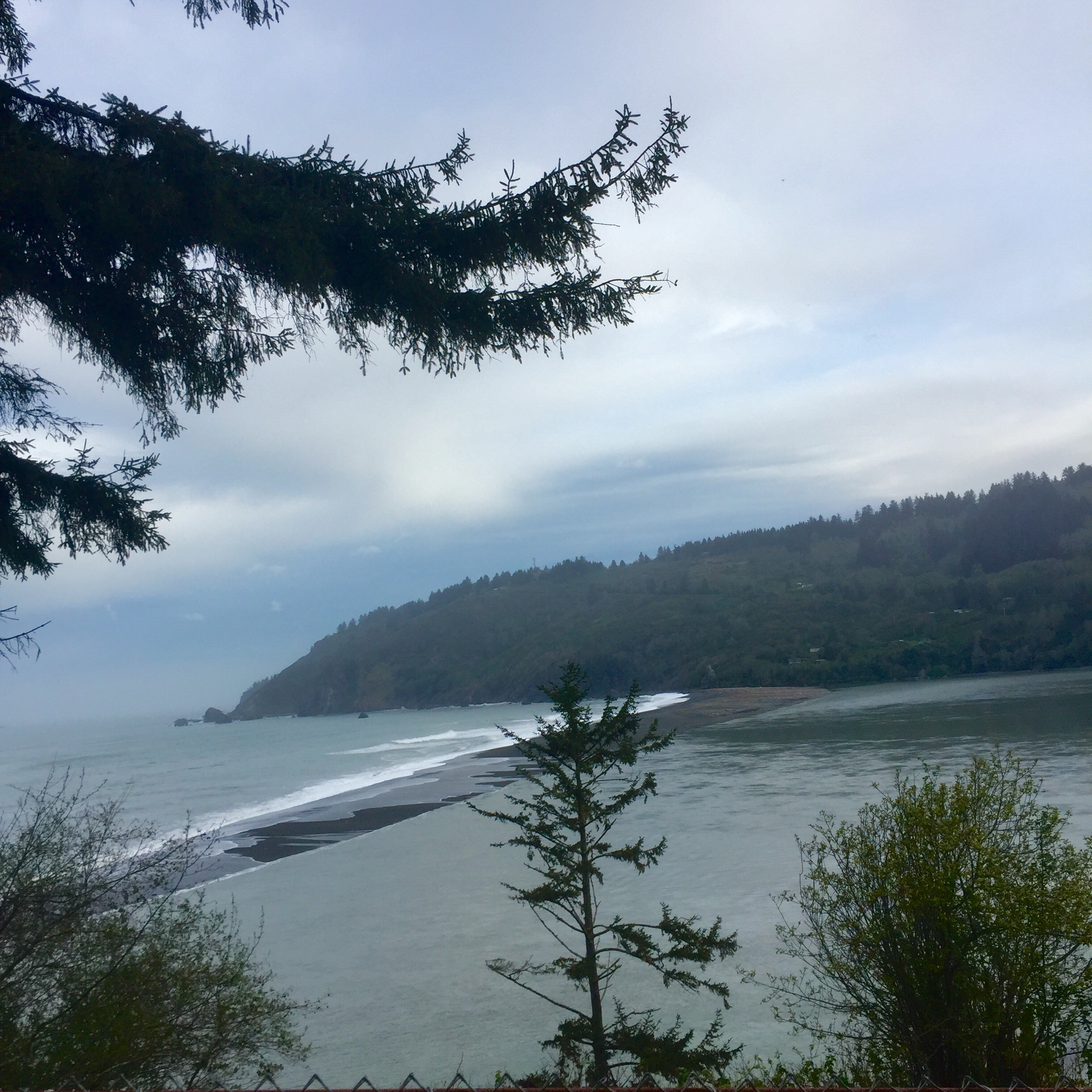
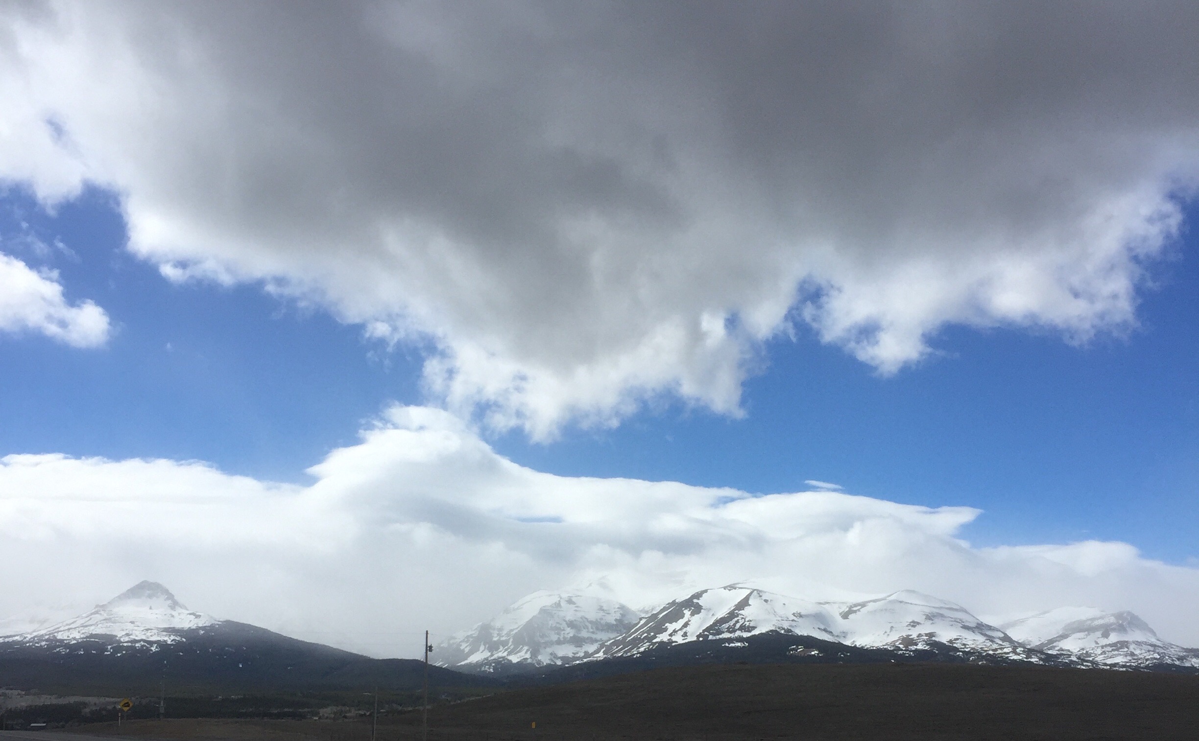
Glacier is over a million acres and today, most of it was closed. But from the first moment after entering the west gate, it was like a church. With even limited access I found the park to be unlike any other I have visited.  We share it with Canada as it crosses the 49th parallel and we have rules about that, but from any side and any angle, it simply stuns.  Glaciated peaks feed crashing streams that fill lakes so clear they look empty when you stare into them.  Deer walk along the roadside and eye you like you are a terrible bother, while loons and other waterfowl swim around the lakes looking at the water like I did, wondering what they are floating on.  I got to see all around McDonald Lake with all its great views, and take a couple of short hikes into the cedar and pine forests.  Locked gates kept me out of most of the park.  Without question, I will be back here in another season to spend a significant amount of time learning more.

Stopped and chatted with this crowd, but they were not interested

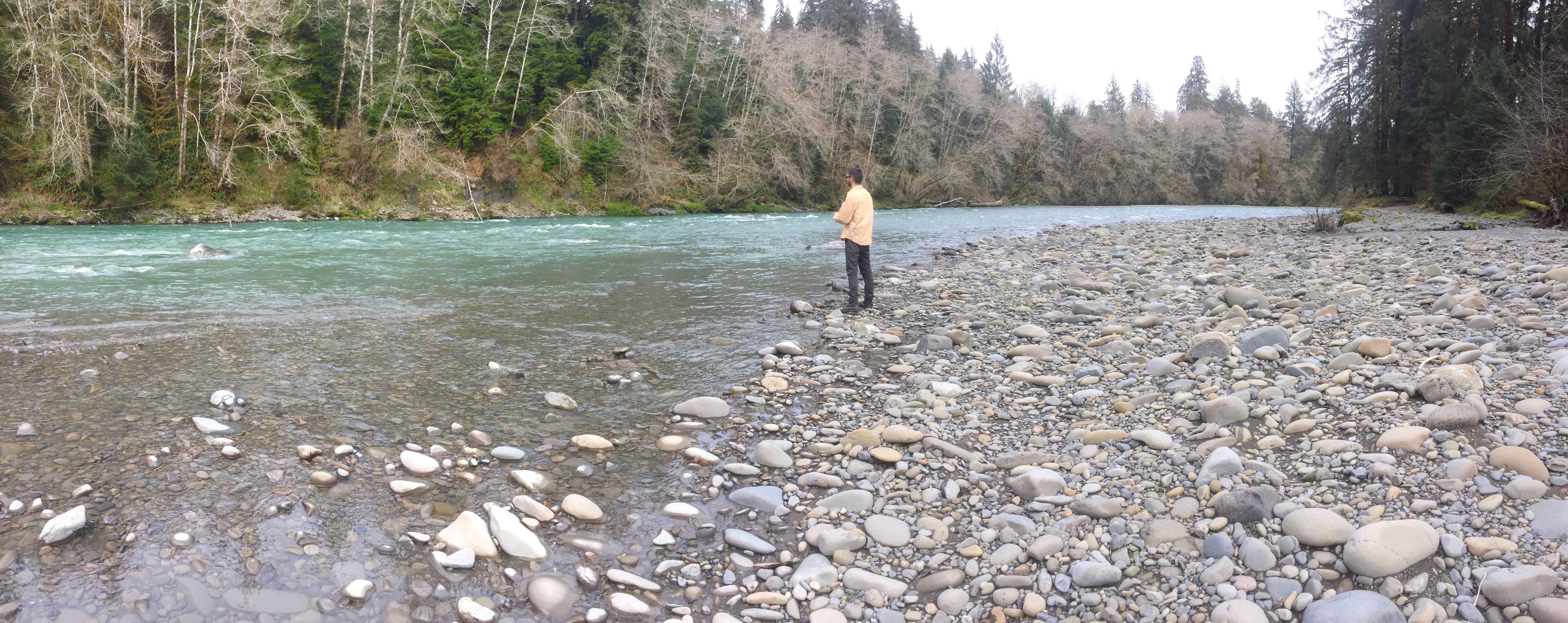
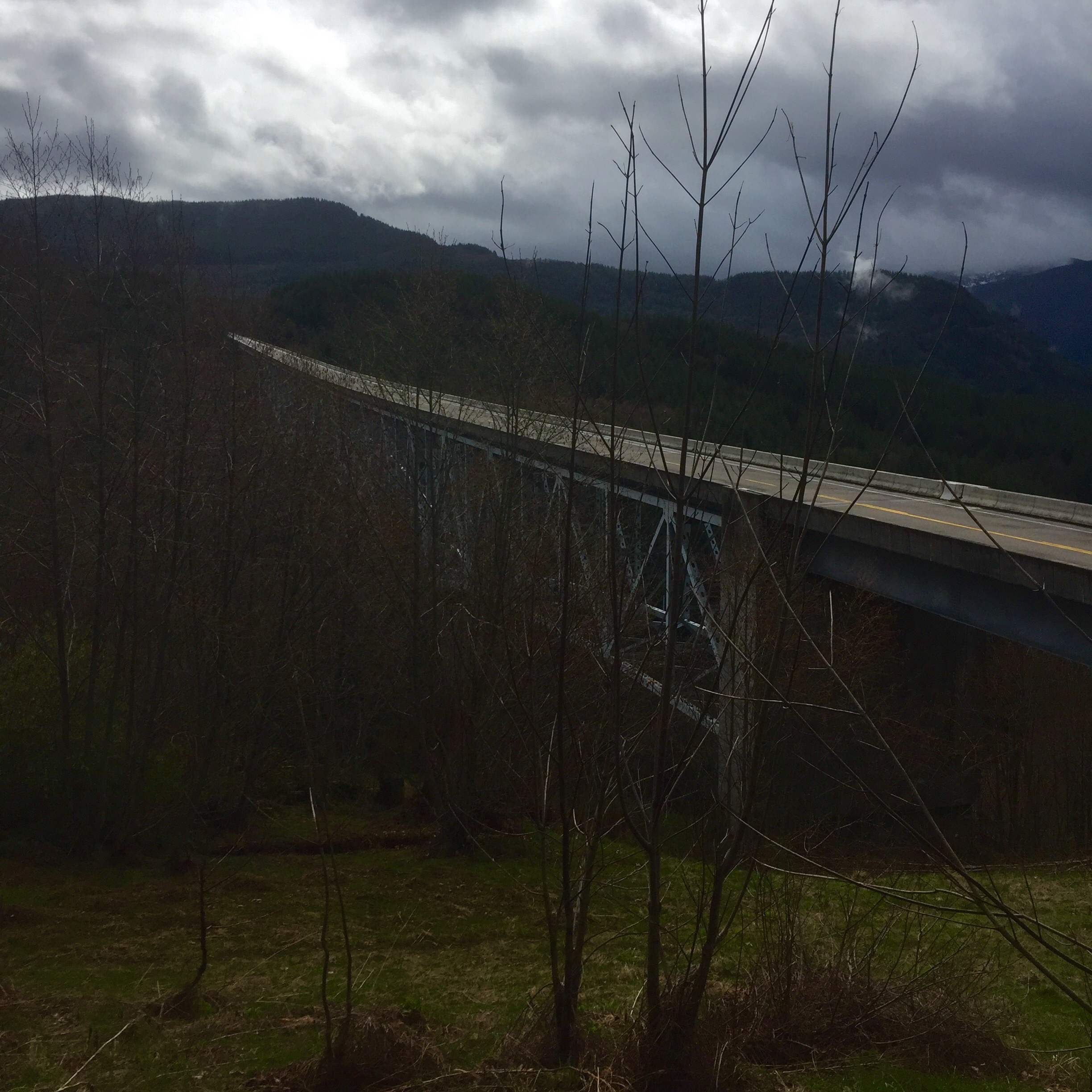
It’s really not fair to call my alternate route (instead of the road through the park, US 2 around its edges) a consolation prize.  The drive from West Glacier to East Glacier is practically worth an admission ticket.  You get constantly changing views of the mountains in the park, and you ride on the banks of first the Flathead River and then some river I don’t know the name of and countless other creeks for the entire route.  I don’t know how anyone who drives this road regularly ever gets anything done.  In addition to more deer, I saw a flock of turkeys, two fat coyotes and too many ducks to count. With all of that and the scenery, I felt lucky to keep the truck on the road.

The road turns south through Hungry Horse and into Essex before bending back east and heading down into Browning.  Just before you get to Browning you round a corner next to a nice little stream and bang. Big Sky unfolds corner to corner and top to bottom like a freshly laundered sheet. Gone are the jagged peaks and conifers and in their place, all at once, is sky and rolling grassland forever.  The wind comes screaming down out of the mountains and gives the old landcruiser a shove and we lope out into the vast open spaces of the Blackfeet.

The road here passes generally through the area named Camp Disappointment by Lewis and Clark on their return trip from the Pacific.   You can go to the actual camp when the four wheel drive road is open, which today it was not.  Looking back at the now sunlit snow caps of Glacier from here it is hard to see how disappointment enters into the equation, but Lewis and Clark were set on proving the Missouri drainage went past the 49th parallel all the way up to the 50th so they would have a case for us getting more land.  From their camp here, the scouts determined this was not so, hence the disappointment.

East Glacier looking from the area of Camp Disappoinment

From here on the topography is one for buffalo and Indian ponies.  The sky wraps around you and tucks itself in along the edges, and the ground rolls in subtle rises punctuated by loose folds around coulees and ponds. It’s just uneven enough that the light colors it in shadows and mottles the otherwise monochromatic grass and grain into something captivating.  And always there is the sky, which, as I cross Cut Bank Creek fills with clouds so that the fresh pastel sheet is replaced with fleece blanket.

I go way over my normal 8 hours on the wheel today, and I really don’t notice it all until I get to Hingham.  By then I’m over 9 hours in and its getting difficult to concentrate.  The toll of all the winding and gawking of the earlier part of the day is being paid.  I zoom by a pair of Pronghorn Antelope standing right on the shoulder of the road before I even realize it.  They are gorging on an early meal.  As the fleece blanket sky turns to a heavy gray wool I begin to think they know something. I finally call it a day at Havre, MT, spent but satiated.  I’ve made enough distance that it is possible tomorrow will be my last day on the edge for a while.  If I make Grand Forks, ND, that is where I turn south for Atlanta.  It will be an interesting effort tomorrow, with weather and the ghosts of the Yanktonais Sioux hanging about the entire way.  But it is the edge, and with each day on it, I learn and see more, and grow fonder and fonder of this incredible country we call home.

East

Sunset at Lake Pend Orielle Idaho. Thank God for Idaho.

I am headed east.  Not since starting this adventure along the edge at the mouth of the Mississippi River near Venice, LA, have I have traveled east on the edge.  Today, I dropped off the family at the Seattle airport, aimed north to find and the edge and then headed east. Although I am traveling against the tide of the historical settlement of this great land, I feel like I’m heading home.

This is not so easily done as said – this heading east.  One of the things that is leaving a real impression on me about traveling both to and along the edge of the country, is that out here away from the urban centers, you can’t just do what you want.  Nature and topography play a huge role what you are allowed to do.  You have to establish an objective and then figure out a way to accomplish it within the bounds of what is possible.  We would do well to understand this ethos as we seek to understand our fellow man, particularly those outside our immediate environs.  Life is different out here, and attitudes about life are correspondingly different as well.  As I try to find a pass through the Cascades that is open and that will get me to a reasonable route east, I live this out.  Almost 30 miles of State Route 20 through the pass at Ross Lake in North Cascades NP is closed for snow removal.  Until Memorial Day. I end up finding a way through further south on US 2 which, as it turns out, will be my road until the western edge of Minnesota.  It’s mildly frustrating because this means I will be some distance from the edge through eastern Washington, but such is life. I have GPS, a high-powered motor vehicle, climate control, access to food and water, etc.  Imagine the challenges of those who mapped these few passes through the Cascade Range.  From the Canadian border to the northern border of Oregon, there are like four passes east-west through the mountains.  All along this massive range of mountains, men trekked and plotted and found four ways to get through. To be honest, I don’t know how they found four.

It’s pretty amazing to go from the madness of an international airport to a snow capped pass through the mountains in a matter of an hour or so, but that’s what I did.  The trip through the Cascades was spectacular.  Every corner created an expectation of “getting through” only to render another climb, another twist, another car-roof-high bank of plowed snow on the shoulder.  Until, finally, the last corner comes. It feels like everything takes a deep breath all at once, and you stare, as you twist away downhill, at what seems like an endless horizon of space.  It really seems like you won’t see another mountain ever again. Most immediately, however, what you get is fertility.  For at the eastern base of the range, where the Columbia and Wenatchee Rivers come together, is a rich, broad valley of apples, vineyards and growth. In the eastern shadow of the mountains, protected from the worst weather, and fueled with the waters and nutrients of two great rivers, the orchards grow old and productive. Apple trees as thick as volkswagens are black-barked with age and yet still spread lacy branches wide and low for picking and, today at least, heavy with buds of new flowers.

I wish I could say this idyll lasted for a while, but it didn’t.  Just as soon as I had grown to appreciate the fertile valley, I was climbing, even cliff hanging, out of it along US 2 up onto what turns out to be the real response to the eastern shadow of the Cascade Range.  Absolutely nothing. In a weird twist of geography, invention, and weather patterns, I managed to find a stretch of eastern Washington that is nothing more than high, dry, scrub grass and grain fields for as far as you can see.  It is uninteresting, unattractive and really, really big.  Like the worst blind date you could imagine.  It’s in the rain shadow of the mountain range, and it’s denied natural water by the Grand Coulee dam to its north.  That dam, more on which in a second, does, however, irrigate up to a million acres of land SOUTH of this section of Washington. I’m driving right below the dam, but the irrigation is being used so far south of me I can’t even see green that direction.  In fact, I literally drive across the lower dam that creates the largest holding area of water south of the actual Grand Coulee dam when I go through Coulee City, and the place is dry as a chip.  I mean the reservoir is there and you can fish or whatever, but the surrounding landscape is practically lunar.

There is a deep and controversial history of the Grand Coulee Dam.  I’m not going to go into all of it, but the cliff notes is that businessmen and lawyers fought about whether a dam or a canal was the answer to providing water for irrigation and power downstate.  Then, with the dam-builders winning over the canal builders among the populace and politicians, there was an argument over low dam for power or high dam for power and irrigation. No where in all this was much discussion about the people, businesses, highways, cemeteries, etc. that were about to be underwater, low or high dam.  Anyway, the bureau of land reclamation moved forward with a low dam and when they brought out President Franklin Roosevelt to see the progress, he saw two things: 1) progress and 2) an good project for the WPA to help make some work for everyone in the depression.  So, like a good politician, he praised the work and promptly ordered a high dam.  In one of the more ironic twists of history, Woody Guthrie was paid to write a song about the effort, which he did, and in which he calls the Columbia River a “wild and wasted stream.”  The poet of the forgotten man forgot, momentarily, the fish and Native Americans and small business people who lost everything.  I’m not saying the dam was wrong, I’m just admiring the realities of capitalism when it comes to folk singers.  Finished in 1932 and improved in the late 70s, Grand Coulee generates more power than any hydroelectric facility in the US.  And it helps make this stretch of US 2 I travelled today as dry and boring as a math test.

In an absolute demonstration of a higher power, eastern Washington gives way to western Idaho.  Which is absolutely lovely.  The forests are back, the rivers are rushing and there is a snow capped peak in every vista.  Everything seems immediate, which makes sense given the narrow nature of this northern Idaho stovepipe. But mostly it is a relief from the vast bore of eastern Washington.  For me anyway.  I’m overnighting in Sandpoint, Idaho, and my spirits are high because not only am I back on the northern edge where I will be able to remain for a while, but I’m also headed into country I know is not boring.  Tomorrow I promise more photos as I traverse Glacier National Park and northern Montana, hopefully just past the middle of the state to somewhere around Havre.  After that, I will have the Missouri River at my southern side for a full day or so.  It all holds the promise of grand country and adventure.  I look forward to it.

Into the Rain Forest

The moon gives way to the sun and a new day on Kallaloch Beach

We awoke to a clear, cold morning with the Pacific finally earning its namesake washing rhythmically against the sand under a slightly blushing eastern sky, The tide was low, but coming in, and a mile or so walk down the beach was just what the doctor ordered for breakfast. Part of the way along we heard eagles, which we spotted overhead a hundred or so feet away on a lone Spruce bow. It was a pair, and securing what all women know of all males, regardless of species, the male eagle was pestering for a little sunrise action. He got it, literally while we watched, and we moved on down the beach somehow ashamed of our intrusion.

The coastal zone of Olympic is less dramatic, but somehow more isolated. It’s one thing to read about a 60 mile stretch of undeveloped coastline, it’s entirely another to be on one. We left it wetter, but more appreciative of the role the coastline plays in this park. It is a foil for the dense rain forests and high alpine zones it abuts. It is a character actor that makes the drama more complete. It is a good place to fall asleep and a good place to awaken to a new day.

Foster contemplates the straddling tree on or morning beach walk

We worked our way south and slightly east meaning to follow the Quinault River up to its juncture with Graves Creek, high in the rain forest. There we would fish and rest and see new territory. As it happens, the road was washed out above the last bridge of the Quinault and we we couldn’t get to Graves Creek. This sort of thing happens when you travel the back roads of the parks, they aren’t as maintained and they aren’t a priority. Certainly not in the off season as it is now. 

On the North shore of the Quinault in search of a road to Queets

 So we did what we do; we took the road that was open. Out of the park and into the National Forest, deeper north and east into the rain forest. Eventually, we were able to find a camp up the Queets River. We will sleep about 12 feet from the Queets River, in fact. It is a peaceful and nearly vacant camp, so we set up and head out to fish. An afternoon spent fly-fishing in a beautiful river is an afternoon well spent.

The Queets River

Dinner by the river, with a few bourbons, will give us a finale to this three act play of Olympic National Park. I have to say, it is the “Michael Jordan” of the parks. I’ve been to a lot of them, and it more than holds its own. Distinct regions, beautiful in their own right, collectively it can almost overwhelm. It’s best taken on the ground, in small frames, one region at a time. With a comfortable bourbon to ponder it.
Tomorrow, we head off the penninsula to clean the rig and pick up the family for a few days vacation on Vashon Island. But on the way, we will chat about our time together. And we will stop at Chelsea Farms for oysters. I could write a while to try and describe how nice times like this are. But I wouldn’t succeed.
I will be back here on Monday, plying the northern edge as I head east. See you then.

The Coastal Zone

It’s hard to leave a place like the forests of So-Duc, but we wean ourselves away with a morning trip up higher into the forest before we leave, and console ourselves with hopes of more great things to come.  It rained all night, maybe an inch or more, but it was a steady, sleep inducing rain; and we were warm and dry in the rooftop tent.  Both of us slept 10 hours,  I don’t remember ever sleeping 10 hours. This morning, we had coffee and breakfast, closed up shop and headed up the hill for another walk in this magical forest.


About a mile into the hike we found the falls we were looking for and spent a moment enjoying a brief period of sunshine that leaked between the dense vegetation. Then we said thanks, and headed back for the trip to the coastal zone of Olympic.

The rain, as it turns out, was just getting warmed up.  By the time we were turning around the northern edge of the park, it was pouring.  This would last unti dinner, only giving way long enough for a great sunset.  The plan had been a day on the beach exploring, walking down to several of the creeks that find the ocean here and maybe scaring up a salmon or two.  Instead, we sat together reading in the car, perched on a campsite right at the edge of the ocean.  Periodically we would get a break in the rain and stare at the gray sea. I grew enamored with a group of tiny sea ducks that fins something worth their time in the area of the water right where the waves break.  They land, dive for whatever it is, bob around ducking under the breakers, and dive again.  Like so many schoolchildren in the waves on Spring Break. I was watching them through the binoculars when right in the middle of the a mustachioed fellow popped up, rolled over and went to work on something on his stomach.  I’d seen a sea otter.  Say what you will about plans and weather, but an afternoon with your son reading good books and chatting by the sea, punctuated by seeing a sea otter in the wild is a good day indeed.


If the forecast is to be believed, the rain will cease tonight around 9 and the morning is supposed to be perfect.  Hopefully we will have some beach time before heading further down the coast and east into the rain forest.  At this point, I’m like those folks I mentioned earlier int he log — I’m going to be wet, so it doesn’t really matter.  Every aspect of this park is proving to be worth the discomfort.  I will go to shorelines again, and I will see more pretty beaches, but this is the longest stretch of undeveloped seacoast in the the lower 48 states.  And it is remarkable.  “Jordan” is still in the game and he’s putting up big numbers.

The Enchanted Forest


Most everyone has a vision of an enchanted forest.  I won’t tell you yours.  I will tell you about the Sol-Duc River and the accompanying old-growth fir forest of Olympic National Park.  Whatever your imagination is calling up about your enchanted forest now, double it.

We are sort of straddling the line between the eastern and western sides of the hat, if you recall yesterday’s post.  We aren’t yet fully in the temperate rain forest, but we are also not fully in the dry side the result is old growth forest hung deep with moss and lichen.  Quiet, but for the rushing sounds of the Sol-Duc river, and soft underfoot with the spring of decomposition.  It is a forest of every shade of green in the paint box.  Waxy, dark ferns, pale hair-like mosses, and everything in between.

We get a campsite and walk out into the forest.  Every step is a revelation in miniature.  Our pace is steps at a time because we keep stopping to study something else unseen. My son has the best analogy for this place: he calls it the coral reef of forests.  As I think about it, he’s right; these shapes and forms and details would be as at home underwater in vivid colors as they are here in their shades of green.  Their languid, variegated, featherish forms wave in the breeze as so many corals in the current.

It is cold up here still.  Snow remains in patches and the damp air cuts deeper in the 30s than one might expect.  But we are smitten with this place.  We will go higher still tomorrow for  another hike before descending to the coast.  Our first day and night are confirming the “Jordan” status of this park.  We will see if it can last the full game.

Olympic National Park

Note: I am going to post this in both “The Edge Trek” and in “National Parks,” but the posts for Sunday-Wednesday will all be “National Parks.”  I am technically off the edge, so to speak, right now to go deep into Olympic National Park with my son.  After Easter, I will return to the edge for a few more days and will be posting notes there accordingly.

Today was a day to straighten up the rig, re-supply a bit and generally get ready for a different sort of adventure for the next few days.  Part of the getting ready for me, involves doing a little learning about where I’m going to be and its history. I generally do this the same way anyone would; by consulting multiple sources, cross checking them against each other, reaching out to noted experts in the field for their unique perspective…Actually, I use Wiki for a quick overview, and then I dig into the bits I think are interesting directly by reading the cited articles and any subsequent threads to which they lead me.  For example, there is a study on old growth forests of the northwest cited in the Wiki write-up that was written by two US Foresters in 1993 and is 32 pages long.  I will read that tonight because I’m interested in it.  Anyway, today’s post will be a brief fact sheet on where I’ll be for the next few days.  The posts from the park will be more my typical type.

There have been humans on the Olympic Penninsula for over 12,000 years.  Until the 1500s, those humans were all likely predecessors to, or part of the indigenous Indian cultures we still find on the penninsula today.  The Hoh, Ozette, Makkah, Quinault, Quilente, Queets, Lower Elwha Klallam and the Jamestown S’Klallum tribes are the current representation of those cultures.  There are parts of the penninsula which belong to them, and which they control and own completely and which are neither National Park nor National Forest.

The official efforts at protecting the Olympic began in 1897 with good old Grover Cleveland (I don’t really know anything about Grover Cleavland, but it sounds like his name should always be preceded by “Good Old” for some reason).  He designated the bulk of the area as a Forest Reserve.  In 1909, Teddy Roosevelt named Mt. Olympus a National Monument in an effort to protect a unique strain of elk without having to discuss it with Congress.  The effort was successful and the “Roosevelt Elk” now roam all the way into Northern California.  There is a picture of some a few days back in the blog.  These elk don’t exist anywhere else and are bigger and genetically different from other elk in North America. Finally, Franklin Roosevelt got the deal completely done and created Olympic National Park as we know it in 1938.  In 1976, it would also gain the designation International Biosphere; in 1981, World Heritage Site, and 1988, Congress would designate it National Wilderness.  I feel like I’m going into the Michael Jordan of National Parks.

Alot of this fawning over the area and unique genetic material is because Olympic is almost cut-off from anywhere else.  In the natural world, this separation creates special opportunities for plants and animals.  Opportunities that can’t or don’t happen in areas where migration and cross-pollination are commonplace.  You can sort of think of Olympic as a steep, high pointed hat with a broad fishing bill on the western edge, hanging on a hat rack. The hook on the hat rack connects it to the rest of the state of Washington.  The high peak is the Alpine Zone, highlighted by Mt. Olympus at almost 8,000 feet and representing the highest concentration of glaciers of any non-volcanic peak in the lower 48.  It has one glacier over 3 miles long.  To the east of the peak, the side of the hat is dry, old growth forest ending at Puget Sound.  To the west of the peak, the side of the hat is temperate rain forest of conifer trees.  There is 100 inches of difference in rainfall between the two sides of the hat because of the rain shadow created by the Alpine Zone.  Finally, at the bottom of the western side of the hat, is a coastal area along the Pacific.  There are 62 miles of it and it includes the longest continuous sections of undeveloped coastline in the lower 48.

Over the next few days, we will visit and camp in three of the four regions — the old growth forest, the pacific coast and the temperate rain forest. Much like learning about the edge by being on the edge, there is nothing like taking a walk in the forest to see what you really think about it.  I don’t expect to have much if any cell coverage (thank God), but I will record it all in word and picture and look forward to posting exactly what I think about it all here.

The Corner

Pacific Beach looking north up the western edge

Another early start today, from Aberdeen — which calls itself “The Gateway to the Olympic Penninsula.” Rather than being Chamber of Commerce stuff, this is actually very true.  The body of water known as both North and South Bay combines with Puget Sound in the east, to make the Olympic Penninsula a penninsula. And Aberdeen sits right at the eastern head of the bay.  So, I opened the gate and headed out.

Rather than go on and on about the rain, I’ll just say; 1) the weather people are calling it a major storm, and 2) the local guy at the gas station shook his head at me and said “man, this is a nasty one.”  Of course the latter was standing in the 42 degree downpour with a steady 25 knot wind, wearing flip-flops and a t-shirt.  So, judgement is an issue in his case.  Regardless, it was a brutal weather day to head up the western edge basically into the teeth of the storm.

The ride goes from a steady dose of striking, fir-lined beaches, to the rain forests of the Olympic.  And finally, to Cape Flattery — as glorious a little piece of rock and forest as I will ever see.  I really like the beaches here more than any to date.  They have the right mix of action and calm, rock feature and sand, and, most of all, they have wonderful groves of fir right to the edge that make them feel like evergreen Tahiti.  In a freezer.  With rain.  They appear to be catching on a bit as well.  In between Copalis Beach and Pacific Beach, a planned community called Seabrooke has sprung up.  Georgeous, million+ homes with varied but familial designs, are neatly arranged in a couple of neighborhoods all clustered above beautiful beach with a mountain stream crashing through the rocks into the ocean.  I don’t  know what I could have expected less.

I run out of beach road at Moclips because of the Quinault indian Reservation.  I’m certain there a beach roads, or close to it, in the reservation, but I don’t have any maps, or any cell signal.  So I follow the Moclips road inland to the base of the mountains, hug that base north, and return to the beach on the other side of the reservation at the town of Queets.  Between Queets and Oil City, the National Park actually owns the beach and I will camp here with my son next Monday.  Today, I cruise the campground and make a few mental notes and save the details for my time with him.

The mountains reach the sea at Oil City and the road builders decided not to risk it.  There is no way to the northwest corner from here.  The only choice is to “cut off” the end of the Penninsula and come to the northwest corner from the east.  This requires some fumbling around with multiple roads all of which can go back to the place from which you came somehow, but I eventually wander into the right solution through the towns of Sappho and Clallum Bay.  From there it is a tight squeeze along the northern edge to Neah Bay, Classet, and finally, via the Makkah Indian Reservation, to the point called Cape Flattery.

Cape Flattery was “discovered” by Captain James Cook in 1778, who also named it.  It is the northwesternmost point of the lower 48 states.  To its west is the North Pacific, to its north is the Strait of Juan de Fuca (more on which in a minute). It is part of the Makkah Indian Reservation and for many years, long before we started worrying about edges, the Makkah were here; using the point as a look out, and hunting seals on the rock island just a few hundred yards off the point.  Today, the Tatoosh Island Lighthouse is on that rock island and the seals appear to be safe.   The 1,600 or so members of the Makkah Tribe that live in the US, all live here.  They earn a living from this small area by managing the forest lands.  To their immense credit (in my book) there is no casino — at least that I saw. You have to park and take a hike out to the point — a mile and half or so round trip downhill out and uphill back.  The hike is fantastic because the Makkah people don’t go out of their way to make it easy.  You clamber over roots in the deeply forested approach, and when trees fall, they are left for you to climb over.  Where possible, narrow boardwalks span low areas, or provide a semblance of stairs.  All of it is enwreathed in vegetation, moss, fog, and lichen covered branches from multiple species of trees.  If this isn’t on your bucket list, consider this: the only other people out there with me were two French folks.  And they were there.  Now, they could have been French-Canadians just there to figure out what happened in all the fur trade business that cost them this, but whatever.  They were great and I helped them get their picture together and we all just marveled at the place.

Along the Cape Flattery Trail
South side of Cape Flattery
North side of Cape Flattery
The “Hole in the Wall”

Near the end, you get views both to the south and the north where great cliffs fall away to the sea.  Cook said the presence of caves on one side looked like an opening that “flattered them with the hopes of finding a harbor” — hence the name.  Those same caves were the recent site (2 days ago) of tragedy when a second year student at Dartmouth ventured down to the “Hole in the Wall” to explore and was swept away by the sea.


From the overlook at the end of the Cape, you can look north across the Strait of Juan de Fuca to Vancouver Island. As the first section of my northern edge journey, the Strait of Juan de Fuca is of some interest. He was a Greek born in the 1500s who worked for the Spanish King as an explorer.  Apparently the Spanish couldn’t figure out his Greek name, so he took something close to it in Spanish.  He sailed all over the world, including China, and ended up getting his ship seized off the coast of Cabo and himself dumped ashore on the Baja.  Once he got himself together, he undertook two voyages for the Viceroy of Spain hoping to get rich from his discoveries — both of these were to the northwest in search of a “strait” that would shorten future routes.  Thing is, he never got paid, and there is no actual record of what he found.  Broke and irritated with the Spanish, he went back to Greece where he died.  He supposedly identified a Strait at 47 degrees latitude — the actual Strait is 48 degrees — but the only evidence of his discovery is writing from another explorer from England named Locke, who never really discovered anything.  Locke named the Strait for de Fuca.  Such are the vagaries of life on the edge.

I follow the so-called Strait of Juan de Fuca back along the northern edge to Port Aberdeen for the night.  Tomorrow I head close to Seattle to a real city — probably Olympia — to clean out the rig, re-supply, and get ready for my son.  Sunday morning, we go into the rain forests of Olympic National Park for a few days of camping before returning to Seattle to meet the rest of the family for a few days on Vashon Island, and Easter.  I will get back to the northern edge on the mainland after that for a couple of days, but today, I checked a big box.  I’ve now travelled the edge at the Gulf of Mexico, the entire shared southern edge, and the entire western edge.  I am making my way around.  Every mile from here on will feel like heading home — but it will also be against the tide of development that built the nation.  Today I marked a journey end that was essentially the only thing that stopped us — The Pacific Ocean. We have ventured further, successfully if painfully, but only when provoked and only in defense of the ground on which we stood.  This edge, this western edge, was the point from which we reached back inland, from which we recognized the power of a diverse and prolific landmass when knitted firmly together as a nation.  The leadership was from the east, but the glory was in the west, and in the getting there.  Today, I feel like I got there.

The edge of renewal


Before I get started tonight, I have to say RIP to Don Rickles. One time in my life I bought something from an info-mercial and it was the entire set of Dean Martin Roasts.  I gave them to my Dad because he used to let me stay up late on the bedroom floor watching them.  Red Buttons, Jonathan Winters and Don Rickles were the funniest thing I’d ever seen; or, frankly, have seen since.  I miss a time when we could just all laugh at ourselves and each other without getting all wound up about stuff.  The guy was all love and I will probably be up all night re-watching funny clips of him.

Today was my day to visit the volcano.  Thirty-seven years or so ago, Mt. St. Helen’s erupted surprisingly in the worst volcanic explosion in the history of the United States. Seismologists say the mountain went from dormant to active to explosive in a flash.  The lack of preparation/predictability meant lives lost and massive property damage. Occurring prior to the advent of countless experts on the television, the footage was just a simple narrative of what looked like Armageddon.  Visiting today, I was a bit awestruck; but not by devastation, by renewal.

The ride up from the coast was a slow climb along the southern shore of the Columbia river into the heart of timber.  Along the river, great processing plants for wood chips, paper and saw timber sprawled out with shipping docks on one side and rail lines on the other.  While severely industrial, unlike the refineries of say, Port Arthur — also on the edge — the product of these facilities is visible.  Neat stacks of freshly cut trees spread over acres awaiting the saw blade, great mounds of bark steaming the morning sun ready for shredding, and perfect squares of tightly wrapped 2×4’s headed for the Home Depot near you.  These are the factories of a renewable resource, obvious because they are surrounded by acre after acre after acre of more trees and clear cuts and fresh plantings.  I can’t argue for the practice of logging by clear cut, but I can rest easy knowing that there will always be trees.  These guys are making sure of that.

The view across Silver Lake to the cloud-wrapped Mt. St. Helens
At one point, before leaving the river to head east, there is a lowland area where the crop of choice is birch trees. I’ve never seen a birch tree farm before, but it is marvelous.  Straight and white and just beginning to shade green with new buds, the neat rows are mesmerizing and beautiful.  Even and precise they are like a tightly looped carpet over the ground that you can somehow see through.  I’m certain they too will be cleared one day, but I’m equally certain more will be planted.  I’m glad I caught these at the right time.

I leave the Columbia to head north to Castle Rock and then east on the Spirit Lake Highway to Mt. St. Helens.  It’s a 52 mile drive to the endpoint near the crater. Shortly after starting this last segment I swing into the Ranger Station to bone up on the details and there I learn that damn near the whole place is closed down.  The road to the observatory is closed about 4 miles from the top, the entire southern access is buried under a foot and half of snow, and every information center along any route is closed.  So, I go as far as I can.  Through Silver Lake and along the Toutle River up as far as just past South Coldwater. This means I enter the blast zone a little over halfway through the route.

Hoffstadt Creek Bridge

I enter the blast zone at the Hoffstadt Creek Bridge to the northwest of the crater.  This means I’m on the southwest edge of the zone because the blast was mostly to the north of the crater.  The total zone was roughly 150,000 acres of complete devatastation.  There was nothing left. For some perspective, the Hoffstadt Creek Bridge was gone and had to be rebuilt.  The bridge is over 2,300 feet long and 370 feet high. It was just one of 19 bridges, 16 miles of railroad, and 659 miles of road lost.

I never once today had any sense of any devastation at all.  Only the churning, chocolate milk Toutle River provides any indication of the massive amount of sediment/ash that once covered all of this. The Corps of Engineers had to build a special catch-basin to help contain the sediment.  Everything else, everything, looks fresh and new and beautiful. Certainly a great deal of credit goes to the timber industry.  Weyerhaeuser spent over $9 million in the early 80’s replanting damn near every tree.  Nature did the rest.  There are deer and elk, birds and fish, and everywhere trees.  There are open areas where you can see the stumps of trees blown down when a pyroclastic flow of rocks, super-heated steam and highly charged gas screamed down the mountainside.  But like the meadows of Yosemite, these open areas are vegetated with grasses and flowers and provide a nice foil to the deep green of the forests.

Castle Lake and Mt. St. Helens

I watched a documentary last night about all this and listened to scientists say that everything we thought about the natural recovery, all our understandings and long-held beliefs, and settled science, were wrong.  Within weeks of the eruption, they found gophers that had survived.  Next were Prairie Lupine, growing where they shouldn’t be. Soon came insects, salamanders and more.  The work of the timber industry meant forests were back sooner and, in short, we re-wrote our understanding of what nature can do.  So today, Mt. St. Helens feels fresh and renewed, and my long-distant memory shard of devastation is re-written as well.

On the way back to the coast where I left off, I stayed on the north side of the Columbia following the official Lewis and Clark Trail.  Somehow someone determined that while the terminus is on the south side of the river at Ft. Clatsop, the approach was on the north side.  It’s much nicer.  You can feel the great river spreading out and it breaks into braids of relaxation as it nears the coast.  I expect the explorers felt the ocean was around each bend.  The valley of Columbia and then the Grays River here on this side are stunning, with deep green pastures flush to the river edge full of grazing elk.

Out for an afternoon snack along the north shore of Grays River

Just east and north of Astoria, Oregon, I angle north to the edge of what is Willapa Bay.  Broad clam-rich tidal flats spread out in all directions dotted with locals up to their calves in the muck leaning on their rakes for a bucket of bi-valves.  Around Southbend at the head of the bay, I follow state road 105 back west to stay hard on the edge to Westport, and around South Bay to Aberdeen.  These protected bays mean the topography here in Washington is almost exclusively peaceful beach, complete with fishing villages and all manner of stout craft for making a life here on the edge.

The head of Willapa Bay looking west

Tomorrow I will complete the western edge and turn east at the Straits of Juan De Fuca.  I’m due to pick up my son in Seattle on Sunday for a sojourn deep into the Olympic National Park and by then, I will have completely circled it.  But until then, I have a few more days on the edge.  And, after today, I too am feeling renewed.

The edge of the storm

It seems a long time since the storms of Missouri at the outset of this journey, but I haven’t had any rain since then.  With countless wash-outs, mudslides, road closures and down trees, I’ve seen evidence of rain, but no actual rain.  That ended today and, by the looks of it, it’s going to be wet for a while.  

Morning in Lake County

I started out today in Lake County Oregon which is aptly named for a near constant chain of lakes just inland of the coast that turn the 101 into something of a penninsula for several miles.  To the west is the Pacific and a continuous row of towering dunes, the east, a broken range  of mountains fronted by a chain of flat, clear lakes.  Again, the forces that build, take away.  All the sand shuttled to the edge of the sea by the area rivers, you’ll recall, rises up on the North American Plate and forms the dunes; these, in turn, grow and seal off the rivers that gave them birth enough to create lakes on the inland side.  Like so many beaver dams biting the hand the feeds them. While it’s mildly reminiscent of the bayous and Gulf of Mexico arrangement I found on the edge in Louisiana, the steep mountains and fir forests make it somehow more European, if that makes sense.  As usual, we are the only thing that spoils (in my opinion) this tableau. The dunes are a commercial success for this area of Oregon because people like to recreate on them.  Specifically, people like to ride motorcycles and four-wheelers and dune buggies on them. I think Oregon does a good job managing this, and there is no evidence of destruction that I could see, however, the marketplace is a demanding thing and marketing is prolific for all manner of rental services and guided tours.  It all turns into a little too much of a roadside carnival in many places.  

Once across the Suislaw River, the 101 returns hard to the edge and to an ever grayer sea.  There is a storm at sea and it’s rolling inland.  My weather radio crackles on about a stalled cold front, and low pressure systems building along it, and swell heights and intervals, and small craft warnings, and all sorts of dire sounding things.  The throbbing ocean invites an unwilling shoreline to share its misery around every bend in a series of froth-framed views worthy of a J.M.W. Turner painting.  Combined with place names like “Devil’s Elbow,” “Seal Rock,” and “Cape Perpetua” the world takes on a more ancient feel.

Heceta Head Lighthouse

The storm begins to make landfall at Cape Perpetua in a foggy, sheeting rain that will stay with me for the remainder of the day (and from the looks of the forecast, forever).  It reduces visibility enough to render the views basically meaningless, and my attention is drawn to the more immediate.  This is not all bad.  For instance, I have the remarkable and nostalgic experience of a FULL SERVICE GAS STATION when I stop for fuel.  Seriously. Shuffling around in the seat to gather some trash before the exercise of manning the pump, I realize there is someone hovering by the window. When I open the door, he says “morning, what can I do for you?” Turns out Oregon is a full service gasoline state (at least this is what he tells me) and I spend a few happy moments chatting about the area and discussing national parks (he was intrigued by all my stickers) with him while he does the dirty work. I like full service gas stations.

Cape Perpetua and the road north

I also like how ubiquitous town pride seems to be.  The road here plies its way through small town after small town and every one is proud.  Of what represents a great variety, but each is very proud.  For instance, one is “world’s smallest harbor.” Another “world’s shortest river.” Not to be outdone, another is simply “world famous.” And each one sports a tiny, drive-through coffee shop of some local variety that has the absolute best coffee, according to them.  Amidst the heavy rain and fog and cold, I don’t see anyone in these towns who seems angry. Everywhere people are happily going about their daily routines, drinking coffee and showing off their “world’s whatever” gifts.  Without umbrellas.  In the lower 48 states, this area has the most rain of anywhere — over 100 inches a year.  As a business person, one would think this would be a hotbed for umbrella sales.  But no one carries them.  In six hours of driving through and around the area, I saw one, and it was being carried by a woman from California.  The locals seem to have decided they are very likely to be wet at any given point and hauling around extra gear that isn’t going to stop that from happening while simulaneuously poking all the other folks in the eye when they shuffle up for coffee just isn’t worth it. So they walk and stand around with their hoods up, chatting and shopping in the driving rain as if everything is normal. Which, for them, it is. 

The 101 generally cuts off the points and capes along the edge, but most of them are some sort of state park and generally have access roads.  Which I happily take.  On one such diversion out to Cape Lookout I find myself deep in a fir and birch forest, shrouded in fog and surrounded by man-sized ferns.  For three or four winding miles it feels like Jurassic Park.  It is oddly calming. Despite the fact that, once at Cape Lookout, there isn’t much looking out to do owing to the weather, I am glad I made the effort. The edge is the edge, 24/7 no matter the weather.

Cape Lookout

Tonight I am in Astoria. It, too, is a proud town, oddly choosing to highlight things like being the location for the movie “Goonies” ahead of things like, well, like being the first U.S. City on the west coast. Or being home to the terminus of Lewis and Clark’s famous transect.  It mentions those of course, but the t-shirts are focused elsewhere.  In 1811, John Jacob Astor’s Pacific Fur Company anchored up here at the mouth of the mighty Columbia River and claimed the place. Just two months later, the first man to come down the entire length of the Columbia, British explorer David Thompson, arrived from the other side to do the same, but alas, he was too late.  Astoria was American and would soon have the first post office west of the Rockies to prove it.  There was a good deal of fur business back and forth, and treatying associated with the war of 1812 that muddled up who actually owned what, but it was all settled by 1849 and the town grew into some prominence.  Once the fur business dwindled, the fishing and timber business took over and, until fairly recently, your Bumble Bee tuna was canned here.  The whole place is wet.  Originally built almost entirely on pilings sunk in the silt of the Columbia River, and almost entirely of wood, the whole town has burned to the ground twice. Construction materials have changed since then, but wet remains the prevailing nature of the place.

I’m headed inland tomorrow.  For some deep-seated, only explainable on a couch reason, I have three distinct memories of national tragedies (or what struck me at the time as national tragedies) growing up.  I remember Eisenhower’s funeral in 1969, which I watched sitting on the shag carpeted floor of 55 Woodhaven Drive on a grainy television screen; I remember Mt. St. Helens erupting in 1980; and I remember the Challenger explosion in 1986.  This is not to say I don’t remember any other national events, Reagan getting shot, Ford getting shot at, Vietnam footage from the trenches, etc. Just that these three events stand out as national tragedies in my memory for some reason.  I don’t know why and God knows I don’t have the stomach to figure it out, but I do have the ability to confront one of them.  I’m doing that tomorrow by driving up to Mt. St. Helens.  Site of the most destructive and deadly volcanic explosion in US history. And an odd memory fragment of mine. The volcano has been quiet since 2008 and I’m counting on it taking a day off tomorrow as well. So I will climb to about 8,000 feet, see the elephant, so to speak, and no doubt learn a great deal more about all the plates and shifting and grinding of the land we call home.  Then I will return to the edge to ride out the gathering storm.

The edge of correction

Seems like only yesterday i was wondering if the edge would hold.  Of course, that’s because I actually typed those exact words yesterday.  Then, at about 10 minutes to eight, the actual spot in the picture of the Gold Bluffs that I published yesterday, broke off.  Off.  BOOM, like a mortar landed, and then the whole middle section tumbled down the bluff with a hiss.  Nobody got hurt, and we wouldn’t know until this morning if it blocked our road out (it didn’t, not entirely), but boy howdy does it get your attention.  Awarding a victory to the edge, it seems, may have been a bit premature.

I was up and out early this morning, anxious to check the road and, frankly, anxious to get out of California.  I love California, I just feel like over the past two trips I’ve been in it for a long time.  I was ready to see Oregon, and learn new things.

An early departure from the beach to see if the road held

It didn’t take long.  Since about Eureka, CA, yesterday, I’ve been noting a difference in the edge.  Giving credit to the redwoods for holding the banks, I attributed the difference to them. What’s really happening is very different, and may move things a tick more in the direction of the Pacific. It’s at about Eureka that the Cascadia Subduction Zone and the North American Plate meet. This, in fact, rather than the sea and the edge, is where the battle is raging.  The North American Plate – that’s us – is moving southwest, and the Cascadia Zone (which is three plates and runs all the way to Vancouver) is moving east.  The Cascadia plates are not as heavy as the North American Plate and so they are sliding under it.  This pushes the North American Plate up, but it also scrapes off the top of the Cascadia Plates and leaves the resulting sand and rock piled up on the edge. Sometimes the resulting pile is populated by trees, sometimes it is a tumble of rocks, sometimes it is piles of sand. And it is all happening well below us as the country continues to grow and change.  As the evidence at Gold Bluffs last night suggests, the edge is always changing.

At the mouth of the second largest river in California, the Klamath, I see the shifting sands of the edge face to face.  There is a sandbar here where the river meets the sea and it moves contnuously, at some times nearly separating the river from its intended target altogether.  Further north, deeper into the Cascadia Subduction Zone, I see a softer edge.  To be sure there are still rocky promontories, but things are rounder.  There is more earth involved.  The valleys are broader and the hills are less violent.  Dense groves of fir replace the redwoods and stand, waiting for the axe, as far as the eye can see.  This is timber country.  Hillsides are dotted with clear cuts, soaking in the sun that will nurture the next generation of timber framing. While unsightly, it only takes seeing a couple that are 10 or 15 years old and full of beautiful young fir to give one a sense of renewal.

The shifting sandbar at the Klamath River

I miss the western most part of the Oregon edge at Point Blanco due to a closed road, and have to settle for the second westernmost further north at Cape Arago.  Between them, I get up close and personal with the effects of the Cascadia Subduction Zone around Bandon.  The famous golf course notwithstanding, the bulk of this area along the edge is massive, Sahara-like sand dunes.  Shining tan dunes contrast with the gray sands of the beaches and demonstrate a different a source material.  100,000 years ago is when it started.  Sands from the surrounding rivers, chiefly the Umpqua trundled downstream only to be met with a rising coastal plain where the North American Plate slid over the Cascadia Plates.  There they piled up, shaped by the winds, and there they remain.  The youngest of them began forming 7,000 years ago. Dotted with tree islands of dark green Spruce and Fir, they are oddly beautiful.

Just north of the dunes, I find Cape Arago.  Bang out into the ocean north of the shipping village of Coos Bay, it is marked by the Cape Arago Lighthouse steering boats clear of the rocky Wilsons Reef.  Sir Francis Drake supposedly anchored up here in the shelter of the point in the early 1500’s and the cape is named for his French surveyor. I chat with an old dude sitting in the wind with his binoculars who comes here regularly to look for whales.  He doesn’t photograph them, he just looks at them.  Said he’s been doing it for years.  He seems supremely happy.

Cape Arago and the reef

I’m anchoring up tonight in Reedsport, OR. There isn’t much here, but I did find a decent hotel. After a week and half mostly sleeping outside, I could use a little re-boot.  Tomorrow I will keep pushing north to the Washington border at Astoria and, perhaps, make a side trip inland to see Mt. St. Helens.  I expect to have many more of my pre-conceptions and ill-drawn conclusions shattered along the way.